In geology, the places known as hotspots or hot spots are volcanic regions thought to be fed by underlying mantle that is anomalously hot compared with the surrounding mantle. They may be on, near to, or far from tectonic plate boundaries. Currently, there are two hypotheses that attempt to explain their origins. One suggests that hotspots are due to mantle plumes that rise as thermal diapirs from the core–mantle boundary. The other hypothesis is that lithospheric extension permits the passive rising of melt from shallow depths. This hypothesis considers the term "hotspot" to be a misnomer, asserting that the mantle source beneath them is, in fact, not anomalously hot at all. Well known examples include Hawaii, Iceland and Yellowstone.
The origins of the concept of hotspots lie in the work of J. Tuzo Wilson, who postulated in 1963 that the Hawaiian Islands result from the slow movement of a tectonic plate across a hot region beneath the surface. It was later postulated that hotspots are fed by narrow streams of hot mantle rising from the Earth's core–mantle boundary in a structure called a mantle plume. Whether or not such mantle plumes exist is currently the subject of a major controversy in Earth science. Estimates for the number of hotspots postulated to be fed by mantle plumes has ranged from about 20 to several thousands, over the years, with most geologists considering a few tens to exist. Hawaii, Réunion, Yellowstone, Galápagos, and Iceland are some of the currently most active volcanic regions to which the hypothesis is applied.
Most hotspot volcanoes are basaltic (e.g., Hawaii, Tahiti). As a result, they are less explosive than subduction zone volcanoes, in which water is trapped under the overriding plate. Where hotspots occur in continental regions, basaltic magma rises through the continental crust, which melts to form rhyolites. These rhyolites can form violent eruptions. For example, the Yellowstone Caldera was formed by some of the most powerful volcanic explosions in geologic history. However, when the rhyolite is completely erupted, it may be followed by eruptions of basaltic magma rising through the same lithospheric fissures (cracks in the lithosphere). An example of this activity is the Ilgachuz Range in British Columbia, which was created by an early complex series of trachyte and rhyolite eruptions, and late extrusion of a sequence of basaltic lava flows.
The hotspot hypothesis is now closely linked to the mantle plume hypothesis.
Comparison with island arc volcanoes
Hotspot volcanoes are considered to have a fundamentally different origin from island arc volcanoes. The latter form over subduction zones, at converging plate boundaries. When one oceanic plate meets another, the denser plate is forced downward into a deep ocean trench. This plate, as it is subducted, releases water into the base of the over-riding plate, and this water mixes with the rock, thus changing its composition causing some rock to melt and rise. It is this that fuels a chain of volcanoes, such as the Aleutian Islands, near Alaska.
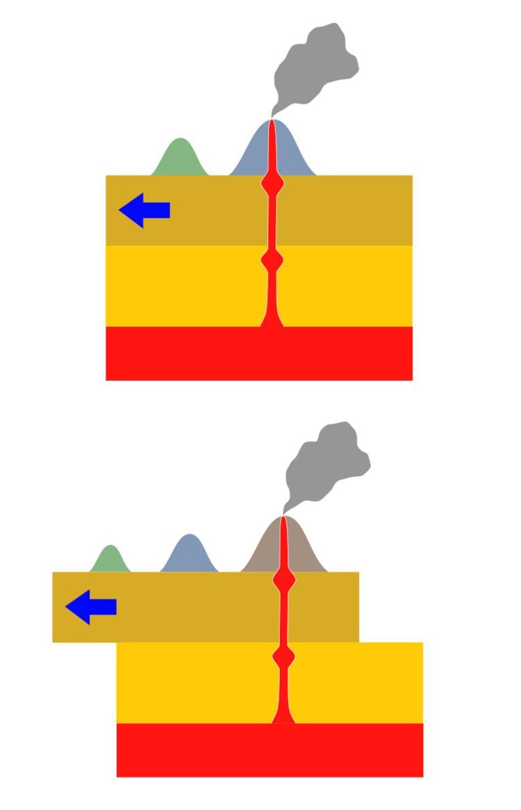
The joint mantle plume/hotspot hypothesis envisages the feeder structures to be fixed relative to one another, with the continents and seafloor drifting overhead. The hypothesis thus predicts that time-progressive chains of volcanoes are developed on the surface. Examples are Yellowstone, which lies at the end of a chain of extinct calderas, which become progressively older to the west. Another example is the Hawaiian archipelago, where islands become progressively older and more deeply eroded to the northwest.
Geologists have tried to use hotspot volcanic chains to track the movement of the Earth's tectonic plates. This effort has been vexed by the lack of very long chains, by the fact that many are not time-progressive (e.g. the Galápagos) and by the fact that hotspots do not appear to be fixed relative to one another (e.g. Hawaii and Iceland.)
Hawaiian–Emperor seamount chain (Hawaii hotspot)Louisville Ridge (Louisville hotspot)Walvis Ridge (Gough and Tristan hotspot)Kodiak–Bowie Seamount chain (Bowie hotspot)Cobb–Eickelberg Seamount chain (Cobb hotspot)New England Seamounts (New England hotspot)Anahim Volcanic Belt (Anahim hotspot)Mackenzie dike swarm (Mackenzie hotspot)Great Meteor hotspot track (New England hotspot)St. Helena Seamount Chain – Cameroon Volcanic Line (Saint Helena hotspot)Southern Mascarene Plateau–Chagos-Maldives-Laccadive Ridge (Réunion hotspot)Ninety East Ridge (Kerguelen hotspot)Tuamotu–Line Island chain (Easter hotspot)Austral–Gilbert–Marshall chain (Macdonald hotspot)Juan Fernández Ridge (Juan Fernández hotspot)Tasmantid Seamount Chain (Tasmantid hotspot)Eifel hotspot (8)50°12′N 6°42′E, w= 1 az= 082° ±8° rate= 12 ±2 mm/yr Iceland hotspot (14)64°24′N 17°18′W Eurasian Plate, w= .8 az= 075° ±10° rate= 5 ±3 mm/yrNorth American Plate, w= .8 az= 287° ±10° rate= 15 ±5 mm/yrPossibly related to the North Atlantic continental rifting (62 Ma), Greenland.Azores hotspot (1)37°54′N 26°00′W Eurasian Plate, w= .5 az= 110° ±12°North American Plate, w= .3 az= 280° ±15°Jan Mayen hotspot (15)71°N 9°W Hainan hotspot (46)20°N 110°E, az= 000° ±15° Mount Etna (47)37°45.304′N 14°59.715′E Hoggar hotspot (13)23°18′N 5°36′E, w= .3 az= 046° ±12° Tibesti hotspot (40)20°48′N 17°30′E, w= .2 az= 030° ±15° Jebel Marra/Darfur hotspot (6)13°00′N 24°12′E, w= .5 az= 045° ±8° Afar hotspot (29, misplaced in map)7°00′N 39°30′E, w= .2 az= 030° ±15° rate= 16 ±8 mm/yr Possibly related to the Afar Triple Junction, 30 Ma.Cameroon hotspot (17)2°00′N 5°06′E, w= .3 az= 032° ±3° rate= 15 ±5 mm/yr Madeira hotspot (48)32°36′N 17°18′W, w= .3 az= 055° ±15° rate= 8 ±3 mm/yr Canary hotspot (18)28°12′N 18°00′W, w= 1 az= 094° ±8° rate= 20 ±4 mm/yr New England/Great Meteor hotspot (28)29°24′N 29°12′W, w= .8 az= 040° ±10° Cape Verde hotspot (19)16°00′N 24°00′W, w= .2 az= 060° ±30° St. Helena hotspot (34)16°30′S 9°30′W, w= 1 az= 078° ±5° rate= 20 ±3 mm/yr Gough hotspot (49), at 40°19' S 9°56' W.40°18′S 10°00′E, w= .8 az= 079° ±5° rate= 18 ±3 mm/yr Tristan hotspot (42), at 37°07′ S 12°17′ W.37°12′S 12°18′W Vema hotspot (Vema Seamount, 43), at 31°38' S 8°20' E.32°06′S 6°18′W Related maybe to the Paraná and Etendeka traps (c. 132 Ma) through the Walvis Ridge.Discovery hotspot (50) (Discovery Seamounts)43°00′S 2°42′W, w= 1 az= 068° ±3° Bouvet hotspot (51)54°24′S 3°24′E Shona/Meteor hotspot (27)51°24′S 1°00′W, w= .3 az= 074° ±6° Réunion hotspot (33)21°12′S 55°42′E, w= .8 az= 047° ±10° rate= 40 ±10 mm/yr Possibly related to the Deccan Traps (main events: 68.5–66 Ma)Comoros hotspot (21)11°30′S 43°18′E, w= .5 az=118 ±10° rate=35 ±10 mm/yr Marion hotspot (25)46°54′S 37°36′E, w= .5 az= 080° ±12° Crozet hotspot (52)46°06′S 50°12′E, w= .8 az= 109° ±10° rate= 25 ±13 mm/yr Possibly related to the Karoo-Ferrar geologic province (183 Ma)Kerguelen hotspot (20)49°36′S 69°00′E, w= .2 az= 050° ±30° rate= 3 ±1 mm/yr Île Saint-Paul and Île Amsterdam could be part of the Kerguelen hotspot trail (St. Paul is probably not another hotspot)Related maybe to the Kerguelen Plateau (130 Ma)Heard hotspot (53)53°06′S 73°30′E, w= .2 az= 030° ±20° Balleny hotspot (2)67°36′S 164°48′E, w= .2 az= 325° ±7° Erebus hotspot (54)77°30′S 167°12′E Trindade/Martin Vaz hotspot (41)20°30′S 28°48′W, w= 1 az= 264° ±5° Fernando hotspot (9)3°48′S 32°24′W, w= 1 az= 266° ±7° Possibly related to the Central Atlantic Magmatic Province (c. 200 Ma)Ascension hotspot (55)7°54′S 14°18′W Bermuda hotspot (56)32°36′N 64°18′W, w= .3 az= 260° ±15° Yellowstone hotspot (44)44°30′N 110°24′W, w= .8 az= 235° ±5° rate= 26 ±5 mm/yr Possibly related to the Columbia River Basalt Group (17–14 Ma).Raton hotspot (32)36°48′N 104°06′W, w= 1 az= 240°±4° rate= 30 ±20 mm/yr Anahim hotspot (45)52°54′0″N 123°44′0″W (Nazko Cone)Lord Howe hotspot (22)34°42′S 159°48′E, w= .8 az= 351° ±10° Tasmantid hotspot (39)40°24′S 155°30′E, w= .8 az= 007° ±5° rate= 63 ±5 mm/yr East Australia hotspot (30)40°48′S 146°00′E, w= .3 az= 000° ±15° rate= 65 ±3 mm/yr Juan Fernández hotspot (16)33°54′S 81°48′W, w= 1 az= 084° ±3° rate= 80 ±20 mm/yr San Felix hotspot (36)26°24′S 80°06′W, w= .3 az= 083° ±8° Easter hotspot (7)26°24′S 106°30′W, w= 1 az= 087° ±3° rate= 95 ±5 mm/yr Galápagos hotspot (10)0°24′S 91°36′W Nazca Plate, w= 1 az= 096° ±5° rate= 55 ±8 mm/yrCocos Plate, w= .5 az= 045° ±6°Possibly related to the Caribbean large igneous province (main events: 95–88 Ma).Louisville hotspot (23)53°36′S 140°36′W, w= 1 az= 316° ±5° rate= 67 ±5 mm/yr Possibly related to the Ontong Java Plateau (125–120 Ma).Foundation hotspot (57)37°42′S 111°06′W, w= 1 az= 292° ±3° rate= 80 ±6 mm/yr Macdonald hotspot (24)29°00′S 140°18′W, w= 1 az= 289° ±6° rate= 105 ±10 mm/yr North Austral/President Thiers (President Thiers Bank, 58)25°36′S 143°18′W, w= (1.0) azim= 293° ± 3° rate= 75 ±15 mm/yr Arago hotspot (Arago Seamount, 59)23°24′S 150°42′W, w= 1 azim= 296° ±4° rate= 120 ±20 mm/yr Maria/Southern Cook hotspot (Îles Maria, 60)20°12′S 153°48′W, w= 0.8 az= 300° ±4° Samoa hotspot (35)14°30′S 168°12′W, w= .8 az= 285°±5° rate= 95 ±20 mm/yr Crough hotspot (Crough Seamount, 61)26°54′S 114°36′W, w= .8 az= 284° ± 2° Pitcairn hotspot (31)25°24′S 129°18′W, w= 1 az= 293° ±3° rate= 90 ±15 mm/yr Society/Tahiti hotspot (38)18°12′S 148°24′W, w= .8 az= 295°±5° rate= 109 ±10 mm/yr Marquesas hotspot (26)10°30′S 139°00′W, w= .5 az= 319° ±8° rate= 93 ±7 mm/yr Caroline hotspot (4)4°48′N 164°24′E, w= 1 az= 289° ±4° rate= 135 ±20 mm/yr Hawaii hotspot (12)19°00′N 155°12′W, w= 1 az= 304° ±3° rate= 92 ±3 mm/yr Possibly related to the Siberian Traps (251–250 Ma).Socorro/Revillagigedos hotspot (37)19°00′N 111°00′W Guadalupe hotspot (11)27°42′N 114°30′W, w= .8 az= 292° ±5° rate= 80 ±10 mm/yr Cobb hotspot (5)46°00′N 130°06′W, w= 1 az= 321° ±5° rate= 43 ±3 mm/yr Bowie/Pratt-Welker hotspot (3)53°00′N 134°48′W, w=.8 az= 306° ±4° rate= 40 ±20 mm/yr Euterpe/Musicians hotspot (Musicians Seamounts) Mackenzie hotspotMatachewan hotspot