
Highest point Mount Augusta Population 15 (2008) | Highest elevation 4,257 ft (1,297.5 m) State Baja California Area 244 km² | |
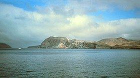 | ||
Great white shark cage diving guadalupe island baja california mexico
Guadalupe Island or Isla Guadalupe is a volcanic island located 241 kilometres (150 mi) off the west coast of Mexico's Baja California Peninsula and some 400 kilometres (250 mi) southwest of the city of Ensenada in the state of Baja California, in the Pacific Ocean. The two other Mexican island groups in the Pacific Ocean that are not on the continental shelf are Revillagigedo Islands and Rocas Alijos.
Contents
- Great white shark cage diving guadalupe island baja california mexico
- Map of Guadalupe Island Baja California Mexico
- Great white sharks of guadalupe island mexico
- Administration and population
- Geography
- Climate
- Geology
- Ecology
- Habitat types
- Endemism
- Extinctions
- References
Map of Guadalupe Island, Baja California, Mexico
Great white sharks of guadalupe island mexico
Administration and population
The 2010 census recorded a population of 213 people on the island. Guadalupe is part of Ensenada delegación, one of the 24 delegaciones or subdivisions of Ensenada Municipality of the Mexican state of Baja California. Ensenada delegación and Chapultepec delegación together form the city of Ensenada, the municipal seat of the namesake municipality. The postal code of Guadalupe Island is 22997.
Campo Oeste ("West Camp", also called Campo Tepeyac, with 15 buildings) is a small community of abalone and lobster fishermen, located on the western coast, specifically on the north side of West Anchorage, a bay that provides protection from the strong winds and swells that whip the islands during winter. Generators provide electricity, and a military vessel brings 30,000 liters of fresh water. The number of fishermen varies annually depending on the fishing season. Ten months of the year the 30 families of the fishing cooperative "Abuloneros and Langosteros of Guadalupe Island" are present.
Additional temporary fishing camps are Campo Norte ("North Camp", four buildings), Campo Lima (Campo Corrals) (one building) and Arroyitos (four buildings).
An abandoned fishing community, Campo Este ("East Camp"), is located near a cove on the eastern shore.
At the southern tip, on Melpómene Cove, there is a weather station staffed by a detachment from the Mexican Ministry of the Navy. The site is called Campamento Sur ("South Encampment").
Campo Bosque was established as a temporary camp in 1999 in the cypress forest in the north. The camp houses members of the Cooperative Farming Society "Francisco Javier Maytorena, S.C. of R.L." and removes goats from the island and sells them in the State of Sonora, with permission of Secretariat of the Environment and Natural Resources (SEMARNAT) and the support of the Secretariat of the Navy.
Campo Pista is located at the small airport, near the center of the island (29°01′24.04″N 118°16′21.75″W, elevation:592 m, direction:05/23).[1] Airport Isla Guadalupe (ICAO Code MMGD) has a 1,200-metre-long (3,900 ft) runway. At the end of the runway near threshold 5 is the wreckage of a Lockheed Model 18 Lodestar, which overshot the runway during landing. A former North American B-25J-30/32 Mitchell, BMM-3501 (c/n 44-86712), bomber wrecked on the opposite end of the runway, after suffering serious damage in trying to take-off overloaded (29°01′36.10″N 118°16′2.98″W). This B-25 wreckage was removed from the island in late 2005 or early 2006.
Geography
Guadalupe has a rugged landscape. It consists of two ancient overlapping shield volcanoes, of which the northern and higher volcano is the younger. The island measures 35 kilometres (22 mi) north-south and up to 9.5 kilometres (5.9 mi) east-west, with a total area of 243.988 km2 (94.204 sq mi). It features a chain of high volcanic mountain ridges which rises to a height of 1,298 metres (4,259 ft) at its northern end (Mount Augusta). Its smaller counterpart on the southern end is the 975 metres (3,199 ft) El Picacho. The southern part of the island is barren, but there are fertile valleys and trees in the northern part. The coast generally consists of rocky bluffs with detached rocks fronting some of them. Two high and prominent islets are within three kilometres (1.9 mi) of the southwestern end of the island, separated from one another by a gap called Tuna Alley:
Elsewhere, the other islets are very small and close to the shore, all less than one kilometre (0.62 mi) away:
Climate
The island has two major climate zones: a very arid, semi-hot climate between 0 and 800 metres (0 and 2,625 feet) elevation, with mean annual temperature between 18 and 22 °C (64 and 72 °F) and a very arid, temperate climate above 800 metres (2,600 ft) elevation with temperatures over 22 °C (72 °F) in the hottest month of the year.
Most precipitation occurs over the winter months with strong influence of northwestern winds and cyclones.
Rainfall averages 133 millimetres (5.2 in) near sea level at the south end but appears to be much more at the high north end. An estimate for the rainfall in the northern highlands is possible by way of taking Pinus radiata as an indicator, which is native to that area of the island. Other places where Pinus radiata is native, it grows best with about 750 millimetres (30 in) of rainfall but under some conditions can survive with as little as half that much. The effective moisture, of course, is much greater because of fog drip.
Geology
Guadalupe Island is composed of oceanic shield volcanoes which formed on a now extinct mid-oceanic ridge. The volcanic rocks of the island consist of olivine basalt and trachyte.
Ecology
Guadalupe Island was a major destination for Russian and American fur hunters seeking the Guadalupe fur seal (Arctocephalus townsendi) in the 18th and 19th centuries, until they were nearly extinct by 1844. Captain Auguste Duhaut-Cilly reported in 1827 that a Sandwich Islands (Hawaiian Islands) brig "had spent several months there and collected three thousand sealskins". The northern elephant seal (Mirounga angustirostris) was also ruthlessly hunted for the oil in its blubber. They were thought to be extinct in 1884 until a remnant population of eight individuals was discovered on Guadalupe Island in 1892 by a Smithsonian expedition, who promptly killed seven of them for their collections. The elephant seals managed to survive, and were finally protected by the Mexican government in 1922. All surviving northern elephant seals share the same male ancestor.
Guadalupe shares the California chaparral and woodlands ecoregion with the Channel Islands of California in the United States, but the island was at one time practically denuded of all plants higher than a few centimeters by up to 100,000 feral goats.
Originally brought there in the 19th century by European whalers and sealers for provisions when stopping over, the population eventually eliminated most vegetation; the number of goats declined to a few thousand. The main impact of the goat population was before this collapse, about the turn of the 19th/20th century. Naturalist A.W. Anthony wrote in 1901:
"It is directly due to the despised Billy-goat that many interesting species of plants formerly abundant are now extinct, and also that one or more of the birds peculiar to the island has disappeared, and others are following rapidly."
After the crash, the goat population once again grew, this time more slowly, until it had reached the new, lower carrying capacity at maybe 10,000–20,000 in modern times. The island had been a nature conservancy area since August 16, 1928, making it one of the oldest reserves in Mexico. Eradication of the goats was long envisioned, but logistical difficulties such as island size and lack of suitable spots for landing and encamping hunters and material prevented this. As of June 2005, after many years of false starts, the Mexican government has almost completed a round-up and evacuation of the remaining goat population and Guadalupe has been designated a biosphere reserve.
French sea captain Auguste Duhaut-Cilly remarked on the tall trees on the north of Guadalupe Island as he sailed past on January 2, 1827. Of the large tree species on Guadalupe Island (Guadalupe palm, Guadalupe cypress, island oak, and Guadalupe pine), there were only old individuals left; California juniper had entirely disappeared. As the goats ate any seedlings that managed to germinate, no regeneration of trees was possible. Water, formerly plentiful as the common fogs condensed in the forests of the northern end of the island, today only occurs in a few scattered pools and springs. Because the springs were a critical emergency water supply for the human inhabitants, protective measures including goat fences were installed beginning in 2000, allowing new seedlings of many species to survive for the first time in 150 years. Seacology, a non-profit environmental group located in Berkeley, CA, provided funding to the Island Conservation & Ecology Group for the construction of ten fenced exclosures to keep goats out of the most sensitive areas of Guadalupe Island.
In November 1850, U.S. Army Lt. George H. Derby passed the island on his expedition in the U.S. Transport Invincible. He described it thus: "This island is about 15 miles length and 5 in width. It is rocky + mountainous but capped with vegetation and is reputed to be thickly inhabited by wild goats of unusual size. Water is found upon the eastern shore and the Island is frequently visited by small vessels engaged in the capture of the sea elephant numbers of which animals are found upon its coast."
Many island or marine species that reside on or near Guadalupe also frequent the Channel Islands, and vice versa. In stark contrast to the rampant extinction of terrestrial life that happened at the same time, Guadalupe was the last refuge for the northern elephant seal (Mirounga angustirostris) and the Guadalupe fur seal (Arctocephalus townsendi) in the 1890s. The island has been a pinniped sanctuary since 1975.
Guadalupe is considered one of the best spots in the world for sightings of the great white shark, possibly because of its large population of pinnipeds.
Habitat types
Before the removal of goats, surveys found eight major land habitats on Guadalupe:
- Flora of the coastal lowlands and rocky cliffs: mainly up to 200 m above mean sea level (ASL), but higher on the steep cliffs. Largely unresearched due to difficult access, the cliffs might even harbor remnant specimens of the presumably extinct plants.
- Succulent perennial herbs: 200–400 m ASL, chiefly on the southern end and on the offshore islets, and in less steep areas towards sea level. Here, the highest number of endemic plants exist. Baeriopsis guadalupensis, Cistanthe guadalupensis, Dudleya guadalupensis, Hemizonia greeneana ssp. greeneana, H. palmeri, Perityle incana and Stephanomeria guadalupensis are dominant endemics, and giant coreopsis (Coreopsis gigantea), a non-endemic native species, is also abundant.
- Arid maritime shrubland: 400–600 m ASL. Mainly in the southern portion around El Picacho. Native species occurring here include Ambrosia camphorata, Atriplex barclayana, Cylindropuntia prolifera and California boxthorn (Lycium californicum); none of these is endemic.
- Herbland dominated by introduced plants: 600–800 m ASL, mainly on the central plateau. This habitat is almost entirely a consequence of overgrazing; hardly anything of the original ecosystem remains. Dominant introduced plants are Avena barbata, Bromus berteroanus, great brome (B. diandrus), soft brome (B. hordeaceus sspp. hordaceus and mollis), red brome (B. madritensis ssp. rubens), tocalote (Centaurea melitensis), nettle-leaved goosefoot (Chenopodium murale), Filago californica, wall barley (Hordeum murinum sspp. glaucum and leporinum), crystalline iceplant (Mesembryanthemum crystallinum), M. nodiflorum, Polypogon monspeliensis and Sisymbrium orientale. The non-endemic natives dwarf coastweed (Amblyopappus pusillus), island false bindweed (Calystegia macrostegia ssp. macrostegia), Cryptantha maritima var. maritima, Filago arizonica, Gilia nevinii, California goldfields (Lasthenia californica), Pectocarya palmeri and Perityle emoryi as well as the endemics Cryptantha foliosa and Sphaeralcea palmeri can be found here also; some are still numerous. This probably was a mesic shrub/herbland before the goats destroyed the upland forest, upsetting the water supply. Native plants still found on Guadalupe, like Crossosoma californicum, laurel sumac (Malosma laurina) and the endemic Camissonia guadalupensis ssp. guadalupensis, presumably thrived here in former times, as would have such taxa as the native hoary-leaved ceanothus (Ceanothus crassifolius), wedge-leaved ceanothus (C. cuneatus) – and possibly also felt-leaved ceanothus (C. arboreus), which was found in 2001–2003 surveys –, Cammisonia robusta, red-flowering currant (Ribes sanguineum) and the endemic Hesperalea palmeri, which have now disappeared from the island.
- Guadalupe palm groves: 400–900 m ASL on the northwest side of the island. There are hundreds of palm trees remaining, mainly in a single patch of this habitat. At least one other major palm forest, at the W coast, existed; it was still present in 1906 at "Steamer Point". As reproduction is presumably still ongoing, the species will likely recover in due time.
- Guadalupe cypress forest: 800–1000 m ASL. Presently some 4000 of old trees, essentially limited to the central northern part. Other cypress forests, such as a major stand NE of the present patch which was still extant in 1906, have been destroyed by the goats early in the 20th century. There is still reproduction, but the water table appears to have declined to below the level required by the cypresses, and mortality of the old trees is high and can be expected to continue even after removal of the goats.
- Guadalupe palm – island oak – Guadalupe pine woodland: 900–1000 m ASL. This habitat has all but disappeared during the 20th century, due to the decline in numbers of the oaks and pines.
- Guadalupe pine cloud forest with some island oak: restricted to above 1000 m ASL on the N-NE point of the island. The population of the pine has declined by about two-thirds during the last 35 years; it presently stands at about 130 old trees in the main population and about the same number scattered elsewhere. Reproduction is ongoing, with several hundred seedlings having successfully established themselves since 2000, and with the elimination of goat browsing, the pines will likely make a full recovery. The situation of the oak is more dire; there are only 20 trees or so remaining (by about 1950, there were 100) and they appear past reproductive age. Not being restricted to Guadalupe, seedlings could be imported from elsewhere.
A ninth habitat type, California juniper woodland and extending on the central plateau below the cypress forest, was entirely gone by 1906. What other endemic lifeforms underwent coextinction with it will forever remain unknown.
Endemism
Animals:
Plants:
Extinctions
Numerous taxa have gone extinct due to the habitat destruction by the goats, which in turn rendered the endemic fauna vulnerable to predation by introduced cats and to adverse weather by depriving them of shelter.
There have been 5–6 extinctions of birds:
Globally extinct plant taxa from Guadalupe Island are:
and one species of plant Incertae sedis