
 | ||
Islands | ||
The Gilbert Islands (Gilbertese: Tungaru; formerly Kingsmill or King's-Mill Islands) are a chain of sixteen atolls and coral islands in the Pacific Ocean about halfway between Papua New Guinea and Hawaii. They form the main part of Kiribati ("Kiribati" is the Kiribati rendition of "Gilberts").
Contents
- Map of Gilbert Islands Kiribati
- Geography
- Islands of the Gilberts
- Northern Gilberts
- Central Gilberts
- Southern Gilberts
- Prehistory
- Contact with other cultures
- Further exploration
- Colonial rule
- Population
- Economy
- Administration
- Religion
- The Second World War
- Self determination
- References
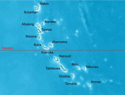
Map of Gilbert Islands, Kiribati
Geography
The atolls and islands of the Gilbert Islands are arranged in an approximate north-to-south line. As the crow flies it is approximately 420 nautical miles (780 km) between the northernmost island, Makin, and the southernmost, Arorae. In a geographical sense, the equator serves as the dividing line between the northern Gilbert Islands and the southern Gilbert Islands. The International Hydrographic Organization (IHO) considers the Gilberts wholly within the South Pacific Ocean, however.
Another method of grouping the Gilbert Islands is by former administrative districts, the Northern, Central, and Southern Gilberts (Tarawa once was a separate district as well).
A group of the southern Gilberts is called the Kingsmill Group, a name that in the 19th century applied to all of the Gilberts.
The Gilberts form a continuous chain of seamounts with the Ratak Chain of the Marshall Islands to the north.
Islands of the Gilberts
In official north-south order (grouped by former administrative districts), the islands and atolls are:
Northern Gilberts
The Northern Gilberts (mweang) geographically and traditionally encompass Butaritari, Makin, Marakei, Abaiang (literally northland) and Tarawa. They have unique tonal accents with differences particularly noted amongst Butaritari and Makin inhabitants. Traditionally, Butaritari and Makin were ruled by a chief who lived on Butaritari Island. This chief had all the powers and authority to make and impose decisions on the islanders, a system very different from the Southern Gilbert Islands where power was wielded collectively by the unimwane or old men of the island.
The northern Gilberts have a greater mean rainfall in comparison to the southern and central Gilberts allowing cultivation of a wider crop range. Butaritari and Makin supply most of the bananas sold in Kiribati. The cultivation of taro or babai (Colocasia esculenta) has been historically easier in the northern Gilberts due to a higher water table and regular rainfall.
Central Gilberts
The Central Gilberts or nuka have traditionally included Maiana, Abemama, Kuria and Aranuka. However, the latter three are considered the main islands that have unique historical and cultural characteristics which distinguish the Central Gilberts from the north and south.
Tembinok', the last king of Abemama, Kuria and Aranuka died in the early part of the 20th century.
Southern Gilberts
The Southern Gilberts include the atolls of Nonouti, South and North Tabiteuea, Beru, Nikunau, Onotoa, Tamana and the most southerly island of Arorae.
Prehistory
The islands had been inhabited by Micronesians for several millennia (at least 2,000 years, probably 3,000).
Contact with other cultures
In 1606 Pedro Fernandes de Queirós sighted Butaritari and Makin, which he named the Buen Viaje (‘good trip’ in Spanish) Islands.
Captain John Byron passed through the islands in 1764 during his circumnavigation of the globe as captain of HMS Dolphin.
In 1788 Captain Thomas Gilbert in Charlotte and Captain John Marshall in Scarborough crossed through Abemama, Kuria, Aranuka, Tarawa, Abaiang, Butaritari, and Makin without attempting to land on the atolls.
Further exploration
In 1820, the islands were named the Gilbert Islands or îles Gilbert (in French) by Adam Johann von Krusenstern, a Baltic German admiral of the Czar after the British Captain Thomas Gilbert, who crossed the archipelago in 1788. French captain Louis Duperrey was the first to map the whole Gilbert Islands archipelago. He commanded La Coquille on its circumnavigation of the earth (1822–1825).
Two ships of the United States Exploring Expedition, USS Peacock (1828) and USS Flying Fish (1838), under the command of Captain Hudson, visited many of the Gilbert Islands (then called the Kingsmill Islands or Kingsmill Group in English). While in the Gilberts, they devoted considerable time to mapping and charting reefs and anchorages.
Colonial rule
A British protectorate was first proclaimed over the Gilberts by Captain Davis of HMS Royalist (1883) on 27 May 1892. British official Arthur Mahaffy visited the Islands in 1909. He noted that the "villages are kept in admirable order and the roads are scrupulously clean." A hospital was on each island, as well. The conduct of W. Telfer Campbell, the resident commissioner of the Gilberts was criticised as to his legislative, judicial and administrative management (including allegations of forced labour exacted from islanders) and became the subject of the 1909 report by Arthur Mahaffy. In 1913 an anonymous correspondent to the New Age journal described the mis-administration of W. Telfer Campbell and questioned the partiality of Arthur Mahaffy as he was a former colonial official in the Gilberts.
In 1915, the Gilbert and Ellice Islands were proclaimed a colony of the British Empire.
Population
The natives of the Gilbert Islands are Micronesian, similar in many respects to the natives of the Marshalls, the Carolines, and the Marianas.
In Mahaffy's 1909 report to the British Government he described the missionaries or Protectorate staff then resident in the Gilbert Islands.
At the outbreak of World War II, about 78% of the native population were said to be Christians. This group was divided mainly into two denominations: Congregationalists (43%) and Roman Catholics (35%). The rest of the population were largely semi-pagan agnostics; they did not adhere to the Christian faith, nor did they retain much of their beliefs in their own ancient gods.
Native diet during this time consisted mainly of fish, coconuts, pandanus fruit, babai (swamp taro), chicken, and some pork. Housing for Europeans employed in the island was simple: constructed of European and native materials and generally of the bungalow type. Mahaffy described the native clothing as being of "shocking shape" and "atrocious color," and that the style was changing into "kilt(s) of leaves or fine woven mats."
Economy
In the early to mid 20th century the principal source of income for Gilbert islanders was from working on the production of phosphate from the deposits on Banaba (Ocean Island), an island to the west of the Gilbert Islands. In addition, coconut palms were cultivated on some of the islands. All labor was supervised by the British and every effort was made to see that the wages and living conditions were fair and adequate. Sanitary inspections by the British did much to improve the general living conditions on most of the islands.
Mahaffy noted in 1909 that "extreme poverty is virtually unknown," and that most people on the island owned their own land. Residents paid taxes, with the majority of taxes going back into the community, and a small portion going to the Protectorate.
Administration
Judged to be about 84% literate, the Gilbertese responded readily to the colony's educational efforts. All education in the islands came under the supervision of the Colonial Education Department whose aims were to educate native boys for employment in government and commercial work, and to standardize the level of education throughout the colony. The bulk of the education was provided by the missions, which maintained all the village schools and trained the native school teachers.
With the availability of European-style medical care life improved. The Phoenix Islands Settlement Scheme sought to provide an outlet through the development of three uninhabited atolls in the Phoenix Islands and was the last attempt at human colonization within the British Empire.
Religion
Hiram Bingham II (1831–1908) was the first to translate the Bible into Gilbertese, and also wrote hymns for the Gilbertese language. Joanna Gordon-Clark writes of their religious belief:
The Gilbert (and Ellice) Islanders had a strong set of beliefs of their own, pre the Christian missionaries; they had a strong foundation myth, involving trees and the two genders. Their ancestors, they said, had been white skinned and red haired and came from elsewhere, perhaps the West (possibly coinciding with the outward spread of Homo sapiens from Africa and elsewhere). As might be expected, they gave power to the natural forces and gave them names and godly characteristics (sun, moon, etc.) but believed in one spirit god, a bit similar to the god of Genesis, in that he/she seemed to have power over dark and light and so on, and was pretty much invisible. They had a strong belief in behaving properly to their ancestors, and especially their parents, and had well-developed community rules for courtesy to others. Read A Pattern of Islands, by Arthur Grimble, who worked in these islands and on Banaba, for the Colonial Administration, from just before the First World War to the mid thirties, or thereabouts. It is a remarkable, informative, funny and warm-hearted account of these people and their religion. Other religions on the islands figure slightly, and there are remarkable stories of adventures, bravery, political machinations, etc. Probably out of print, but second hand copies are available I think, I have two, and the illustrations are delightful.
The Second World War
On the same day as the attack on Pearl Harbor, the Japanese invaded the Gilbert Islands, occupying them by 10 December 1941.
On 17 August 1942, 221 U.S. Marines of the 2nd Marine Raider Battalion raided Makin from two submarines. The raid was intended by the Americans to confuse the Japanese about US intentions in the Pacific. It is instead believed to have alerted the Japanese to the strategic importance of the Gilbert Islands and led to their reinforcement and fortification. Marines captured during this operation were subsequently summarily executed by the Japanese, in gross violation of the laws of war. The 19 Marines who died were left behind for the villagers to bury. In 1999, a Marine Honor guard was sent to recover the bodies and found them after a villager showed them where to dig. All were exhumed and were taken to the United States.
Tarawa and Abemama were occupied in force by the Japanese in September 1942 and during the next year garrisons were built up on Betio (Tarawa Atoll), and Butaritari (Makin Atoll). Only nominal forces were placed on other islands in the Gilberts.
On 20 November 1943, the United States Army and U.S. 2nd Marine Division landed on Makin and Tarawa, initiating the battles of Makin and Tarawa, in which the Japanese were defeated. The Gilbert Islands were then used to support the invasion of the Marshall Islands in February 1944.
Self-determination
The Gilbert and Ellice Islands became autonomous in 1971. From 1976 to 1978, the Ellice Islands were separated, and the Gilberts became the Gilbert Islands colony, which issued stamps under that name. In 1979, the Gilberts opted for independence, becoming the independent nation of Kiribati. The Ellice Islands became the independent nation of Tuvalu.