
Elevation 10,223 ft (3,116 m) Country United States of America | ||
 | ||
Similar Tobacco Root Mountains, Table Mountain, Rocky Mountains, Flint Creek Range, Snowcrest Range | ||
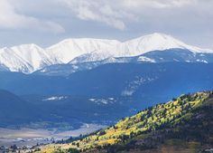
The Highland Mountains, highest point Table Mountain, el. 10,223 feet (3,116 m), are a small mountain range southwest of Whitehall, Montana in Silver Bow and Madison County, Montana.
Map of Highland Mountains, Montana 59754, USA
The Continental Divide winds through the range. A 21,000-acre roadless area encompasses the core of the range, which includes Red Mountain, also over 10,000'. Nutritious alpine forage in the Highlands gives area bighorn sheep the fastest horn growth of any herd in Montana. The green-tinted waters of Emerald Lake provide a nice contrast to the red rock of Red Mountain. A smaller roadless area of about 10,000 acres in the Basin Creek drainage protects Butte's municipal watershed. Lodgepole pine and Douglas-fir are common tree species.
References
Highland Mountains Wikipedia(Text) CC BY-SA