
Isolation 19.3 miles (31.1 km) Elevation 3,113 m | Parent range Highland Mountains Prominence 1,348 m | |
 | ||
Similar Hilgard Peak, Mount Satima, Crazy Peak, McDonald Peak, Snowshoe Peak | ||
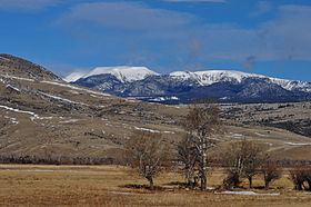
Table Mountain, el. 10,213 feet (3,113 m) is the highest peak in the Highland Mountains in Madison County, Montana. It is located in Deerlodge National Forest. Headwaters of Moose Creek, Fish Creek and Hell's Canyon Creek, all significant tributaries of the Jefferson River flow off the face of the mountain.
Map of Table Mountain, Montana 59754, USA
References
Table Mountain (Madison County, Montana) Wikipedia(Text) CC BY-SA