
Tenure 1415–1460 Successor Fernando I | Burial Batalha Monastery Name Henry Navigator Nationality Portuguese | |
 | ||
Siblings Edward, King of Portugal, Peter, Duke of Coimbra Parents Philippa of Lancaster, John I of Portugal Cousins Henry V of England, Philippa of England, John of Lancaster - 1st Duke, Humphrey - Duke of Gloucester, Thomas of Lancaster - 1st Duke Similar People | ||
Henry the navigator
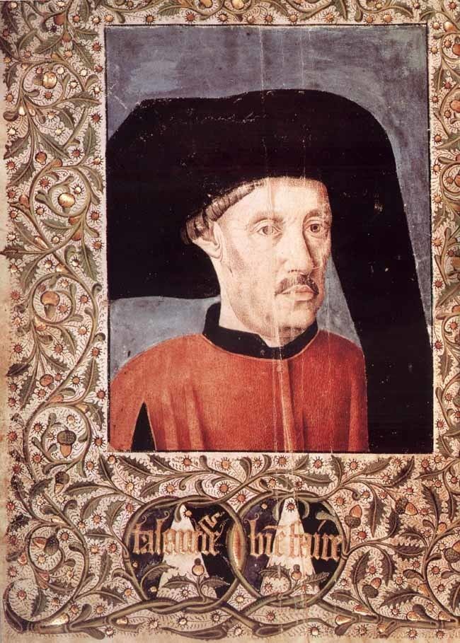
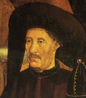
Infante D. Henrique of Portugal, Duke of Viseu (4 March 1394 – 13 November 1460), better known as Prince Henry the Navigator (Portuguese: Infante Dom Henrique, o Navegador), was an important figure in 15th-century Portuguese politics and in the early days of the Portuguese Empire. Through his administrative direction, he is regarded as the main initiator of what would be known as the Age of Discoveries. Henry was the third child of the Portuguese king John I and responsible for the early development of Portuguese exploration and maritime trade with other continents through the systematic exploration of Western Africa, the islands of the Atlantic Ocean, and the search for new routes.
Contents
- Henry the navigator
- Prince Henry the Navigator
- Life
- Vila do Infante and Portuguese exploration
- Henrys explorations
- Madeira
- The Azores
- West African coast
- Origin of the Navigator nickname
- Fiction
- References
King John I was the founder of the House of Aviz. Henry encouraged his father to conquer Ceuta (1415), the Muslim port on the North African coast across the Straits of Gibraltar from the Iberian Peninsula. He learned of the opportunities from the Saharan trade routes that terminated there, and became fascinated with Africa in general; he was most intrigued by the Christian legend of Prester John and the expansion of Portuguese trade. Henry is regarded as the patron of Portuguese exploration.
Prince Henry the Navigator
Life
Henry was the third surviving son of King John I and his wife Philippa, sister of King Henry IV of England. He was baptized in Porto, and may have been born there, probably when the royal couple was living in the city's old mint, now called Casa do Infante (Prince's House), or in the region nearby. Another possibility is that he was born at the Monastery of Leça do Bailio, in Leça da Palmeira, during the same residential passage of the royal couple in the city of Porto.
Henry was 21 when he and his father and brothers captured the Moorish port of Ceuta in northern Morocco. Ceuta had long been a base for Barbary pirates who raided the Portuguese coast, depopulating villages by capturing their inhabitants to be sold in the African slave market. Following this success, Henry started to explore the coast of Africa, most of which was unknown to Europeans. His objectives included finding the source of the West African gold trade and the legendary Christian kingdom of Prester John, and stopping the pirate attacks on the Portuguese coast. At that time, the ships of the Mediterranean were too slow and too heavy to make these voyages. Under his direction, a new and much lighter ship was developed, the caravel, which could sail further and faster, and, above all, was highly maneuverable and could sail much nearer the wind, or "into the wind". This made the caravel largely independent of the prevailing winds. With the caravel, Portuguese mariners explored the shallow waters and rivers as well as the open ocean with wide autonomy. In 1419, Henry's father appointed him governor of the province of the Algarve.
Vila do Infante and Portuguese exploration
According to João de Barros, in the Algarve he repopulated a village that he called Terçanabal (from terça nabal or tercena nabal). This village was situated in a strategic position for his maritime enterprises and was later called Vila do Infante ("Estate or Town of the Prince").
It is traditionally suggested that Henry gathered at his villa on the Sagres peninsula a school of navigators and map-makers. However modern historians hold this to be a misconception. He did employ some cartographers to chart the coast of Mauritania after the voyages he sent there, but there was no center of navigation science or observatory in the modern sense of the word, nor was there an organized navigational center.
Referring to Sagres, sixteenth-century Portuguese mathematician and cosmographer Pedro Nunes remarked, "from it our sailors went out well taught and provided with instruments and rules which all map makers and navigators should know."
The view that Henry's court rapidly grew into the technological base for exploration, with a naval arsenal and an observatory, etc., although repeated in popular culture, has never been established. Henry did possess geographical curiosity, and employed cartographers. Jehuda Cresques, a noted cartographer, has been said to have accepted an invitation to come to Portugal to make maps for the infante. This last incident probably accounts for the legend of the School of Sagres, which is now discredited.
The first contacts with the African slave market were made by expeditions to ransom Portuguese subjects enslaved by pirate attacks on Portuguese ships or villages. As Sir Peter Russell remarks in his biography, "In Henryspeak, conversion and enslavement were interchangeable terms."
Henry's explorations
Henry sponsored voyages, collecting a 20% tax (o quinto) on the profits made by naval expeditions, which was the usual practice in the Iberian states of that time. The nearby port of Lagos provided a convenient harbor from which these expeditions left. The voyages were made in very small ships, mostly the caravel, a light and maneuverable vessel. The caravel used the lateen sail, the prevailing rig in Christian Mediterranean navigation since late antiquity. Most of the voyages sent out by Henry consisted of one or two ships that navigated by following the coast, stopping at night to tie up along some shore.
During Prince Henry's time and after, the Portuguese navigators discovered and perfected the North Atlantic Volta do Mar (the "turn of the sea" or "return from the sea"): the dependable pattern of trade winds blowing largely from the east near the equator and the returning westerlies in the mid-Atlantic. This was a major step in the history of navigation, when an understanding of oceanic wind patterns was crucial to Atlantic navigation, from Africa and the open ocean to Europe, and enabled the main route between the New World and Europe in the North Atlantic in future voyages of discovery. Although the lateen sail allowed sailing upwind to some extent, it was worth even major extensions of course to have a faster and calmer following wind for most of a journey. Portuguese mariners who sailed south and southwest towards the Canary Islands and West Africa would thus sail far to the west—that is, away from continental Portugal, and seemingly in the wrong direction—before turning northeast near the Azores islands and finally east to Europe in order to have largely following winds for their full journey. Christopher Columbus used this on his transatlantic voyages.
Madeira
The first explorations followed not long after the capture of Ceuta in 1415. Henry was interested in locating the source of the caravans that brought gold to the city. During the reign of his father, John I, João Gonçalves Zarco and Tristão Vaz Teixeira were sent to explore along the African coast. Zarco, a knight in service to Prince Henry, had commanded the caravels guarding the coast of Algarve from the incursions of the Moors. He had also been at Ceuta.
In 1418, Zarco and Teixeira were blown off-course by a storm while making the volta do mar westward swing to return to Portugal. They found shelter at an island they named Porto Santo. Henry directed that Porto Santo be colonized. The move to claim the Madeiran islands was probably a response to Castile's efforts to claim the Canary Islands. In 1420, settlers then moved to the nearby island of Madeira.
The Azores
A chart drawn by the Catalan cartographer, Gabriel de Vallseca of Mallorca, has been interpreted to indicate that the Azores were first discovered by Diogo de Silves in 1427. In 1431, Gonçalo Velho was dispatched with orders to determine the location of "islands" first identified by de Silves. Velho apparently got a far as the Formigas, in the eastern archipelago, before having to return to Sagres, probably due to bad weather.
By this time the Portuguese navigators had also reached the Sargasso Sea (western North Atlantic region), naming it after the Sargassum seaweed growing there (sargaço / sargasso in Portuguese).
West African coast
Until Henry's time, Cape Bojador remained the most southerly point known to Europeans on the desert coast of Africa. Superstitious seafarers held that beyond the cape lay sea monsters and the edge of the world. In 1434, Gil Eanes, the commander of one of Henry's expeditions, became the first European known to pass Cape Bojador.
Using the new ship type, the expeditions then pushed onwards. Nuno Tristão and Antão Gonçalves reached Cape Blanco in 1441. The Portuguese sighted the Bay of Arguin in 1443 and built an important fort there around the year 1448. Dinis Dias soon came across the Senegal River and rounded the peninsula of Cap-Vert in 1444. By this stage the explorers had passed the southern boundary of the desert, and from then on Henry had one of his wishes fulfilled: the Portuguese had circumvented the Muslim land-based trade routes across the western Sahara Desert, and slaves and gold began arriving in Portugal. By 1452, the influx of gold permitted the minting of Portugal's first gold cruzado coins. A cruzado was equal to 400 reis at the time. From 1444 to 1446, as many as forty vessels sailed from Lagos on Henry's behalf, and the first private mercantile expeditions began.
Alvise Cadamosto explored the Atlantic coast of Africa and discovered several islands of the Cape Verde archipelago between 1455 and 1456. In his first voyage, which started on 22 March 1455, he visited the Madeira Islands and the Canary Islands. On the second voyage, in 1456, Cadamosto became the first European to reach the Cape Verde Islands. António Noli later claimed the credit. By 1462, the Portuguese had explored the coast of Africa as far as present-day Sierra Leone. Twenty-eight years later, Bartolomeu Dias proved that Africa could be circumnavigated when he reached the southern tip of the continent, now known as the "Cape of Good Hope". In 1498, Vasco da Gama became the first European sailor to reach India by sea.
Origin of the "Navigator" nickname
No one used the nickname "Navigator" to refer to prince Henry during his lifetime or in the following three centuries. The term was coined by two nineteenth-century German historians: Heinrich Schaefer and Gustave de Veer. Later on it was made popular by two British authors who included it in the titles of their biographies of the prince: Henry Major in 1868 and Raymond Beazley in 1895. In Portuguese, even in modern times, it is uncommon to call him by this epithet; the preferred use is "Infante D. Henrique".