
Subregion Algarve Local time Tuesday 3:19 AM | Region Algarve Intermunic. comm. Algarve Population 1,909 (2011) | |
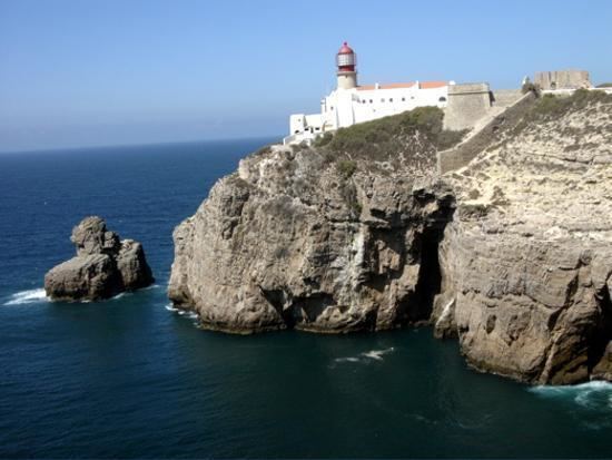 | ||
Weather 9°C, Wind SW at 3 km/h, 96% Humidity Points of interest Cape St Vincent, Sagres Fortress, Praia do Beliche, Lighthouse of Cabo de São Vice, Praia do Tonel | ||
Sagres is a civil parish in the municipality of Vila do Bispo, in the southern Algarve of Portugal. The population in 2011 was 1,909, in an area of 34.37 square kilometres (13.27 sq mi). It is historically connected to the early Portuguese Age of Discovery.
Contents
Map of Sagres, Portugal
History
The name Sagres, follows from Sagrado (holy) owing to the important local religious practices and rituals that occurred during the pre-history of the nation. From here some of the Mediterranean peoples (including the Phoenicians, Greeks, Carthaginians and Romans), venerated their divinities and which some believed, owing to the absence of a human settlement, was the gathering place for their gods. Christinas (Mozarabs) that lived in this zone, during the Muslim occupation, erected the Church of Corvo, where the mortal remains of the saint Vincent were deposited in the 8th century. The presence of martyr's remains lead the Portuguese to refer to the site and the peninsula as the Cape of Saint Vincent.
The area has been intrinsically linked to the nautical school first developed by Prince Henry the Navigator, which was installed in the 15th century. Although born in the provincial city of Porto (1394), he would be connected with his life in the parish, until his death in 1460, being known as the Infante of Sagres. Although there existed a medieval settlement in this area (Terçanabal), all the land was donated on 27 October 1443 to Infante Henry. The prince was associated with the Military Order of Christ, Duke of Viseu, Master of Covilã and a man preoccupied with his signeurial holdings and defense of his faith. Henry obtained his wealth from the lands he held and the fisheries in the Algarve, and therefore preoccupied himself with needs of his workers, both materially and spiritually, and therefore invested in the founding of a village (later known as the Vila do Infante) to assist the population. The fortified town was situated on the Ponta de Sagres, a strategic point dominated the coves of Mareta and Beliche. Henry's controlled his material interests from his villa, located on the clifftops, and when he died on 13 November 1460, the Portuguese navigators and other services, had already reached Sierra Leon.
Sagres was created in 1519, through the division of the municipality of Vila do Bispo.
King Sebastian was known to have spent time in the parish, listening to music along the cliffs and the sea. A chronicle of the 16th century, referred to the young Kings stay at the Convent of São Vicente do Cabo, and later, locals recounted that King was enchanted by the landscape of Sagres.
In May 1587, Francis Drake (one of more notable adventurers and military officers in the Court of Elizabeth) disembarked 800 men who assaulted the fortress of Sagres. After two hours of intense combat, fortifications adjacent to the fortress were destroyed and its artillery was pillaged.
Until 1834, Sagres was an independent municipality, consisting of little more than 413 inhabitants.
Geography
Sagres is located in the extreme southwest of continental Europe, and marked by two geomorphological structures: the Cape St. Vincent and Sagres Point, which establish a transition between the eastern coastal and meridional zones. Exposed to the Atlantic Ocean, it is influenced by Mediterranean currents, marked by promontories of high cliffs leading onto a platform that oscillates between 100–200 metres (330–660 ft) (in the north) and 50 metres (160 ft)). Whether by coastal erosion, or the hard rock, its composition influences the relief of the area.
At 157 meters high, Torre de Aspa is a viewpoint on the western side of Vila do Bispo, which offers a panoramic view of Sagres and São Vicente Cape.