
Country United States County Kern County Elevation 956 m | State California Reference no. 100 Local time Friday 11:26 PM | |
 | ||
Weather 14°C, Wind SE at 6 km/h, 59% Humidity | ||
Havilah is an unincorporated community in Kern County, California. It is located in the mountains between Walker Basin and the Kern River Valley, 5 miles (8.0 km) south-southwest of Bodfish at an elevation of 3136 feet (956 m).
Contents
Map of Havilah, CA 93518, USA
Early
Asbury Harpending arrived in the area with a group of Confederate sympathizers in 1864. After finding gold deposits on Clear Creek, a tributary of the Kern River, the group claimed a townsite on the road from Keyesville to Tehachapi and named it after the Biblical land of Havilah, "where there is gold" according to Genesis 2:11. By the end of 1865, Havilah was a boom town with 147 business buildings, thirteen saloons, and a population of nearly a thousand, mostly miners working the Clear Creek Mining District.
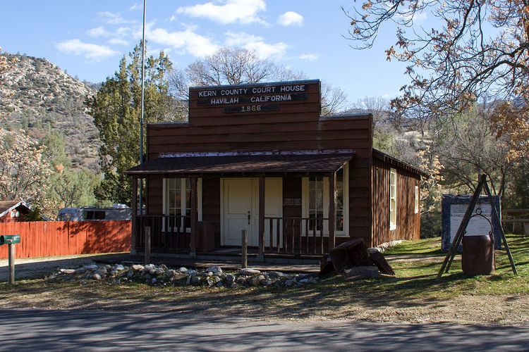
Havilah was the county seat at the founding of Kern County on April 2, 1866, and the county's first newspaper, the Havilah Courier, began publication that same year. The county government was moved to Bakersfield in 1874.
A post office operated at Havilah from 1866 to 1918. The Havilah School District, formed in 1866, was the first public school in Kern County.
Nearby historic mining communities include Loraine, (originally named Paris) and Twin Oaks. The town is now registered as California Historical Landmark #100.
Today
Aside from the Old Havilah Cemetery, little remains from the original settlement, most of which was destroyed by fires in the 1920s. A replica of the courthouse and one-room schoolhouse have been constructed near their original locations. The sides of Caliente-Bodfish Road in Havilah are lined with signs marking where other historic buildings once stood.
Accessible by car, Havilah is just over 20 miles (32 km) driving distance from the intersection of State Route 58 and Caliente-Bodfish Road. It is just over five driving miles from Bodfish on Caliente-Bodfish Road. There is a local tradition among drivers on Caliente-Bodfish Road: every driver waves at the driver of every other passing vehicle.
A US Forest Service service center is situated along Caliente-Bodfish Road at 35°30′38″N 118°31′06″W.
US Geological Survey plots several mines nearby. Names of local mines include:
Districts, zones, boundaries, and services
The ZIP Code is 93518, and the community is inside area code 661. Havilah shares its postal ZIP Code with the nearby communities of Caliente and Loraine. The community is within the Kern County Air Pollution Control District.
The area is bordered to the east and west by Sequoia National Forest lands and is located at the junction of Havilah Canyon and Haight Canyon. Elevations at the floor of the canyon range from approximately 3,050 feet (930 m) AMSL to 3,400 feet (1,000 m). Havilah Canyon runs roughly north-south and mountain peaks to the east and west are over 1,000 feet (300 m) higher than the roadway, which runs along the floor of Havilah Canyon. King Solomons Ridge lies to the east; Hobo Ridge lies to the west. Snow may be present during winter months.
The community falls within the Battalion 7 area of the Kern County Fire Department. It is listed by the California Fire Alliance as being at high risk to wildfire.
Commercial electric power is supplied by Southern California Edison.