
Area rank 17 in Norway Area 2,684 km² Local time Saturday 3:08 AM | Administrative centre Hattfjelldal Demonym(s) Hattfjelldaling Population 1,463 (2011) Official language form Norwegian Language | |
 | ||
Weather -3°C, Wind W at 14 km/h, 83% Humidity | ||
Hattfjelldal (Southern Sami: Aarborte and Northern Sami: Árbordi) is a municipality in Nordland county, Norway. It is part of the Helgeland traditional region. The administrative centre of the municipality is the village of Hattfjelldal. Other villages include Grubben, Svenskvollen, and Varntresk. Hattfjelldal Airfield is located in the village of Hattfjelldal.
Contents
- Map of 8690 Hattfjelldal Norway
- General information
- Name
- Coat of arms
- Churches
- Geography
- Government
- Municipal council
- References
Map of 8690 Hattfjelldal, Norway
Hattfjelldal is one of the last strongholds for the seriously endangered Southern Sami language.
Hattfjelldal was one of the municipalities in Norway involved in the Terra Securities scandal.
General information
The municipality of Hattfjelldal was established in 1862 when it was separated from the large municipality of Vefsn. The initial population of Hattfjelldal was 961. On 1 January 1964, the part of Hattfjelldal on the north side of the lake Røssvatnet (population: 168) was transferred to Hemnes.
Name
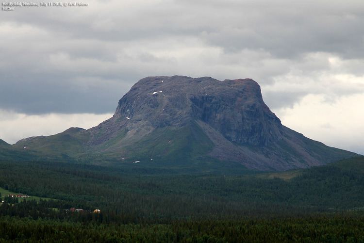
The municipality (originally the parish) is named after the old Hattfjelldalen farm (named "Hatfieldalen" in 1723), since the first church was built there. The first element is the name of the mountain Hattfjellet and the last element is dal which means "valley" or "dale". The meaning of the name Hattfjellet is "the hat mountain" (because its shaped like a hat).
Coat-of-arms
The coat-of-arms is from modern times; they were granted on 24 October 1986. The arms show the Hattfjellet mountain, with its typical shape. The mountain is a canting element since the name of the municipality means "hat mountain valley".
Churches
The Church of Norway has one parish (sokn) within the municipality of Hattfjelldal. It is part of the Indre Helgeland deanery in the Diocese of Sør-Hålogaland.
Geography
Hattfjelldal lies along the Swedish border in the southeastern part of Nordland county. The lake Røssvatnet (Southern Sami: Reevhtse) lies on the border between Hattfjelldal and Hemnes, and it serves as a reservoir. It has been the site of human occupation since the Stone Age. Its area of 219 square kilometres (85 sq mi) makes it the second largest lake in Norway by surface area.
Other lakes in the region include Daningen, Elsvatnet, Famnvatnet, Jengelvatnet, Kjerringvatnet, Krutvatnet, Ranseren, Simskardvatnet, and Unkervatnet. The large river Vefsna runs through the municipality.
Børgefjell National Park is partly located in the southern part of Hattfjelldal, as is Jetnamsklumpen, a prominent mountain. There is several nature reserves, such as Varnvassdalen with a varied topography and old growth forest of pine, birch and some spruce.
Government
All municipalities in Norway, including Hattfjelldal, are responsible for primary education (through 10th grade), outpatient health services, senior citizen services, unemployment and other social services, zoning, economic development, and municipal roads. The municipality is governed by a municipal council of elected representatives, which in turn elect a mayor.
Municipal council
The municipal council (Kommunestyre) of Hattfjelldal is made up of 17 representatives that are elected to every four years. Currently, the party breakdown is as follows: