
Surface elevation 383 m Mean depth 67 m Shore length 256.4 km | Average depth 67 metres (220 ft) Area 218.6 km² Volume 14.8 km³ | |
 | ||
Surface area 218.61 km (84.41 sq mi) Max. depth 240 metres (790 ft)(231 m before damming) Water volume 14.80 km (3.55 cu mi)(12.60 km³ before damming) Reference Norwegian Water Resources and Energy Directorate | ||
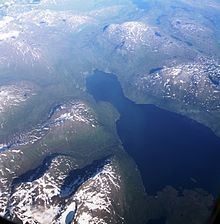
Røssvatnet (Southern Sami: Reevhtse) is a lake and reservoir in the municipalities of Hattfjelldal and Hemnes in Nordland county, Norway. It has been the site of human occupation since the Stone Age. Its area of 219 square kilometres (85 sq mi) makes it the second largest lake in Norway by surface area. Without the dam which has regulated the lake since 1957, it would be 190 square kilometres (73 sq mi) and the third largest lake in Norway. Its depth is 240 metres (790 ft), its volume is estimated at about 15 cubic kilometres (3.6 cu mi), and its surface elevation is 374 metres (1,227 ft) above sea level.
Map of R%C3%B8ssvatnet, Norway
References
Røssvatnet Wikipedia(Text) CC BY-SA