
Status Operating Character Commuter rail Stations 38 | System Metro-North Daily ridership 43,076 | |
 | ||
Termini | ||
Metro north harlem line timelapse grand central to southeast
Metro-North's Harlem Line, originally chartered as the New York & Harlem Railroad, is an 82-mile (132 km) commuter rail line running north from New York City into eastern Dutchess County. The lower 53 miles (86 km) from Grand Central Terminal to Southeast, in Putnam County, is electrified with a third rail and has two (or more) tracks; north of that point, trains use diesel locomotives on a single track. The diesel trains run as a shuttle on the northern end of the line except during rush hours, when they run as expresses to or from Grand Central. There is also one direct roundtrip to Grand Central on weekends. While the line has traditionally served to bring commuters from Westchester County to jobs in the city, in recent years it has begun to see more "reverse commuting", as Bronx residents use it to reach jobs in Southern Westchester where many stations are within walking distance of city centers. The northern reaches of the line are also close enough to Western Massachusetts to enable residents of part of that region to commute to jobs in the city as well.
Contents
- Metro north harlem line timelapse grand central to southeast
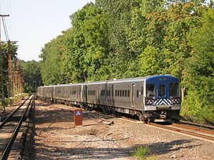
- Mta metro north harlem line trains at valhalla ny rr
- History
- Line description
- Manhattan Bronx
- Westchester County
- Putnam County
- Dutchess County
- Improvements
- Future
- Branches
- Rolling stock
- Lake Mahopac Branch
- Port Morris Branch
- References
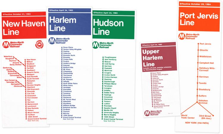
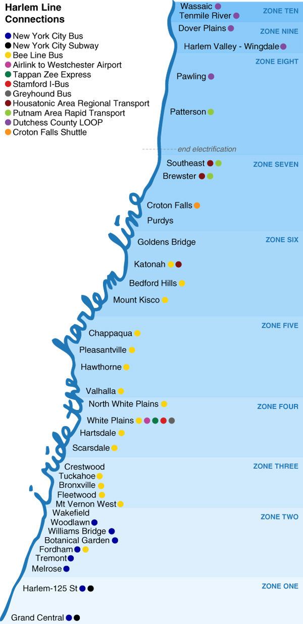
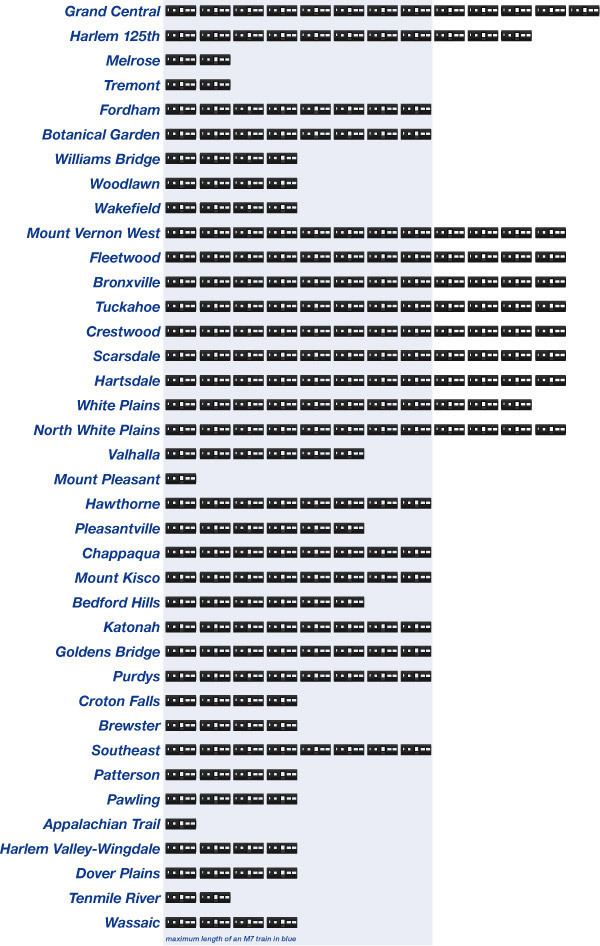
With 38 stations, the Harlem Line has the most of any Metro-North main line. Its northern terminal, Wassaic, is the northernmost station in the system. It is the only Metro-North line used exclusively by that carrier (no use by Amtrak, though CSX services freight customers as far north as Mount Vernon) and the only one that uses the entirety of existing track. Metro-North has assigned it the color code blue, used as trim on station signs and spot color on printed timetables. The blue color-coding appears to have started with timetables issued by predecessor New York Central as far back as 1965.
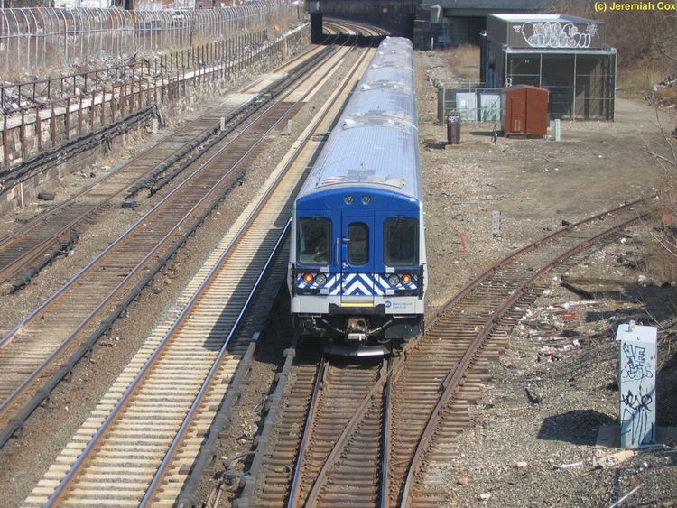
Mta metro north harlem line trains at valhalla ny rr
History
Prior to becoming part of the Metro-North system, the line continued all the way north to Chatham, New York, where connections could be made for Albany to the west or Boston to the east on the Boston and Albany Railroad. Additional connections could be made to railroads serving North Bennington, Vermont and other points in western Vermont. Chatham is about 52 miles past the current terminal at Wassaic. In Boston Corners, about 12 miles north of Wassaic, passengers could make connections to the Central New England Railroad. To the east, the CNE went to Hartford, Connecticut. Westward, passengers could travel to Poughkeepsie, cross the Poughkeepsie Bridge, finally to Campbell Hall.
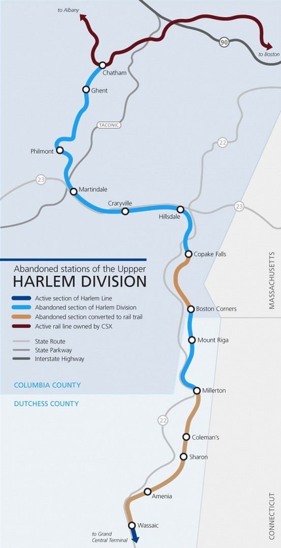
Passenger service from Dover Plains to Chatham was abandoned in 1972, as well as 138th Street, Morrisania, and 183rd Street stations in the South Bronx, and Holland Avenue station in White Plains, although that one was replaced. Penn Central operated the last southbound passenger train between Chatham and Grand Central Terminal on March 20, 1972, ending service in the middle of the day. With no scheduled return trip to Chatham, passengers who had gone south in the morning were left stranded, with service going only as far north as Dover Plains (52 miles shy of Chatham). Tracks were removed north of Millerton shortly thereafter.
The Metropolitan Transportation Authority (MTA) leased the line south of Dover Plains from Penn Central on June 1, 1972. In 1980, freight service between Dover Plains and Millerton was abandoned, with tracks removed from Wassaic to Millerton. On July 9, 2000, Metro-North restored service between Dover Plains and Wassaic, a move the railroad billed as its first service expansion since it was created in 1983.
The segment of the line that ran from Wassaic to Craryville, New York is now under control of the Harlem Valley Rail Trail Association, which currently has trails operating from Wassaic to the former Millerton station and between Under Mountain Road and Copake Falls, known as the Harlem Valley Rail Trail.
On February 3, 2015, a Harlem line train struck a car on the tracks near Valhalla and caught fire. Seven people were killed and service was suspended between Pleasantville and North White Plains.
Line description
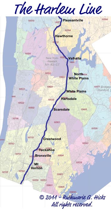
The Harlem Line hews closely to roads along river-based transportation corridors dating back to even pre-rail times. It follows three major parkways closely from the Bronx northwards through Westchester: the Bronx River Parkway (and a short portion that becomes the Taconic State Parkway), the Saw Mill River Parkway and Interstate 684. In the last section it also begins to run close to NY 22, the long north-south two-lane state highway that parallels the eastern border of the state.
In Westchester, it serves some of that county's most affluent communities as it slowly trends eastward.
Manhattan / Bronx
The Harlem Line begins at Grand Central Terminal. The train tracks rise to ground level north of 97th Street in Manhattan. After stopping at Harlem – 125th Street, the Harlem Line crosses the Harlem River at 135th Street in Manhattan, entering the Bronx.
In the Bronx, the Harlem Line cuts through the neighborhoods of the southwest Bronx, with two stations: Melrose, at 162nd Street (it then runs under the Cross Bronx Expressway (I-95) and Tremont, at 177th Street. Fordham station is next, at Fordham Road (190th Street). The Harlem Line then parallels the western edge of Fordham University until the Botanical Garden station at Bedford Park Boulevard (200th Street).
The Harlem Line then cuts northeast to join the Bronx River Parkway, which lies to the east of the tracks. The Williams Bridge station is next, at Gun Hill Road (210th Street). After the Williams Bridge station, Woodlawn Cemetery begins to the west of the tracks, with Webster Avenue in between the cemetery and tracks. The Woodlawn station is at 233rd Street.
The Harlem Line then goes under a bridge for the parkway, and it remains to the west of the tracks until Scarsdale station. The Wakefield station at 241st Street concludes the Bronx portion of the Harlem Line.
Westchester County
The Westchester portion of the Harlem Line begins at Bronx River Road in southeastern Yonkers. After the Mount Vernon West station, the Harlem Line runs along the on-ramp to the Cross County Parkway eastbound, right before Fleetwood station. After the Bronxville station, the Harlem Line parallels the Bronx River Parkway all the way up to White Plains.
From White Plains, the railroad winds its way through the city and passing through the yards at North White Plains which until 1984 was the northern boundary of third-rail electrification. The stretch north of North White Plains is unique because it is the only third-rail electrified stretch of Metro-North's network that has grade crossings, a byproduct of its existence pre-electrification. Katonah and Brewster are located right next to grade crossings.
After North White Plains, the next station is Valhalla adjacent to the Taconic State Parkway. The double-track railroad then curves to follow the Saw Mill River Valley and the eponymous parkway. Rail and road briefly separate at Mount Kisco, but then remain close by at the last stop along the Saw Mill, Bedford Hills (although the parkway cannot be seen from the station).
Past Katonah, the railroad runs between the Croton River and I-684. Golden's Bridge and Purdy's are both located very close to the interstate, although only the former can be seen from it. North of the latter, the tracks follow the river to Croton Falls, and pick up Route 22 for the first time.
Putnam County
After Croton Falls station, the Harlem Line runs along East Branch Reservoir and crosses into Putnam County and its rural landscape. Above Southeast station (formerly Brewster North), the railroad passes under Interstate 84 and through the yards at Putnam Junction. This is the northern boundary of third rail electrification. Diesel territory and single track begins here. The track finally follows its own course, away from any road or river, past the abandoned Towners station up to Patterson and into Dutchess County.
Dutchess County
Shortly before reaching Pawling, the line enters the Harlem Valley from which it takes its name and begins to parallel Route 22, although not as closely as it did the roads further south. A few miles north of Pawling the Appalachian Trail crossing has earned its own stop to allow thru-hikers to take a break in the city and day hikers to visit the nearby Pawling Nature Preserve.
The next two stops, Harlem Valley – Wingdale and Dover Plains, are roughly eight miles (13 km) apart, the longest distance between any two stops on the Harlem Line. Until 2000, Dover Plains was the last stop on the line, but then tracks remaining from the NYCRR era that had not yet been torn up were renovated and the line was extended to Tenmile River and its new northern terminus, Wassaic. A small yard where diesel trains await their routes just past the station marks the end of the line.
Improvements
Metro-North electrified the territory north of North White Plains to Southeast in 1984, which resulted in tremendous ridership growth. Prior to this, the line was operated primarily in two zones: electric south of North White Plains, and diesel through-service or RDC shuttle service north. With electrification completed, service north of Southeast is now operated as either diesel shuttle or through service. Although service to Wassaic is separately stated in the Harlem Line timetable and is publicly referred to as the "Wassaic Branch", it is operationally part of the main line.
Future
With the entire existing track in use since service to Wassaic was restored in 2000, there is little talk of expansion or branching. For now, Metro-North and the MTA have focused on improving existing facilities on the line, particularly stations such as Brewster where increasing usage has caused parking shortages.
Branches
The Harlem Line currently has no operational branches. Under New York Central ownership, it previously operated a 7.22 mi (11.62 km) branch to Lake Mahopac, NY to a connection with the Putnam Division. This line was originally a subsidiary known as the New York and Mahopac Railroad (1871-1880), and had one station between the two lines in Lincolndale. After the discontinuance of passenger service on the Putnam Division in 1958, the Central operated a shuttle service known as "around the horn" which continued on Putnam Division trackage north of Lake Mahopac to Mahopac, Carmel, and Brewster where it reconnected with the Harlem Division main line. This service lasted until 1959. The only active remnant of this branch is a wye north of Brewster station known as Putnam Junction. There are some remains of the right-of-way of the branch, including a bridge just west of the Golden's Bridge station, which is listed on the National Register of Historic Places.
North of Brewster is a connection with Metro-North's Beacon Line, which was purchased by Metro-North for preservation for future use. There are currently no plans for branch service on this line, which runs north and west to Hopewell Junction, and then south and west to Beacon. It also runs east to Danbury, but a reverse move would be required.
In the opposite direction, there was the freight-only Port Morris Branch. This was part of a line which was originally part of the Spuyten Duyvil and Port Morris Railroad which was established in 1842. The railroad was bought by the New York and Harlem Railroad in 1853, and the segment north of Mott Haven Junction became part of the NYC Hudson Division. The Port Morris Branch began at a wye north of Melrose Station, then extended southeast through The Hub, through a tunnel under St. Mary's Park, and finally Port Morris along the East River just after crossing a bridge beneath the Harlem River and Port Chester Branch of the New York, New Haven and Hartford Railroad. The only two stations along this branch were at Westchester Avenue between Brook and St Mary's Avenues and at Port Morris itself across the river from North Brother Island. This partly electrified branch was abandoned about 1999.
Rolling stock
On the electrified portions of the line, M3As and M7As are usually used. As with the Hudson Line, diesel-powered trains are driven by dual-mode Genesis and BL20-GH locomotives, paired with Shoreliner coaches. While some peak-period trains operate directly to and from Grand Central Terminal, most Harlem Line diesel-only territory is operated as shuttle service between Southeast (where electrification ends) and Wassaic, 29 miles (47 km) north in Dutchess County.
Lake Mahopac Branch
Built by the New York and Mahopac Railroad in 1871; The entire branch was abandoned on April 2, 1959.
Port Morris Branch
The entire line was in the Bronx, used exclusively for freight, and formally abandoned in 2004.