
 | ||
A haor (Bengali: হাওর) is a wetland ecosystem in the north eastern part of Bangladesh which physically is a bowl or saucer shaped shallow depression, also known as a backswamp. In a country where one third of all area can be termed as wetlands, the haor basin is an internationally important wetland ecosystem, which is situated in Sunamganj, Habiganj and Moulvibazar districts and Sylhet Sadar Upazila, as well as Kishoreganj and Netrokona districts outside the core haor area. It is a mosaic of wetland habitats, including rivers, streams and irrigation canals, large areas of seasonally flooded cultivated plains, and hundreds of haors and beels. This zone contains about 400 haors and beels, varying in size from a few hectares to several thousand hectares.
Contents
- Hakaluki haor
- Haor baor beel and jheel
- Geography and geology
- Climate and floods
- Environment
- Conservation
- Migratory birds
- Human habitation
- Economy
- Tourism
- References
Hakaluki haor
Haor, baor, beel and jheel
In Bangladesh, which lies in the floodplain of three great rivers, the Bengali language has several terms to differentiate between lakes, including baor, haor, jheel and beel. All four are types of similar freshwater wetlands. The word haor is a regional variation derived from the Bengali word sagor meaning sea. In parts of Bangladesh, people often pronounce the Bengali alphabet স (sa) as হ (ha), and sometimes গ (ga) as হ (ha). Thus, sagor has become haor.
The line of difference between an haor, a beel and a baor is usually very thin. A beel is usually a depression or topographic low generally produced by erosion or other geographical process. These are generally smaller and seen all over Bangladesh. These are marshy in character. Sometimes beels are remains of a river that has changed its course. Many of the beels dry up in the winter but during the rains expand into broad and shallow sheets of water, which may be described as fresh water lagoons. Beels are generally smaller than haors, but there also are large beels like Chalan Beel in Rajshahi Division, through which the Atrai River passes. It has shrunk over the years but still occupies an area of 26 km2 in dry season. Sometimes small permanent water bodies within the haors remain after the haors dry up. These are also called beels, which occupy the lowest part of the depressions.
A baor is an oxbow lake, found mostly in the moribund delta as in greater Comilla, Faridpur, Dhaka and Pabna districts. The haor is predominantly a feature of north-eastern Bangladesh.
Geography and geology
The core haor area, alternatively referred to as the Haor basin or the Sylhet basin, is estimated to spread over an area between 4,450 km2 and 25,000 square kilometres by experts. The total area of haor-type wetland ecosystem in Bangladesh is 80,000 square kilometres. The haor basin is bounded by the hill ranges of India – Meghalaya on the north, Tripura and Mizoram on the south, and Assam and Manipur on the east. The basin extends north to the foot of the Garo and Khasia Hills, and east along the upper Surma Valley to the Indian border. The Tippera surface lies directly to the south of the Haor Basin, and is partly low and deltaic and partly higher ground with a piedmont fringe to the east. It includes about 47 major haors and some 6,300 beels of varying size, of which about 3,500 are permanent and 2,800 are seasonal.
In the geological depression of the haor basin, subsidence is continuing at an estimated rate of 20 mm per year. In some places it has sunk by around 10 m in the last few hundred years. The area, by some experts, is further divided into three zones by standards of morphology and hydrology:
Soil within the same haor system can vary in texture, drainage class, fertility, and other parameters. The transition from the wettest to the driest areas in the floodplains occurs over distances varying from several kilometers to several meters.
Climate and floods
The haor basin is a remote and difficult area that is flooded every year during monsoon. The climate of the area is subtropical monsoonal with an average annual rainfall of approximately 4,000 mm. Over 80% of the rain falls during the monsoon season from June to October. Temperatures normally vary between 26 and 31 °C in the pre-monsoon period (March to May), 28 to 31 °C in the rainy season, and 26 to 27 °C in winter.
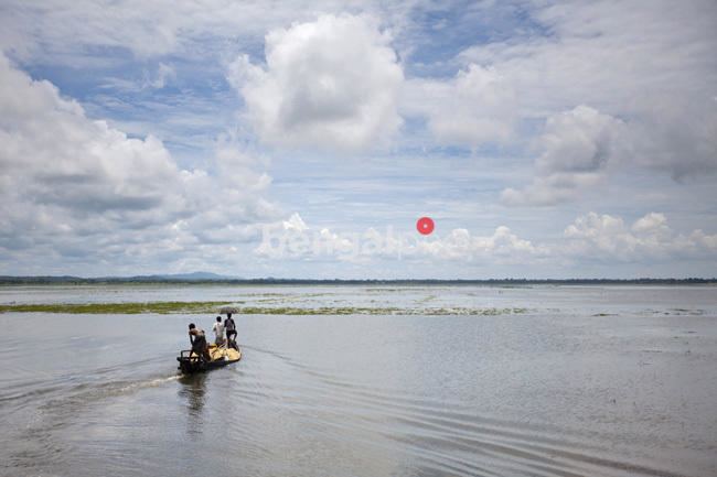
Some of the most extensive seasonally flooded areas in South Asia are situated in bowl-shaped depressions known as haors located between the natural levees of rivers subject to overflow during the monsoon. The major rivers in the area are Surma and Kushiyara. Some of the tributaries are: Manu, Khowai, Jadukhata, Piyain, Mogra, Mahadao and Kangsha. These form the dense drainage network of the haors. The rivers are primarily responsible for providing inputs - rainwater and sediment load to the basin. The hilly rivers coming down from the Khasi and Jaintia hills in Meghalaya carry particularly high volumes of water as they come from some of the rainiest places in the world.
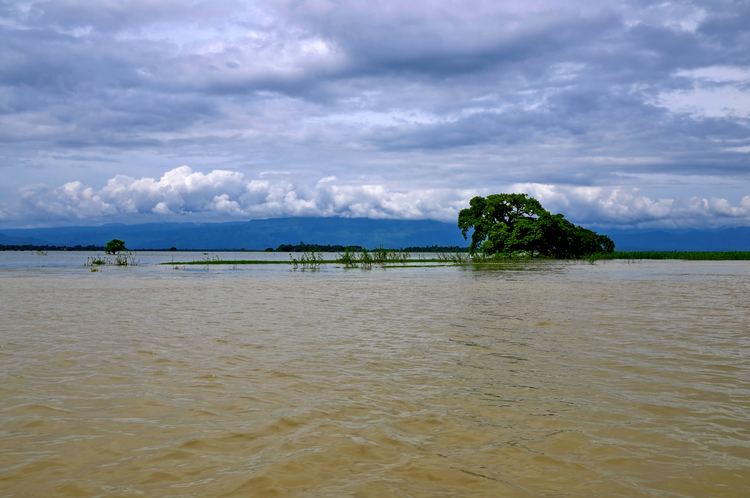
During July to November due to flood these areas go under deep water and look like seas with erosive water surface. During wind storm these waves reach up to 1.5 m in height. It remains under water for seven months of the year, turning haor settlements mostly built on earthen mounds into islands. During the dry season most of the water drains out, leaving small shallow lakes or may completely dry out by the end of dry season. This exposes rich alluvial soil, extensively cultivated for rice.
The fight against natural calamity of the locals people, mostly day laborers, relies on traditional and indigenous methods which with limited effect. Many villages have already been washed away, and many more are on the verge of extinction, forcing people to migrate to urban centers.
Environment
Compared with other major natural forms of landscape, a wetland is young, dynamic and physically unstable. Variously called jalah, doloni, pitoni, doba, hola or gadeng, it can change in a season or even in a single storm, as conditions range from virtually perennial aquatic lowlands to seasonally dry uplands. It changes with the vegetation, sedimentation, or geological subsidence. The key to vegetation development and community dynamics here is hydroperiod, affected by topography, flooding and flood type, precipitation, and water table fluctuations.
Due to continuous submergence, wetland habitat is characterized by anaerobic conditions which inhibits normal plant growth apart from a group of plants known as hydrophytes are adapted to withstand these conditions. The Haor Basin is the only region in Bangladesh where remnant patches of freshwater swamps and reed lands still exists. Once extensive forests of Hijal in the area used to provide an important source of firewood, but these forests are now almost completely destroyed. In recent times, various herbs and aquatic plants are being collected for use as fuel. On top of that, aquatic plants are also being collected for use as fertilizers. Only a few patches remain of the swamp forests that once dominated the area, featuring flood tolerant trees like Hijal (Barringtonia acutangula) and Koroch (Pongamia pinnata).
Joseph Dalton Hooker (1817-1911) did the original survey of local flora sometime in 1850, recorded in his Himalayan Journals (published by the Calcutta Trigonometrical Survey Office and The Minerva Library of Famous Books; Ward, Lock, Bowden & Co., 1891). The findings of his travels along the Surma and visiting the wetlands of Sylhet are reflected in his Flora of British India. Three habitat types in the Sylhet region were identified on the basis of botanical records of Kanjilal (U.N. Kanjilal, P.C. Kanjilal & A. Das; Flora of Assam; 1934):
The hijal or hual, korij or koroch, bhui dumur (Ficus heterophylla), nol (Arundo donax), khagra (Pharagmites karka), ban golap (Rosa involucratia) and barun (Crataeva nurvala) are the main plant species found in the swamp forests. All of them are flood-tolerant species and can survive in the submerged condition for extended periods of time. However, among these, hijal, tamal and koroj trees are of the greatest value to the people and the environment. Other plant species available in Bangladesh wetlands include madar (Erythrina variegata), gab (Diospyros peregrina), makna (Euryale ferox), singara (Trapa bispinosa), jaldumur (a kind of Ficus), chitki (Phyllanthus reticulatus), thankuni (Centella asiatica), kalmi (Ipomoea aquatica), helencha (Enhydra flactuans), hogla (Typha elephantina), duckweed, water hyacinth, lotus and water lily.
Eight plant communities have been identified in the haor area (number of species in parentheses): submerged plants (20), free floating plants (15), rooted floating plants (15), sedges and meadows (35), floodplain grassland, reed swamp (7), fresh water swamp forest (7), crop field vegetation (60), and homestead vegetation (63).
The extinct fauna of the area includes a few species that are included in the IUCN Red Data Book as highly endangered species, including one-horned rhinoceros (Rhinoceros unicornis), swamp deer (Cervus duvauceli), hispid hare (Caprolagus hispidus), swamp partridge (Francolinus gularis), Bengal florican (Eupodotis bengalensis) and marsh babbler (Pellorneum palustre).
Conservation
The international significance of the wetlands of the haor basin for their waterfowl populations was first drawn to the attention of the international conservation community at an International Regional Meeting on Conservation of Wildfowl Resources held in Saint Petersburg in September 1968. The Directory of Asian Wetlands (Scott, 1989), based on studies conducted by Abdul Wahab Akonda of the Forest Department, and by S.M.A. Rashid and Raguib Uddin Ahmed of the Wildlife Society of Bangladesh, identifies the wetlands of the haor basin, including ten key sites, of Sylhet and Mymensingh as a wetland ecosystem of outstanding international importance. Six of these key sites - Tanguar haor, Pashua beel and Gurmar haor, Hakaluki haor, Hail haor, Kawadighi haor, Balai haor - has been identified by Bangladesh Flood Action Plan as of outstanding national and international importance.
Three zones of international importance for conservation and sustainable utilization - the Meghna estuary, Tanguar haor and Hail-Hakaluki haors - have been declared as Ramsar sites under the Ramsar Convention for protection of wetlands, of which Bangladesh is a signatory. The Bangladesh government has also declared the Tnaguar haor an Ecologically Critical Area. The Haor basin has a number of government bodies working to preserve the environment, including the Forest Resources Management Project, Management of Aquatic Ecosystem through Community Husbandry (MACH), Haor and Floodplain Resource, Conservation and Management of Medicinal Plants and Coastal and Wetland Biodiversity Management at Cox’s Bazar and Hakaluki Haor(CWBMP).
Migratory birds
About 207 species of birds live or visit Bangladesh. Among the birds 30% are waterfowls, 26% waders, 20% bush and her bland birds and the rest are grassland, air hawking prey. Of these fresh water birds 129 species (62.3%) are resident and the other are migratory. The list of extinct wetland birds include spotbill pelican, pelican, scavenger vulture, Bengal florican, pinkheaded duck, greater adjutant and king vulture. There are several endangered species. Poachers pose the biggest danger to migratory birds. Although the Wildlife Preservation Act prohibits the hunting of migratory birds and wild animals, the law is not being implemented. Open sales of wild and migratory birds in the cities are all too flagrant. Guest birds trapped in Sylhet's haors are held captive in Srimangal town for sale in other cities. The poachers take advantage of the people’s lack of awareness of the importance of migratory birds.
While poaching, killing of birds, and their open sale in towns continues, it would be wrong to say that in Bangladesh there is no place where birds are safe from harm. In Kanglar haor in Sunamganj, guest birds are neither shot nor caught. Near the haor is the Birampur village, where people understand that as part of Mother Nature guest birds need to be cherished, not hunted. The local panchayet in this village banned the killing of birds in 2001. The initiative to save the birds was taken by Abdus Samad, an elderly villager, whose step has become a united move worthy of replication.
Human habitation
Prior to the 12th century there is alomost no information available on the human habitation here. The information up to the 17th century is sketchy. During the British period, this area was not stringently surveyed, and not a lot of information is available.
It is believed that the early settlers of the area were Hindus and other ethnic groups including Garo, Hajong, Khasi and Koch people coming down from the hills to the north. They were drawn to the area because of its productivity and favorable tenurial terms. With the expansion of Muslim power in the south and the west further Hindu migration continued in the 13th and 14th century. Following an Afghan defeat in Orissa in 1592, a large number of Afghans moved into the area. Expansion of Muslim population continued after the Muslim conquest of Sylhet in 1612, accelerating after the British conquest of Sylhet in 1765. By the 1770s all the cultivable land was brought under plough cultivation.
From the 1780s, population and area under cultivation declined till early 20th century, mostly due to successive natural calamities including floods and earthquakes. The haor basin became an important fishing zone during this time. Population growth picked up again in the 20th century, again due to the opportunity to cultivate land for a nominal rent.
Economy
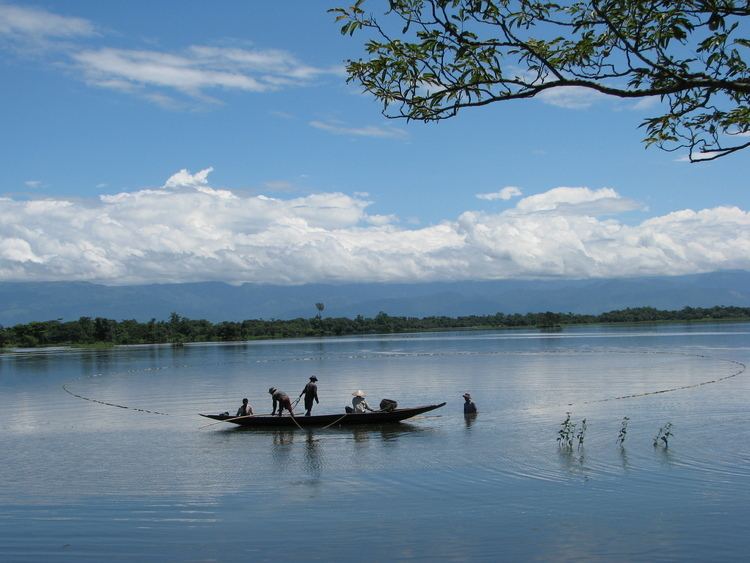
These haors and beels support major subsistence and commercial fisheries, while the seasonally flooded lake margins support major rice-growing activities, and the abundant aquatic vegetation provides rich grazing for domestic livestock and an alternative source of fuel and fertilizers for the local people. The main crop grown in the haor basin is boro rice or dry season rice. Early monsoon flash floods often cause extensive damage to the boro crop. Protection in the form of full flood dykes or submersible dykes is being provided in some of the developed areas.
Haors and baors, along with the rivers, canals and the floodplain, are a major source of fish production. But, due to siltation, and harvesting of excessive amounts of fish to meet the demand of growing populations production of fish from this source is gradually dwindling. In recent years, the wetlands have also been used for rearing domestic ducks.
Due to scarcity of cultivable land, government lands (Khas land) including the wetlands are increasing getting transferred to private ownership in Bangladesh. Thus most of the haors and beels have now been sold or leased to private individuals for cultivation during the dry season. This transfer is governed by the Haor Development Board Ordinance (Ordinance No. IX of 1977) are under the direct control of the Revenue Department in the Ministry of Land Administration and Land Reforms.
Tourism
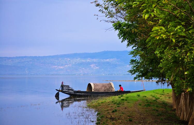
Haors are unique wetlands and have started attracting tourists, although in limited numbers. The best time to visit the haors is at the end of the monsoons, say around August–September, when they are full with water. Thereafter, the water in the haors starts receding but still provides an awe-inspiring sight. In winter, the haors and beels receive thousands of migratory birds. It is the ideal season for bird-watchers, but then the haors are reduced in size and lose much of their watery grandeur. As summer sets in the haors are no more there, but one can still see numerous beels.
Lonely Planet describes these areas as "some of the most fascinating rural areas of Bangladesh."