
Phone number 048-561-1121 Population 54,916 (Feb 2016) | Region Kantō Area 58.64 km² | |
 | ||
Weather 13°C, Wind W at 18 km/h, 45% Humidity University | ||
Hanyū (羽生市, Hanyū-shi) is a city located in Saitama Prefecture, in the central Kantō region of Japan. As of 1 February 2016, the city had an estimated population of 54,916 and a population density of 936 persons per km². Its total area was 58.64 square kilometres (22.64 sq mi).
Contents
- Map of Hanyu Saitama Prefecture Japan
- Geography
- Surrounding municipalities
- History
- Economy
- Education
- Railway
- Highways
- Local attractions
- Twin towns and sister cities
- References
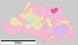
Map of Hanyu, Saitama Prefecture, Japan
Geography
Hanyū is located in the most northern part of Saitama Prefecture. Hanyū's northern border is the Tone River. Before the river was redirected to its current course to control flooding, it used to flow though the city. This river was used as a major shipping route for locally produced textiles and goods from further up river. Hanyū flourished as a stopping point on the long ride toward Tokyo. Today only an irrigation channel remains in the approximate location of the original river path.
Surrounding municipalities
History
The village of Hanyū was created within Kitasaitama District, Saitama with the establishment of the municipalities system on April 1, 1889. On September 1, 1954 Hanyū merged with the neighboring villages of Shingō, Sukage, Iwase, Kawamata, Iizumi, and Tegobayashi and was elevated to city status. The village of Chiyoda was annexed on April 1, 1959.
Economy
Traditional industries of Hanyū included textile dying and clothing production. The area was famous of its indigo production in the Edo period. Akebono Brake Industry is headquartered in Hanyū.
Education
Hanyū has 11 elementary schools, three middle schools and four high schools and one special education school.
Railway
Highways
Local attractions
Twin towns and sister cities
Yoshikawa is twinned with: