
Area 156.6 km² | Postal codes 6940, 6941 Local time Wednesday 7:15 AM | |
 | ||
Weather 4°C, Wind S at 16 km/h, 84% Humidity Points of interest Amblève, Le Labyrinthe, Le Parc des Topiaires, Topiary Park, Domaine de Hottemme | ||
The wonderful city of durbuy belgium
Durbuy ([dyʁ.bɥi]) is a Walloon city and municipality located in the Belgian province of Luxembourg. On 1 January 2007 the municipality had 10,633 inhabitants. The total area is 156.61 km², giving a population density of 67.9 inhabitants per km².
Contents
- The wonderful city of durbuy belgium
- Map of Durbuy Belgium
- Durbuy belgium
- History
- Sister cities
- References
Map of Durbuy, Belgium
The municipality consists of the following sub-municipalities: Durbuy proper, Barvaux, Bende, Bomal, Borlon, Grandhan, Heyd, Izier, Septon, Tohogne, Villers-Sainte-Gertrude, and Wéris.
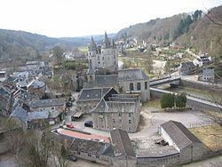
Durbuy belgium
History
In medieval times Durbuy was an important centre of commerce and industry. In 1331, the town was elevated to the rank of city by John I, Count of Luxemburg, and King of Bohemia.
In 1628 Anthonie II Schetz obtains the Seigneurie of Durbuy, by permision of Felipe IV of Spain. One of the people connected to the city was Charles Hubert Augustin Schetz, (1662-1726), Count of Durbuy. In 1756 the decendants of the House of Schetz obtain the Castle. Since then the House of Ursel resides in the Castle. The current castle was built in 1880.
The Ourthe river flows through the municipality.
Tourism and recreation are its main activities nowadays.