
District Saihaku Population 11,071 (1 Jun 2016) | Region ChūgokuSan'in - Tree Japanese yew Area 139.4 km² Local time Sunday 1:12 AM | |
 | ||
Weather 4°C, Wind SW at 6 km/h, 78% Humidity Points of interest Daisenmasumizukogen Ski Area, Uedashojishashin Museum, Hokicho Besshogawakeiryu Botanical | ||
Hōki (伯耆町, Hōki-chō) is a town in Saihaku District, Tottori Prefecture, Japan.
Contents
- Map of Hoki Saihaku District Tottori Prefecture Japan
- Neighboring municipalities
- Transportation
- Education
- References
Map of Hoki, Saihaku District, Tottori Prefecture, Japan
Hōki was formed on January 1, 2005 as the result of the merger of the town of Kishimoto, from Saihaku District, and the town of Mizokuchi, from Hino District.
As of April 1, 2011, the town has an estimated population of 11,745 and a density of 84.2 persons per km². The total area is 139.5 square kilometres (53.9 sq mi).
Hōki is the birthplace of the photographer Shōji Ueda (1913 – 2000). The town is home to the Shōji Ueda Museum of Photography, which is dedicated to the Ueda's works.
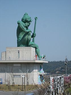
On the west side of the train tracks just after leaving Hōki-Mizoguchi station, a very large green statue of an Oni is visible on the hill overlooking the town and the Hino River. Before the Kishimoto-Mizokuchi town merger which created Hōki, the oni was Mizokuchi's town mascot and as such is featured on manhole covers, phone booths, post boxes and even the town's highway rest stop (where the building housing the restrooms is shaped like a giant oni head).
Neighboring municipalities
Hōki borders on five other municipalities, all in Tottori Prefecture.
Transportation
The Hakubi Line train line of JR West from Yonago to Okayama passes through Hōki with both local and express service. There are train stops at Hōki-Mizoguchi Station as well as Kishimoto Station.
The major road through Hōki is Route 181 which winds through the mountains from Yonago all the way to Okayama prefecture in the south. For the majority of its length it's a two lane highway and features steep switchbacks and often abrupt vertical drops to the valleys below. It roughly parallels the course of the Hino River until it reaches neighboring Kōfu, where Route 181 continues south, and Route 183 continues west to Nichinan and eventually Hiroshima, the capital of the Chūgoku region.
Education
There are two junior high schools in Hōki - Mizokuchi Junior High and Kishimoto Junior High. High school students typically take the train in to Yonago for class.