
Population 2,974 (1 Jun 2016) | Region ChūgokuSan'in - Tree Japanese Beech (Buna) Area 124.5 km² Local time Monday 8:16 AM | |
 | ||
Weather 6°C, Wind SE at 3 km/h, 49% Humidity Points of interest Okudaisen Ski Area, Mt. Kenashi, Seseragi Park, Giboshiyama, Kofucho Rekishiminzoku Museum | ||
Kōfu (江府町, Kōfu-chō) is a town located in the northeast of Hino District, Tottori Prefecture, Japan.
Contents
- Map of Kofu Hino District Tottori Prefecture Japan
- Etymology
- Geography
- Neighboring municipalities
- History
- Rail
- Highway
- References
Map of Kofu, Hino District, Tottori Prefecture, Japan
As of April 2012, the city has an estimated population of 3,390, with a population density of 27.2 persons per km². The total area of Kōfu is 124.66 square kilometres (48.13 sq mi).
Etymology
The name of the town of Kōfu was chosen in a referendum by its residents. In the Japanese language it is formed from two kanji characters. The first, 江, means "water", and the second, 府 means "center" or "core".
Geography
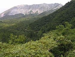
Kōfu is located in the Chūgoku Mountains. The northeast part of the town is on a plateau composed of pyroclastic soil. at the southern foot of Mount Daisen. The Hino River flows through the western part of the town. The southern part of the town, which borders Okayama Prefecture, is at a high altitude and is dominated by Mount Giboshi (1,110 metres (3,640 ft)), Mount Mihira (1,009.8 metres (3,313 ft)), and Mount Kenashi (1,218.4 metres (3,997 ft)).
Neighboring municipalities
History
The town of Kōfu was formed in 1953 by the merger of Ebi, Kanagawa, and Yonezawa.
Every August 17, there is a festival held in Kōfu called, "Juushichiya" (十七夜). Yatai (food stalls) of various kinds come and set up shop along the main road in Ebi, and people from all over come to participate in this festival. There is a sumo tournament in the early morning among the men who live in the town, and there is even a tournament for the school children as well. The kindergarten students play Japanese drums, taiko, in the evening along with other members of the town. There are fireworks as well in the evening. A 500-year-old traditional dance is also performed through the town and in the town's park; the dance is called "Kodaiji". The dance has been passed down for 500 years since the death of the lord who ruled over the town, and it is done in remembrance of him and to also wish for a plentiful harvest and successful year. The pinnacle of the festival occurs when townspeople light the hill facing the park on fire, spelling out the festival's name (十七夜) on the side of the hill.