
 | ||
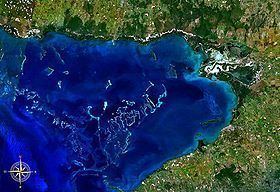
The Gulf of Guacanayabo (Spanish: Golfo de Guacanayabo) is a bay along the southern coast of Cuba, bordered by Granma and Las Tunas provinces. It is located at 20.5°N 77.5°W / 20.5; -77.5 (Gulf of Guacanayabo).
Contents
Map of Gulf of Guacanayabo, Cuba
Overview
The largest port on the bay is Manzanillo, and to the north-west, the gulf is bordered by the Jardines de la Reina archipellago. Cuba's longest river, the Cauto River empties in the Gulf of Guacanayabo.
It is also where, in 2005, Hurricane Dennis had its peak effect.
References
Gulf of Guacanayabo Wikipedia(Text) CC BY-SA