
Community Scarborough | ||
 | ||
Changed Municipality 1998 Toronto from Scarborough Restaurants Ace’s Place Bar Grill, Pizza Nova, Tim Hortons, Subway | ||
Guildwood, also known as Guildwood Village, is a residential neighbourhood in Scarborough, Toronto, Ontario, Canada. It is located along the Scarborough Bluffs, south of Kingston Road, from Grey Abbey Trail in the east (though in the past, Morningside Avenue was the eastern boundary) to the end of Sylvan Avenue in the west.
Contents
Map of Guildwood, Toronto, ON, Canada
History
After Metropolitan Toronto was formed in 1954, taxes on the Guild Inn property increased to the point that the owners Rosa and Spencer Clark decided to sell 450 acres (180 ha) of their property, which became the basis for the Guildwood Village subdivision. The Clarks remained involved with the development of the subdivision, in its design and layout to preserve as many trees in the area. Development started in 1957 with the famous "Avenue of Homes" display of upscale homes. The community introduced a number of new ideas in subdivision design, including winding roads and cul-de-sacs to reduce through traffic, and underground power and phone lines. " Rear-lot parks were modelled after English footpaths as walkways within the community."
The Clarks helped design the entrance gates to the subdivision. After most of Toronto's Stanley Barracks (New Fort York) was demolished in 1953, its gates were salvaged and re-erected at the entrance to Guildwood Village. These gates, now called the "Guildwood Gates" still provide a unique and grand entrance to the community at the corner of Kingston Road and Guildwood Parkway.43°44′58″N 79°12′20″W
The Guild
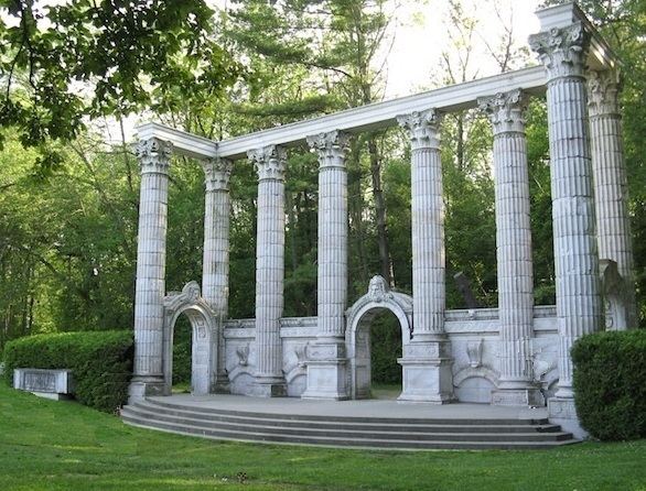
At the heart of the village is the Guild Inn, a former artists colony centre and hotel inside Guild Park and Gardens, which is operated by the City of Toronto. The Inn was closed in 2001. The Inn is slated to become part of a special events complex for weddings, meetings and parties. Guild Park is famous for its historical architectural fragments from the façades of demolished buildings in Downtown Toronto. Just west of the Guild Inn is Sir Wilfrid Laurier Collegiate Institute.
In popular culture
The Guild Park and Gardens is home to many movies such as The Skulls, and the neighbourhood is used by TV shows such as Odyssey 5. Drake's video "Headlines" was partly filmed at Guild Park by the amphitheatre. Saini Surinder's music video for a currently unreleased track as of February 2012 was shot at the Guildwood amphitheatre with Director Jared Pelletier.
Street names
Many of the streets in the Guildwood development were named by Rosa and Spencer Clark.
Source: Lidgold