
Formed January 9, 1975 Max rating | Dissipated January 12, 1975 Tornadoes confirmed 45 | |
 | ||
Similar December 2014 North American, Groundhog Day gale of 1976, Mid‑December 2007 North American, November 13–21 - 2014 Nort, November 2014 North American | ||
Weather history great storm of 1975 super bowl blizzard
The Great Storm of 1975 (also known as the Super Bowl Blizzard, Minnesota's Storm of the Century, or the Tornado Outbreak of January, 1975) was an intense storm system that impacted a large portion of the Central and Southeast United States from January 9 to January 12, 1975. The storm produced 45 tornadoes in the Southeast U.S. resulting in 12 fatalities, while later dropping over 2 feet (61 cm) of snow and killing 58 people in the Midwest. This storm remains one of the worst blizzards to ever strike parts of the Midwest, as well as one of the largest January tornado outbreaks on record in the United States.
Contents
- Weather history great storm of 1975 super bowl blizzard
- Meteorological synopsis
- Tornado summary event
- Blizzard
- Record events
- January 10
- January 11
- Low pressure measurements
- Tornadoes
- References
Meteorological synopsis
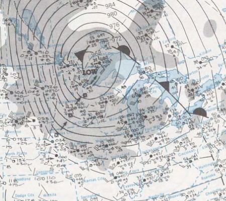
The storm originated over the Pacific Ocean and crashed into the Northwest Pacific coast with damaging gale-force winds on January 8, 1975. By January 9 it had cleared the Rocky Mountains and began to redevelop and strengthen. At the same time, Arctic air was being drawn southward from Canada into the Great Plains, and large amounts of warm tropical air from the Gulf of Mexico were being pulled northward into much of the eastern U.S. The storm was a classic Panhandle Hook which moved from Colorado into Oklahoma before turning northward towards the Upper Midwest. It produced record low barometric pressure readings in the Midwest, with the pressure falling to an estimated 28.38 in (961 mb) just north of the Minnesota border in Canada.
Tornado summary event
An unusual feature of this outbreak was that daytime heating, typically a key ingredient in the formation of tornadoes, had very little impact on their development. Rather, as the storm system pulled out into the central plains, strong thunderstorms and tornadoes quickly began to form despite the late hours. The first two tornadoes in the outbreak touched down after 10:00 p.m. CST on January 9 in Oklahoma and Louisiana. From there the progression of the twisters shifted eastward through the overnight and early morning hours, setting the stage for what would turn out to be a record setting day on January 10. Texas saw five tornadoes between 1:30 a.m.–3:30 a.m., one tornado touched down in Arkansas at 6:00 a.m., Louisiana saw seven tornadoes between 5:30 a.m.–8:00 a.m. (killing one person), Mississippi had five tornadoes between 8:15 a.m.–10:00 a.m. (killing nine), and Illinois and Indiana each experienced three lunch-hour tornadoes. The tornadic line of storms then shifted into Alabama (killing one) and Florida during the afternoon and evening hours.
Mississippi and Alabama were the two states hardest hit by this outbreak. Alabama saw the most twisters of any state with 13, but Mississippi saw the largest and deadliest tornado. An F4 tornado that tore through Pike, Lincoln, Lawrence, and Simpson Counties at 8:14 a.m. killed nine people and injured over 200; severely damaging 38 blocks in the town of McComb. The 39 tornadoes that touched down on January 10 marked the most active tornadic day in January in U.S. history at that time. The 52 tornadoes that touched down during January 1975 also set a U.S. record for the most tornadoes during that month. Both of these records were eventually broken in January 1999.
After a calm day on January 11, four more tornadoes touched down in Florida and Georgia on January 12, killing one person in Florida. By the time the outbreak was done it had produced 45 tornadoes, killed 12 people, injured 377 and caused $42 million in damages.
Blizzard
As the storm system began to move northeastward out of Oklahoma, the cool air behind pulled down behind the system interacted with the moisture being pulled northward to produce snow over a large part of the Midwest. The snow began falling on Friday, January 10 and continued for the next two days. Snowfall of a foot (30.5 cm) or more was common from Nebraska to Minnesota, with a high amount of 27 inches (69 cm) in Riverton, Minnesota. The heaviest snow fell to the west of the low pressure center, which tracked from northeast Iowa through central Minnesota up to Lake Superior. Sustained winds of 30 – 50 mph (48 – 80 km/h) with gusts from 70 – 90 mph (113 – 145 km/h) produced snowdrifts up to 20 feet (6 m) in some locations. Some roads were closed for up to 11 days.
Sioux Falls, South Dakota saw visibilities of below 1⁄4 mile (0.4 km) for 24 straight hours, and just east of Sioux Falls a 2,000-foot (610 m) broadcast tower collapsed under the storm's fury. In Willmar, Minnesota, 168 passengers were trapped in a stranded train for hours, unable to walk to shelter because of dangerously low wind chill values. In Omaha, Nebraska a foot (31 cm) of snow fell, Sioux Falls saw 7 inches (18 cm), Duluth, Minnesota saw 8 inches (20 cm), and International Falls, Minnesota saw 24 inches (61 cm).
Record low pressures were recorded in communities in Nebraska, Minnesota, Illinois, and Wisconsin, with a low of 28.55 in (966.8 mb) in Duluth, Minnesota. In all, approximately 58 people died from effects of the Blizzard and over 100,000 farm animals were lost. The combination of snowfall totals, wind velocities, and cold temperatures made this one of the most severe blizzards the Upper Midwest has experienced.
Record events
This storm system had, in part, a large effect on the weather in the entire eastern half of the country. A number of different weather records (at the time) were set during the four days of this storm, especially in daily high temperatures, wind gusts, low barometric pressure readings, and number of tornadoes.