
Area 921 km² Postal code 744301 | Total islands 1 Coastline 202 km (125.5 mi) Elevation 642 m Area code 03192 | |
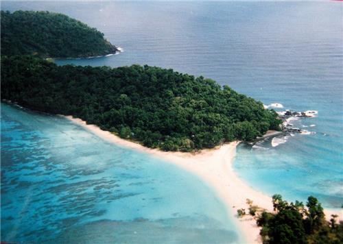 | ||
Great Nicobar (Hindi: बड़ा निकोबार, Nicobarese: टोकिओंग लोंग, Tokieong Long) is the southernmost and largest of the Nicobar Islands of India, north of Sumatra.
Contents
- Map of Great Nicobar Andaman and Nicobar Islands 744302
- History
- Geography
- Demography
- Topography
- Fauna
- Transportation
- Indira Point
- Indira Point lighthouse
- 2004 tsunami
- References
Map of Great Nicobar, Andaman and Nicobar Islands 744302
History
Great Nicobar island was severely affected by the 2004 Indian Ocean earthquake tsunami with many deaths, and was cut off from all outside contact for more than a day.
Geography
The island of Sumatra is located 180 km (110 mi) to the south of Great Nicobar. The island covers 921 km2 (356 sq mi) but is sparsely inhabited, with a population of 8067, largely being covered by rainforest and known for its diverse wildlife.
Demography
The island is home to the Great Nicobar Biosphere Reserve, Indira Point – the southernmost point of India and INS Baaz naval air station near Campbell Bay under the joint-services Andaman and Nicobar Command (ANC) of the Indian Armed Forces. It is the southernmost air station of the Indian Armed Forces.
The island is home to the Shompen people.
Topography
The island has several rivers, including the Alexandra, Amrit Kaur, Dogmar and Galathea. Virtually all rivers flow in a southern or southwesterly direction, which is indicative of the general slope of the terrain across the island. There are undulating hills throughout the island, with the main range running in a north-south orientation. Mount Thullier, which is part of this range, has the highest elevation of any point in the Nicobars, at 642 m above sea level.
Indira Point (6°45’10″N and 93°49’36″E) is the southernmost point of the Great Nicobar Island and India itself. Indira Point subsided 4.25 m in the 26 December 2004 tsunami and the lighthouse there was damaged. The lighthouse was subsequently made functional.
Fauna
The majority of the island is designated as the Great Nicobar Biosphere Reserve— home to many unique and endemic species of plants and animals including the Nicobar scrubfowl (Megapodius nicobariensis, a megapode bird), the edible-nest swiftlet (Aerodramus fuciphagus), the Nicobar long-tailed macaque (Macaca fascicularis umbrosa), saltwater crocodile (Crocodylus porosus), giant leatherback sea turtle (Dermochelys coriacea), Malayan box turtle, Nicobar tree shrew, reticulated python (Python reticulatus) and the giant robber crab (or coconut crab, Birgus latro).
Transportation
There is a 915m airstrip at Campbell Bay/Tenlaa on the East coast.
Indira Point
Indira Point is the name of the southernmost point of Republic of India. It is situated on Great Nicobar Island in the Nicobar Islands, which are located in the eastern Indian Ocean at 6°45’10″N and 93°49’36″E. This is not on the Indian mainland, but within the Union Territory of Andaman and Nicobar Islands. The name of the point was changed from Pygmalion Point on 18 October 1985 in commemoration of Indira Gandhi. It was formerly known by various names that include Pygmalion Point, Parsons Point, and for a brief period India Point.
It is located 540 km and more than a day’s sea voyage from Port Blair, the capital city and main port of the Andaman and Nicobar Islands. It is approximately 150 km by sea from Sumatra, Indonesia.
Indira Point lighthouse
Indira Point has a 35 m high cast iron (with red and white bands) lighthouse with 16 nautical miles range. The lighthouse has (RACON (Code ‘G’) ii DGPS station) with a 300 mm 4 panel revolving light inside a 2.5 m diameter lantern house (BBT). It is an important landmark on the international shipping lane Colombo-Singapore route via Malacca Strait that passes south of Indira Point. It also has a helipad.
2004 tsunami
The tsunami which resulted from the Indian Ocean earthquake of 2004 inundated much of the area. This partly damaged the lighthouse, which subsided 4.25 m. As a result of this subsidence, the coast retreated and the sea moved permanently inland. The lighthouse has since been repaired.
The base of the lighthouse was 5 m above sea level when constructed in 1972. After the tsunami, the sea rose and the base was less than a metre above the sea level, showing over 4 meters of sea floor subsidence. It has been observed that the sea is slowly retreating back to its original position and the subsidence has decreased as the ocean floor slowly bounces back partially, a similar drop and rise due to crustal decompression and re compression was observed in the 2011 Tōhoku earthquake and tsunami on Honshu. Indira point was mostly submerged.