
2011 census code 645188 | District Nicobar Time zone IST (UTC+5:30) Elevation 47 m | |
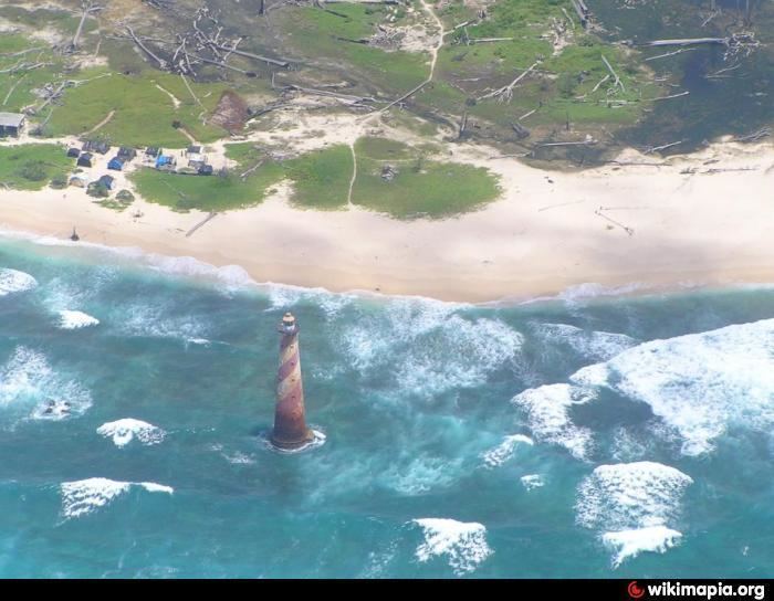 | ||
Indira point lighthouse submerged in greater nicobar island tsunami
Indira Point or Pygmalion Point is a village in the Nicobar district of Andaman and Nicobar Islands, India. It is located in the Great Nicobar tehsil. It is the location of the southernmost point of India's territory.
Contents
- Indira point lighthouse submerged in greater nicobar island tsunami
- Map of Indira Point Andaman and Nicobar Islands 744302
- Etymology
- History
- Administration
- Demographics
- References
Map of Indira Point, Andaman and Nicobar Islands 744302
Etymology
The village is named as Indira Point after former Prime Minister Indira Gandhi. The point was formerly known as Pygmalion Point and Parsons Point. It was renamed in honour of Indira Gandhi during mid-1980s. The announcement was made by the local Member of Parliament when Indira Gandhi visited the local light house on 19 February 1984. The official renaming ceremony happened on 10 October 1985.
History
The Indira Point lighthouse was commissioned into service on 30 April 1972.
Located 500 kilometres north of the epicenter of the 2004 Indian Ocean earthquake, the southernmost tip subsided 4.25 metres after the earthquake, and many of the inhabitants went missing in the tsunami that followed. Sixteen to twenty families living next to the lighthouse and four scientists studying leatherback sea turtles were lost.
Administration
The village comes under the administration of Laxmi Nagar panchayat.
Demographics
The village lost many of its residents in the 2004 tsunami. According to the 2011 census of India, Indira Point has only 4 households left. The effective literacy rate (i.e. the literacy rate of population excluding children aged 6 and below) is 85.19%.