
 | ||
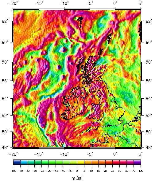
Variations in the strength of gravity occur from place to place according to the density distribution of the rocks beneath the surface. Such gravity anomalies have been mapped across the British Isles and adjacent areas and they reveal aspects of these islands’ geological structure.
Contents
Negative Anomalies
Negative gravity anomalies are associated with local deficiencies in mass due to volumes of rock which are less dense than the average. Typically these anomalies are associated with granite plutons and with sedimentary basins. Gravity anomaly maps of the British Isles are interpreted as indicating the presence of granite plutons in the following areas. The list is not exhaustive:
The Weardale Granite, a batholith some 60 km by 25 km in extent underlying the Alston Block of the northern Pennines, was first detected by gravity survey. Drilling of the Rookhope borehole subsequently confirmed the existence of this substantial body of granite. A combination of gravity anomaly data and boreholes has permitted geologists to work out the shape of this pluton. A further borehole was drilled at Raydale to investigate the origin of the gravity anomaly underlying the Askrigg Block. This proved the existence of the Wensleydale granite - a body of rock which is nowhere exposed at the surface.
Similarly, negative anomalies coincide with the following sedimentary basins (amongst others):
The negative anomaly associated with the Worcester Basin/Graben has sharp margins and is particularly pronounced. Work by researchers, Cook and Thirlaway and also by Brooks in the 1950s and '60s resulted in estimates of the thickness of the sedimentary rock sequence in the basin. Models for the structure of the basin are in part based on their interpretation of the gravity anomaly together with data from seismic surveys and a borehole at Kempsey.
Positive Anomalies
Positive gravity anomalies are associated with areas where Precambrian basement rocks are at or near the surface or where volumes of basalt or other similarly dense rocks have been put in place. Intense gravity highs coincide with a series of Palaeogene volcanic centres associated with the opening of the Atlantic Ocean and including those at:
The discovery of another volcanic centre, the wholly submarine Blackstones Bank Central Complex, was achieved through combining the results of magnetic, seismic and gravity surveys; its large positive gravity anomaly suggesting that it was a candidate site for further research.
In addition, intense gravity highs are associated with the Anton Dohrn and Hebrides Terrace seamounts. Gravity anomalies also accompany major lineaments, notably those associated with the Scottish Caledonides and including Great Glen Fault, Walls Boundary Fault, Highland Boundary Fault and Southern Uplands Fault.