
Address United Kingdom Phone +44 1969 652300 | Area 1,769 km² | |
 | ||
Similar Profiles | ||
The yorkshire dales when are you coming
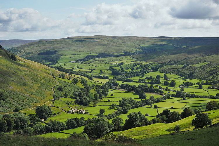
The Yorkshire Dales is an upland area of the Pennines in Northern England in the historic county of Yorkshire, most of it in the Yorkshire Dales National Park created in 1954.
Contents
- The yorkshire dales when are you coming
- Yorkshire dales gordale scar scramble malham cove
- Etymology
- Geography
- Geology
- Cave systems
- References
The Dales comprises river valleys and the hills, rising from the Vale of York westwards to the hilltops of the Pennine watershed. In Ribblesdale, Dentdale and Garsdale, the area extends westwards across the watershed, but most of the valleys drain eastwards to the Vale of York, into the Ouse and the Humber. The extensive limestone cave systems are a major area for caving in the UK.
Yorkshire dales gordale scar scramble malham cove
Etymology
The word dale, like dell, is derived from the Old English word dæl. It has cognates in the Nordic/Germanic words for valley (dal, tal), and occurs in valley names across Yorkshire and Northern England. Usage here may have been reinforced by Nordic languages during the time of the Danelaw.
Most of the dales are named after their river or stream (e.g., Arkengarthdale, formed by Arkle Beck). The best-known exception is Wensleydale, which is named after the small village and former market town of Wensley, rather than the River Ure, although an older name for the dale is Yoredale. River valleys all over Yorkshire are called "(name of river)+dale"—but only the more northern valleys (and only the upper, rural, reaches) are included in the term "The Dales".
Geography
The Yorkshire Dales spread to the north from the market and spa towns of Settle, Skipton, Ilkley and Harrogate in North Yorkshire, to the southern boundary in Wharfedale and Airedale. The lower reaches of these valleys are not usually included in the area, and Calderdale, much further south, is not part of the Dales even though it is a dale, is in Yorkshire, and its upper reaches are as scenic and rural as many further north. Most of the larger southern dales, Ribblesdale, Malhamdale and Airedale, Wharfedale and Nidderdale, run roughly parallel from north to south. The more northerly dales, Wensleydale and Swaledale run generally from west to east. There are many other smaller or lesser known dales such as Arkengarthdale, Bishopdale, Clapdale, Coverdale, Kingsdale, Littondale, Langstrothdale, Raydale, Waldendale and the Washburn Valley whose tributary streams and rivers feed into the larger valleys, and Barbondale, Dentdale, Deepdale and Garsdale which feed west to the River Lune.
The characteristic scenery of the Dales is green upland pastures separated by dry-stone walls and grazed by sheep and cattle. Many upland areas consist of heather moorland, used for grouse shooting from 12 August (the Glorious Twelfth).
Geology
The dales are 'U' and 'V' shaped valleys enlarged and shaped by glaciers, mainly in the most recent Devensian ice age. The underlying rock is mainly Carboniferous Limestone, which results in a large areas of karst topography, in places overlain with shale and sandstone and topped with Millstone Grit, although to the north and west of the Dent Fault the hills are formed from older Silurian and Ordovician rocks.
Cave systems
The underlying limestone in parts of the Dales has extensive cave systems, including the 87-kilometre (54-mile) long Three Counties System, making it a major area for caving in the UK. Some caves are open to the public for tours.
The systems include: