
Grape Vine Prairie 1844 Time zone CST (UTC-6) Local time Saturday 9:37 AM | Grape Vine 1854 Elevation 195 m | |
 | ||
Weather 20°C, Wind S at 11 km/h, 85% Humidity Points of interest Sea Life Grapevine, LEGOLAND Discovery Center D, Grapevine Vintage Railroad, Parr Park Sprayground, Dove Park | ||
Grapevine texas
Grapevine is a city located predominantly in Tarrant County and has areas that extend into Dallas and Denton counties. Highways SH 26, SH 121, SH 360, SH 114, Spur 97, and FM 2499 run into Grapevine. With its central location in the Metroplex, being approximately 22 to 24 miles from the downtowns of both Dallas and Fort Worth, Grapevine is a suburb of the Dallas/Fort Worth metroplex.
Contents
- Grapevine texas
- Map of Grapevine TX USA
- Destination grapevine grapevine texas
- History
- Geography
- Surrounding Cities
- Demographics
- Crime
- Economy
- Highways
- Airports
- Rail
- Bus
- Bicycle
- Running
- Local government
- School Districts
- Public High schools
- Private schools
- State government
- Federal government
- Media
- Notable people
- Places
- Sister cities
- References
Map of Grapevine, TX, USA
The city is part of the Dallas Fort Worth Statistical Area and a significant part of the city limits are mostly within the Dallas/Fort Worth International Airport, with neighboring cities such as Coppell, Euless, and Irving.
In recent years several wineries have opened in Grapevine, and the city has been very active in maintaining its historic downtown corridor. The city is adjacent to Grapevine Lake, a large reservoir impounded by the Army Corps of Engineers in 1952 and serves as both a source of water and recreational area. Part of Dallas/Fort Worth International Airport is located within Grapevine city limits, the largest portion of any municipality bordering the facility. In 2007 CNNMoney.com rated Grapevine as one of "America's Best Places to Live."
Destination grapevine grapevine texas
History
In October 1843, General Sam Houston and fellow Republic of Texas Commissioners camped at Tah-Wah-Karro Creek, also known as Grape Vine Springs, to meet with leaders of 10 Indian nations. This meeting culminated in the signing of a treaty of "peace, friendship, and commerce," which opened the area for homesteaders. The settlement that emerged was named Grape Vine due to its location on the appropriately-named Grape Vine Prairie near Grape Vine Springs, both names an homage to the wild grapes that grew in the area.
The first recorded white settlement in what would become the modern city occurred in the late 1840s and early 1850s. General Richard Montgomery Gano owned property near Grape Vine and helped organize the early settlement against Comanche raiding parties before leading his band of volunteers to battle in the American Civil War. Growth during the 19th century was slow but steady; by 1890 roughly 800 residents called Grapevine home, supported by such amenities as a newspaper, a public school, several cotton gins, a post office and railroad service. The settlement made continued gains early in the 20th century, and on January 12, 1914, the post office altered the town's name to one word, Grapevine. On Easter Sunday, April 1, 1934, Henry Methvin, an associate of Bonnie Parker and Clyde Barrow, killed two police officers, E.B. Wheeler and H.D. Murphy, during an altercation near Grapevine. A historical marker remains at the intersection of Dove Road and State Highway 114.
The population of Grapevine fell during the interwar period as the economy stagnated, though the city was officially incorporated in 1936. Cotton was the primary crop for Grapevine until the early 20th century when it was overtaken by cantaloupe farms which accounted for as many as 25,000 acres. For several decades until the early 1970s, the Rotary Club sign outside of town boasted Grapevine as "Cantaloupe Capital of the World". Population growth and economic gains resumed to some extent in the decades immediately after the Second World War, though the opening of Dallas-Fort Worth International Airport in 1974 spurred massive development in the area. Prior to the mid-20th century, Grapevine depended heavily upon agricultural production, but quickly transformed into a regional center of commerce because of its proximity to the airport's north entrance. The economic benefits of the airport's construction continue to encourage new levels of development in Grapevine to this day.
Geography
Grapevine is located at 32°56′6″N 97°5′9″W (32.935025, −97.085784).
According to the United States Census Bureau, the city has a total area of 35.9 square miles (93 km2), of which 32.3 sq mi (84 km2) is land and 3.6 sq mi (9.3 km2) (9.98%) is water.
Surrounding Cities
Here is the list of surrounding cities, they can also be seen from here.
Demographics
As of the census of 2010, there were 46,334 people, 18,223 households, and 12,332 families residing in the city. The population density was 1,451 people per square mile. There were 19,685 housing units. The racial makeup of the city was 81.1% White, 3.3% African American, 0.7% Native American, 4.5% Asian, 0.2% Pacific Islander, 8.0% from other races, and 2.2% from two or more races. Hispanic or Latino of any race were 18.0% of the population.
There were 18,223 households out of which 33.6% had children under the age of 18 living with them, 51.9% were married couples living together, 10.5% had a female householder with no husband present, and 33.3% were non-families. 27.1% of all households were made up of individuals and 14.4% had someone living alone who was 65 years of age or older. The average household size was 2.49 and the average family size was 3.06.
In the city, the population was spread out with 25.1% under the age of 18, 74.9% over the age of 18, 5.6% from 20 to 24, 13.3% from 25 to 34, 24.7% from 35 to 49, 20.9% from 50 to 64, and 7.9% who were 65 years of age or older. The median age was 37.5 years.
According to a 2010 estimate, the median income for a household was $76,040, and the median income for a family was $93,587. Males had a median income of $66,378 versus $47,995 for females. The per capita income for the city was $38,304. About 5.2% of families and 7.9% of the population were below the poverty line, including 11.3% of those under age 18 and 5.5% of those age 65 or over.
Crime
The Grapevine Police Department is the presiding jurisdiction, located on Dallas Road near downtown Grapevine. Since July 2010, there have been 33 car thefts, 23 assaults, 10 burglaries, and 2 robberies. According to the FBI, as of 2010, 28 registered sex offenders live in Grapevine.
On Christmas morning of 2011, AOL News (Huffington Post Crime) and the Associated Press reported that, after the receipt of an open-ended 911 call, all seven individuals (four women and three men, aged 15 to 60) in an apartment in a complex in suburban Grapevine (said to be most likely family members with related visitors) were found murdered, with the shooter, a man dressed as Santa Claus, believed to be one of the deceased extended family members. It was the worst incident of its kind ever in the Grapevine area and the first homicide since June 2010, according to police spokesman Sgt. Robert Eberling.
Economy
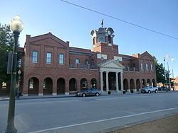
Grapevine's economy is largely centered around tourism of several varieties. Chiefly, travelers arriving and departing from Dallas/Fort Worth International Airport remain the majority of visits to the city, benefiting the numerous hotels. Among these facilities, the Gaylord Texan and Great Wolf Lodge stand in a separate class as massive entertainment complexes that offer hotel, convention, and performance space in addition to serving the recreational desires of both locals and tourists alike. Nearby Grapevine Mills Mall exists as a regional outlet shopping center with many amenities including an indoor ice rink and movie theater. Many of the top brands in fashion and other retail sectors maintain a space within the mall. Embassy Suites Grapevine and the DFW Lakes Hilton complex also lay adjacent to Grapevine Mills and Bass Pro Shops. In addition to these popular areas, Main Street in historic downtown Grapevine is a center of attraction for many people. City Hall, the Grapevine Convention and Visitor's Bureau, public library, and recreation center are located on Main Street in addition to a myriad of small business. These include antique stores, restaurants, bars, theaters, a park, and many specialty shops. The Grapevine Vintage Railroad follows a scenic route between Grapevine and the Fort Worth Stockyards, departing from a station located on South Main Street. The city is also the home of several wineries and tasting rooms to include Umbra Winery as well as the Texas Wine and Grape Growers Association.
According to the City's 2014 Comprehensive Annual Financial Report, the top employers in the city are:
GameStop, a national electronics retailer, is currently headquartered in Grapevine, one of the largest corporate employers in the city.
As of 2015 Kubota Corp. is establishing a new U.S. headquarters in Grapevine, moving about 350 employees from California and spending $51 million.
The facility at 1639 West 23rd Street is located on the property of DFW Airport and in Grapevine. Tenants include China Airlines, Lufthansa Cargo, and the U.S. Fish and Wildlife Service.
Historically, Grapevine was the headquarters of a collection of now-defunct air carriers. In 1978 Braniff Place, the final world headquarters for Braniff International Airways, was built in what is now Grapevine, on the grounds of Dallas/Fort Worth International Airport. Following Braniff's 1982 bankruptcy, the structure is now known as Verizon Place. In the 1990s Metro Airlines maintained its main offices in the city of Grapevine, as did Kitty Hawk Aircargo for a time.
Highways
Two grade-separated highways run through the city. State Highways 114 and 121 trisect Grapevine south and slightly west of downtown. 121 runs from the south and 114 from the northwest. The highways intersect near Mustang Drive and William D. Tate Avenue and continue together towards the airport before splitting again at the north entrance of Dallas/Fort Worth International Airport. Grapevine's highways as of 2010 underwent a significant overhaul to improve traffic flow through the area, with heavy construction expected to last until 2014.
Airports
Dallas/Fort Worth International Airport is the main provider of air service to Grapevine and the region at large, providing connections to places around the state, country, and abroad. DFW is the main hub for American Airlines, though other major carriers maintain a significant presence. Love Field in Dallas is relatively close to Grapevine.
Rail
The aforementioned Grapevine Vintage Railroad provides service to and from Fort Worth along the former Cotton Belt Railroad right-of-way. The service is not intended for commuting and acts more as a tourist attraction due to its slow speeds. However, the city's 50-year commitment to the Fort Worth Transportation Authority and approval of a half-cent sales tax increase is expected to pay dividends through the introduction of the TEX Rail service to northeast Tarrant County by 2018. New train stations downtown and north of the airport are included in the plans, as is a connection to DART Rail to provide mass transit service to the eastern half of the metroplex.
Currently, the closest connections to rail are the DFW airport, Terminal A, DART Rail station and the Hurst station for the Trinity Rail Express. Amtrak passenger service is available in both downtown Dallas and Fort Worth.
Bus
The Convention and Visitor's Bureau operates the Grapevine Visitor's Shuttle between points of interest within the city. Additional information including stops and pricing can be found here.
Bicycle
The majority of Grapevine's transportation infrastructure is centered around the automobile, though amenities for bicycles can be found. A bicycle route runs along the length of Dove Road beginning at the intersection of Dove and North Main Street, connecting Grapevine and Southlake. Additionally, the Cotton Belt trail runs parallel to State Highway 26, from the Colleyville city limits to downtown Grapevine. Other bicycle paths can be found at the various city parks, most notably the trail from Parr Park to Bear Creek Park. Off-road trails are also available. Northshore Mountain Bike trail begins at Rockledge Park on the north side of Grapevine Lake and continues into Flower Mound along the shore. Mileage is 22.5 miles broken up into two major loops: East Loops, 1 - 4, which are 12.5 miles and the West Loops, 5 - 7. Horseshoe Trail begins at Catfish Lane, continues to Dove Road, and loops back to the trail head, for a total of 5.4 miles.
Running
Grapevine received the Runner Friendly Community designation from the Road Runners Club of America. The goals of the Runner Friendly Community program are to shine a national spotlight on communities that standout as runner-friendly and provide incentives and ideas for communities to work towards becoming runner friendly communities. Grapevine has approximately 24-miles of hike and bike trails that link parks, schools, and businesses. The hike and bike trails have mileage markers that also have GPS coordinates for location identification in case of emergencies. The city also has an indoor 1/8 mile walking/jogging track and several outdoor tracks that belong to the local school district. The city has joint-use agreement with the school district for the use of school facilities.
The hike and bike trails in Grapevine include water fountains, community bathrooms or portable toilets, available parking, signs linking pedestrian networks, mile markers, walk lights at busy intersections, stop signs at residential intersections, and painted crosswalks. One trail in Grapevine links with four other communities, creating an additional 11-mile trail.
The City Parks & Recreation Board has worked with the running club, Lake Grapevine Runners and Walkers (LGRAW), over the last 15 years to make the city's trails runner friendly. The City of Grapevine invites LGRAW club to city sponsored health events to promote running, walking a healthy lifestyle
Local government
The structure of the management and coordination of city services is:
The city of Grapevine is a voluntary member of the North Central Texas Council of Governments association, the purpose of which is to coordinate individual and collective local governments and facilitate regional solutions, eliminate unnecessary duplication, and enable joint decisions.
School Districts
Most of Grapevine is served by the Grapevine-Colleyville Independent School District. A large portion of northwest Grapevine is served by Carroll ISD, while very small parts are served by Lewisville and Coppell ISDs.
Public High schools
Grapevine High School has been named both a National Blue Ribbon School and a New American High School. It was ranked by Newsweek as the 41st-best high school in the nation in 2007.
Colleyville Heritage High School also serves a large portion of Grapevine.
Private schools
The Faith Christian School is located in Grapevine.
State government
Grapevine is represented in the Texas Senate by Republican Jane Nelson District 12, and in the Texas House of Representatives by Republican Giovanni Capriglione, District 98.
Federal government
At the federal level, the two U.S. Senators from Texas are Republicans John Cornyn and Ted Cruz; Grapevine is part of Texas' US Congressional 24th District, which is currently represented by Republican Kenny Marchant.