Harman Patil (Editor)

Golden Chersonese

Updated on
Edit
Like
Comment
Share on FacebookTweet on TwitterShare on LinkedInShare on Reddit
Golden Chersonese THE MALAY HISTORY Golden Chersonese

Golden chersonese


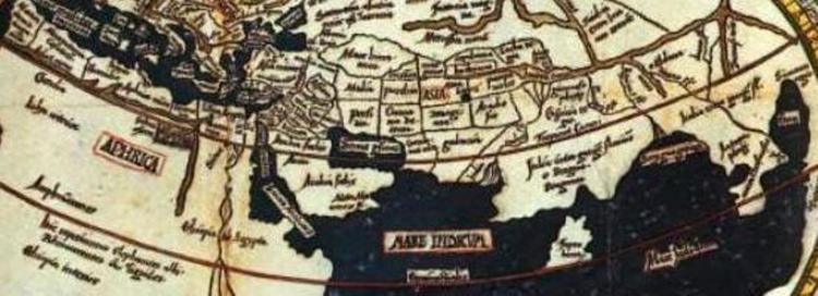
The Golden Chersonese or Golden Khersonese, meaning the Golden Peninsula (Ancient Greek: Χρυσῆ Χερσόνησος, Chrysḗ Chersónēsos; Latin: Chersonesus Aurea), was the name used for the Malay Peninsula by Greek and Roman geographers in classical antiquity, most famously in Claudius Ptolemy's 2nd-century Geography.

Contents

Golden Chersonese Golden Chersonese Miniatures

Artra golden chersonese series


Name

The earliest references to a fabulous land of gold that could be interpreted as places in South East Asia may be found in Indian literature. In Ramayana, there are mentions of Suvarnabhumi (Land of Gold) and Suvarnadvipa (the Golden island or Peninsula, where dvipa might refer to either a peninsula or an island). Greek knowledge of lands further to their east only improved after the conquests of Alexander the Great, but specific references to South East Asia did not appear until after the rise of the Roman Empire. Greek and Roman geographers Eratosthenes, Dionysius Periegetes, and Pomponius Mela had wrote about a Golden Isle (Khrysē, Chryse Insula), taken by some in modern times as meaning Sumatra while excluding the Malay Peninsula. Pliny in Natural History, however, referred to Chryse as both a promontory and an island.

Golden Chersonese assetscambridgeorg9781108014731cover97811080

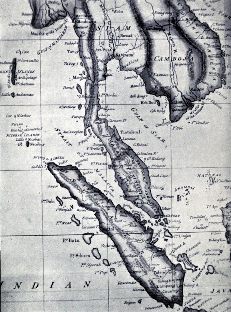
The Ptolemy's Geography, based on the work by Marinus of Tyre, contains the earliest reference to the Golden Chersonese. However, Geography includes information added by later geographers, and the first specific mention of the Golden Chersonese may be in the work of Marcian of Heraclea. Chersonese means peninsula in Greek, and although a few early scholars had attempted to link the Golden Chersonese with Lower Burma, the term is now generally accepted to mean the Malay Peninsula. The Malay Peninsula is thought to be a producer of gold in ancient times, and gold mines in Patani and Pahang were still mentioned in the 17th century by the Portuguese historian Godinho de Erédia. Although gold is now not a major product of modern-day Malaysia, it is still being mined, for example in Raub in Pahang.

Geographical locations

Golden Chersonese The Golden Chersonese by Isabella L Bird Reviews Discussion

The names of various geographical features and settlements of the Golden Chersonese are given in Ptolemy's Geography, including towns and rivers. Different identities however have suggested by different scholars for these names. Although coordinates are given for many of these places, they are not considered reliable for places so far away from the Mediterranean as they may not be based on astronomical observation, and cannot be reliably used for identification.

Rivers

Golden Chersonese GOLDEN CHERSONESE by Isabella Bird

The Ptolemy map shows three rivers which are joined together as their source a single river which does not actually exist. It has however been suggested that this might be indication of the existence of an ancient transpeninsular route that linked Perak and Pahang, a short cut between the east and west coast of the Malay Peninsula.

Golden Chersonese Index of sitesgutenbergorg26972697426974himages

  • Khrysoanas river, meaning "River of Gold", proposed to be various rivers on the west coast, from the Trang River (in southern Thailand) or Lungu River, to the Perak River or the Bernam River, or further south the Muar River.
  • Palandas river, proposed to be Johor River by a number of scholars.
  • Attabas river, which most authors agreed to be the Pahang River.
  • Settlements

  • Takola – a trading emporion, located at Trang in southern Thailand according to most authors. Takua Pa is another suggestion. Takola was known to the Indians in ancient times; a place named Takkola is mentioned in the 2nd or 3rd century Indian texts Maha Niddesa and Milinda Panha, and it is also considered to be the same as the Talaittakkōlam mentioned in the 1030 Tanjore inscription as one of the places conquered by Rajendra Chola in his invasion of Srivijaya. These Indian sources indicate the existence of Takola from the 3rd to 11th century.
  • Konkonagara – a place near the Khrysoanas, with many placing it in Perak (e.g. at Kuala Kangsar, in the Kinta District, along the Bernam river), but some placed it further north at the Muda River in Kedah. or Krabi opposite Phuket in Thailand. It is thought to be an Indian name, but it has also been proposed to be a hybrid of Malay and Sanskrit – kolong-kolong (or kekolong) and negara, meaning "the country of mines".
  • Sabara or Sabana – the second emporion, variously proposed to be in Selangor or near Klang, or just south of Malacca, or south Johor, as well as Singapore.
  • Tharra – at least 10 different sets of coordinates have been given in different texts for this site, it is therefore difficult to pinpoint.
  • Palanda – suggested to be Kota Tinggi by a few authors.
  • Kalonka – various sites ranging from Chumphon Province in southern Thailand to the Pahang River basin have been proposed.
  • Kole polis – thought to be located on the north east coast of the Malay Peninsula, and suggested to be in Kelantan, or somewhere between Kemaman River and Kuantan.
  • Perimula - placed on the north east coast of the Malay Peninsula, suggestions include Ligor, the deltas of Kelantan or Trengganu River, and Redang Island.
  • Other features

  • Cape Maleoukolon – perhaps the south east corner of the Malay Peninsula.
  • The Perimulikos gulf – possibly the Gulf of Siam.
  • References

    Golden Chersonese Wikipedia