
Country Australia Status Operational Catchment area 1,891 km² Construction began 1919 Spillway 2 | Opening date 1927 Height 37 m Owner Southern Rural Water | |
 | ||
Similar Bonang River, Cumberland River, Caledonia River, Little River, Wongungarra River | ||
Sandy point and glenmaggie dam drone views gippsland
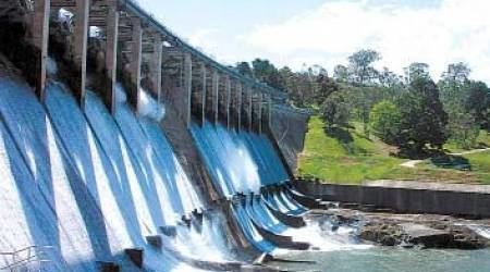
The Glenmaggie Dam is a concrete rock foundation gravity dam with two uncontrolled spillways across the Macalister River, located near Sale, Central Gippsland, in the Australian state of Victoria. The dam's purpose includes irrigation, the generation of hydro-electric power, water supply and conservation. The impounded reservoir is called Lake Glenmaggie.
Contents
Location and featuresEdit
Construction of the Glenmaggie Dam commenced in 1919, was completed in 1927 and constructed by the State Rivers and Water Supply Commission of Victoria. When full following its construction, the dam held 132,000 megalitres (4,700×10^6 cu ft) and provided irrigation to approximately 360 square kilometres (140 sq mi) of farming land in the Central Gippsland region; via a gravity irrigation systems to properties in the Macalister Irrigation District, near the towns of Maffra, Heyfield, Stratford and Sale. The Macalister Irrigation District covers about 53,000 hectares (130,000 acres) around the Macalister and Thomson rivers, extending from Lake Glenmaggie to Sale. It comprises two areas: the Maffra-Sale Irrigation Area to the north of the Thomson River and the Central Gippsland Area (including the Nambrok-Denison Soldier Settlement district) to the south.
The Glenmaggie Dam wall, which creates the Glenmaggie Lake, is a mass concrete overfall dam with irrigation outlets on both sides of the river serving irrigation channels. The central portion is an overfall spillway. The dam wall was raised in 1958 by the addition of gates; stabilised using ground anchors in 1989; and upgraded in 2003 to enable it to withstand overtopping.
In 1994, a hydro-electric power station with two Francis turbine-generators was commissioned, with a capacity of 4 megawatts (5,400 hp) and generating 9 gigawatt-hours (32 TJ) per annum.
FloodingEdit
In June 2007, the Macalister catchment experienced record flooding. Inflows into Lake Glenmaggie peaked in excess of 250,000 megalitres (5.5×10¹⁰ imp gal; 6.6×10¹⁰ US gal) per day and releases peaked at 147,000 megalitres (3.2×10¹⁰ imp gal; 3.9×10¹⁰ US gal) per day. A second flood occurred in November 2007 with inflows into Lake Glenmaggie peaking at 70,000 megalitres (1.5×10¹⁰ imp gal; 1.8×10¹⁰ US gal) per day and releases peaking at 59,000 megalitres (1.3×10¹⁰ imp gal; 1.6×10¹⁰ US gal) per day. Repairs totaling around A$4 million were completed after the June and November 2007 floods.