
- elevation 767 m (2,516 ft) | - elevation 503 m (1,650 ft) Country Australia | |
 | ||
- location below Mountain Little Bill - location south of the Black-Allan Line Similar Little River, Wongungarra River, Buchan River, Cumberland River, Caledonia River | ||
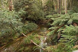
The Bonang River is a perennial river of the Snowy River catchment, located in the Alpine region of the Australian state of Victoria.
Contents
Map of Bonang River, Victoria, Australia
Course and features
Formed by the confluence of the northern and southern branches of the river, the Bonang River rises below Mountain Little Bill in a remote alpine wilderness area within the Snowy River National Park, near The Gap Scenic Reserve. The river flows generally north leaving the national park, then northwest, and then west, joined by six minor tributaries, before reaching its confluence with the Deddick River in the Victorian State Forestry country, below Mount Rosendale in the Shire of East Gippsland, south of the Black-Allan Line that forms part of the border between Victoria and New South Wales. The river descends 264 metres (866 ft) over its 30-kilometre (19 mi) course.
In its upper reaches, the river is traversed by Bonang Road north of the road's junction with McKillops Road.
Aboriginal history
The traditional custodians of the land surrounding the Bonang River are the Australian Aboriginal Bidawal and Nindi-Ngudjam Ngarigu Monero peoples.