
Area 2,315 km² Phone +1 509-664-9200 | Governing body U.S. Forest Service Established 1964 | |
 | ||
Management United States Forest Service | ||
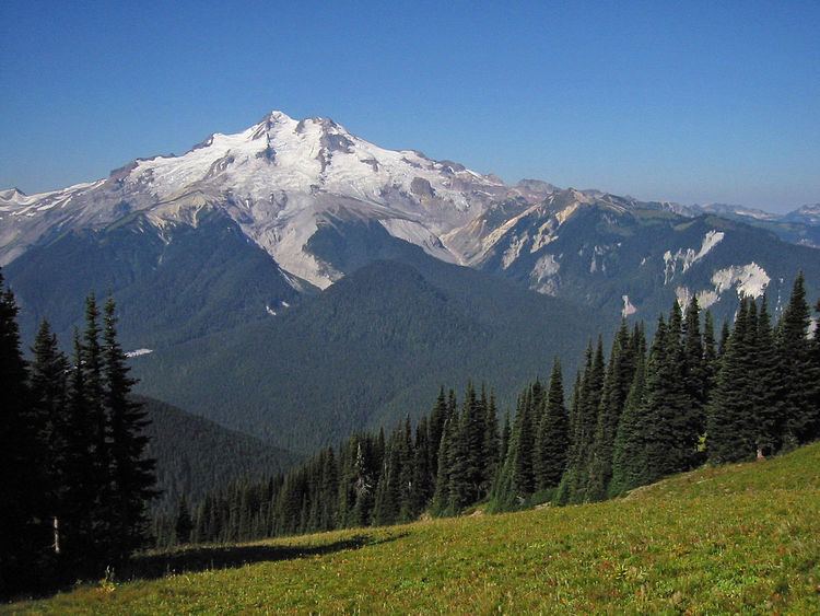
Glacier Peak Wilderness is a 566,057-acre (229,075 ha), 35-mile-long (56 km), 20-mile-wide (32 km) wilderness area located within portions of Chelan, Snohomish, and Skagit counties in the North Cascades of Washington. The area lies within parts of Wenatchee National Forest and Mount Baker National Forest and is characterized by heavily forested stream courses, steep-sided valleys, and dramatic glacier-crowned peaks. The dominant geologic feature of the area is 10,541-foot (3,213 m) Glacier Peak. It is the most remote major volcanic peak in the Cascade Range and has more active glaciers than any other place in the lower forty-eight states. Glacier Peak is a volcanic cone of basalt, pumice, and ash which erupted during periods of heavy glaciation.
Contents
Glacier peak wilderness
History
Glacier Peak Wilderness was created by the U.S. Forest Service in 1960 through the efforts of the North Cascades Conservation Council, four years before the 1964 wilderness legislation of the Congress.
Ecology
Forest vegetation comprises several species of fir, Douglas fir, hemlock, red cedar as well as stands of mixed pine and Douglas fir on its eastern slopes. Various species of wildlife inhabit the area and include deer, elk, black bear, mountain goat, cougar, marten, and lynx. Smaller animals, such as field mice are common. The last confirmed grizzly bear sighting in the United States portion of the North Cascade ecosystem occurred in this wilderness. The high mountain lakes often give good catches of fish during their ice-free months. The primary fishery is cutthroat trout, however, other species do exist.
Access
No roads approach Glacier Peak, and many miles of hiking through extremely rough terrain to reach its base. Normally, hikers can reach the volcano from the west via the White Chuck River Valley, or the Suiattle River Valley; from the east, it may be approached from the western tip of Lake Chelan or the White River or Chiwawa River valleys.
Trail conditions
Most years the wilderness is still buried under 10 to 20 feet (300 to 600 cm) of snow in May. Usually most trails and passes are snow free by mid-August, but this varies from year to year. Snow and cold rain can occur in mid-summer.
Flood damage
On October 20, 2003, there was a record-setting flood event when over 10 inches (250 mm) of rain fell on the wilderness. The warm rain melted snow and ice driving massive amounts of water, trees and debris into the rivers. Downstream, roads, bridges, campgrounds and trails were damaged and destroyed. The destruction was particularly devastating to the Pacific Crest Trail (PCT). Eight trail bridges and one stream ford on a 30-mile (48 km) section of the trail below Glacier Peak were destroyed. Little or no evidence remains that some of these bridges ever existed. The two most notable losses were bridges over the Upper White Chuck River and the Suiattle River. Both crossings are dangerous fords under the best of conditions. Additionally, five major trails that provided access to the PCT in the area sustained varying degrees of damage from fairly light (North Fork Skykomish Trail) to severe (White Chuck Trail). Kennedy Hot Springs was buried in a mudslide and completely destroyed. Construction on the Suiattle River road began in 2013 and was scheduled to be completed by October 2014.