
Surface area 2,563 ha (6,330 acres) Surface elevation 205 m | Type fresh water lake Max. length 1.83 km (1.14 mi) Average depth 4 m (13 ft) Area 25.63 km² | |
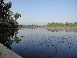 | ||
Ghodaghodi Tal is a Ramsar site in western Nepal. Established in August 2003 it covers an area of 2,563 ha (6,330 acres) in Kailali District at an altitude of 205 m (673 ft) on the lower slopes of the Siwalik Hills. This Ramsar site consists of a system of around 13 large and shallow oxbow lakes and ponds with associated marshes and meadows. It is surrounded by tropical deciduous forest and some streams along the periphery, which are separated by hillocks.
Contents
Map of Ghodaghodi Lake, 10900, Nepal
Flora
The lake has record of 388 vascular plants: five ptredophytes, 253 dicots, and 130 monocots.
Fauna
The forest and wetlands serve as a wildlife corridor between the Terai lowland and the Siwalik Hills. They support critically endangered and vulnerable species including Bengal tiger, smooth-coated otter, Eurasian otter, swamp deer, lesser adjutant stork, marsh crocodile, red-crowned roofed turtle and three-striped roofed turtle.