
Length 155.3 km | ||
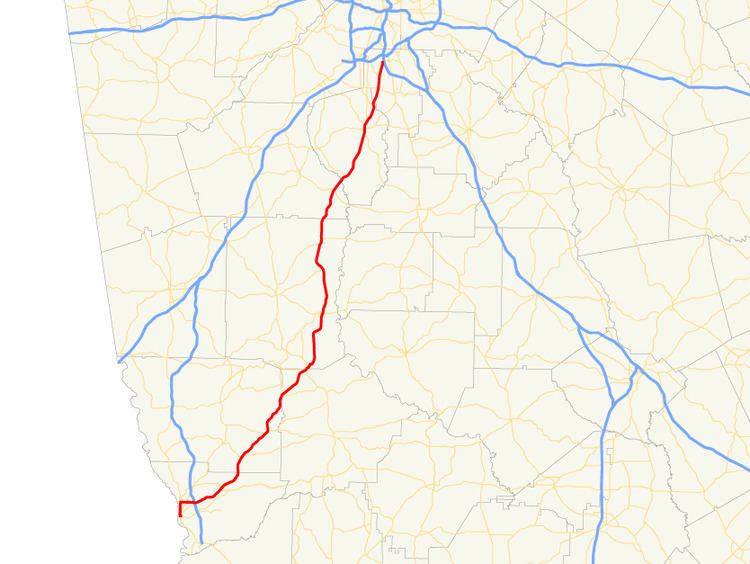 | ||
State Route 85 (SR 85) is a 96.5-mile-long (155.3 km) state highway in the west-central part of the U.S. state of Georgia. Its routing passes within portions of Muscogee, Harris, Talbot, Meriwether, Coweta, Fayette, and Clayton counties. It connects the Columbus and Forest Park areas, via Manchester, Woodbury, and Fayetteville.
Contents
Map of GA-85, Georgia, USA
Route description
SR 85 begins at an intersection with US 27/SR 1 (Veterans Parkway) in downtown Columbus, within Muscogee County. It heads west on 14th Street, before turning north on 2nd Avenue. It continues to the north, until it meets the southern terminus of SR 22 Connector, which takes on the "2nd Avenue" name. At this intersection, SR 85 heads east on Manchester Expressway and meets SR 219 (River Road) before it has a second intersection with US 27/SR 1 (Veterans Parkway). At this intersection, US 27 Alternate begins, running concurrent with SR 85. The two routes continue to the east, to an interchange with Interstate 185 (I-185), then curve to the northeast on the south side of Peachtree Mall, which is located just south of the Columbus Airport. Just past the mall, the highways become a limited-access highway. They have an interchange with Warm Springs Road, which leads to Cooper Creek Park. They head to an interchange with Miller Road, which leads to the neighborhood of Crystal Valley. To the northeast is US 80/SR 22. Then, they meet County Line Road, which leads to Midland. This road is actually about 3,000 feet (910 m) south of the Muscogee–Harris county line. In Harris County, the concurrency skirts past the Woodland Hills Golf Course. Just before entering Ellerslie, the limited-access highway ends. A little while later, SR 315 joins the concurrency, and leaves it in town. US 27 Alternate/SR 85 head to Waverly Hall, where they intersect SR 208. On the Harris–Talbot county line, the two routes meet SR 85 Alternate/SR 116. At this intersection, US 27 Alternate north/SR 85 Alternate north/SR 116 west take the left fork, on Warm Springs Road, while SR 85 north/SR 116 east take the right one. Less than 0.5 miles (0.80 km) into Talbot County, SR 116 splits off to the east, while SR 85 continues to the northeast. Just before entering Manchester is SR 41, which begins a short concurrency. Almost immediately, the two routes cross into Meriwether County and enter Manchester. They intersect the eastern terminus of SR 190 (Pine Mountain Highway) just after the city limits. At 2nd Street, SR 41 departs to the northwest, while SR 85 heads into downtown Manchester. At Foster Street, SR 85 turns to the east, while SR 85 Spur continues straight ahead, on Truitt Street. In Woodbury, it meets SR 18/SR 74/SR 109 (Woodbury Highway). At this intersection, SR 74 turns to the north, concurrent with SR 85. They reach the northern terminus of SR 85 Alternate (Whitehouse Parkway). Farther to the north-northwest, in Gay, is the eastern terminus of SR 109 Spur (Greenville Street). In the unincorporated community of Alps, they intersect SR 362, which briefly joins the concurrency. Less than 3 miles (4.8 km) later, they reach the Meriwether–Coweta county line. The concurrent highways pass through Haralson and enter the southeast part of Senoia. There, they intersect with SR 16 (Wells Street). Less than 2 miles (3.2 km) later, they cross over Line Creek, into Fayette County. They enter Starrs Mill, where SR 74 (Joel Cowan Parkway) departs to the northwest, while SR 85 continues to the northeast. In Fayetteville, it intersects SR 92, which forms a concurrency through the city. Then, they intersect SR 54. After that, SR 92 departs to the northwest. Next, is the southern terminus of SR 314. Farther on, in Kenwood, is the southern terminus of SR 279. After that, SR 85 crosses over Camp Creek, into Clayton County. On the southwestern edge of Riverdale, it intersects SR 138. Approximately 2,000 feet (610 m) later is the southern terminus of SR 139 (Church Street). Farther to the north-northeast is the western terminus of SR 331 (Forest Parkway), which the northbound lanes of SR 85 have to take to access I-75. SR 85's northbound lanes continue for another 3,000 feet (910 m), and then they end at a U-turn to go back to the south. However, the southbound lanes actually start at I-75, approximately 1,500 feet (460 m) farther to the north-northeast.
There are two sections of SR 85 that are part of the National Highway System, a system of roadways important to the nation's economy, defense, and mobility:
State Route 85 Alternate
State Route 85 Alternate (SR 85 Alternate) is a 18.7-mile-long (30.1 km) alternate route that connects the Shiloh and Woodbury areas, via Warm Springs. From its southern terminus to Warm Springs, it is concurrent with U.S. Route 27 Alternate.
SR 85 Alternate is not part of the National Highway System, a system of roadways important to the nation's economy, defense, and mobility.
State Route 85 Spur
State Route 85 Spur (SR 85 Spur) is a spur route that exists completely within Manchester. It connects SR 41 (North 5th Avenue) with the SR 85 mainline. It is used to bypass downtown Manchester.
SR 85 Spur is not part of the National Highway System, a system of roadways important to the nation's economy, defense, and mobility.
The entire route is in Manchester, Meriwether County.