
Existed: 1946 – present Length 40.2 km | Constructed 1946 | |
 | ||
East end: US 221 / US 319 / SR 78 / SR 171 in Bartow Counties | ||
State Route 242 (SR 242) is a west-east state highway located in the central part of the U.S. state of Georgia. It runs for approximately 25 miles (40 km) through portions of Washington and Jefferson counties.
Contents
Map of GA-242, Georgia, USA
Route description
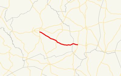
SR 242 begins at an intersection with SR 24 (Fall Line Freeway) in Sandersville in Washington County. The route makes an quick turn towards downtown Sandersville as SR 242 Spur continues straight. The route turns south onto SR 15 in the center of the city. After a 0.6-mile-long (0.97 km) concurrency with SR 15, SR 242 turns east at Riddleville Road. This intersection was its original terminus until the Fall Line Freeway was completed. The route heads out of the city in a southeast direction. Just before leaving Sandersville, it crosses a Sandersville Railroad line. Farther to the southeast, it crosses a Central of Georgia Railway line. The road passes Jackson Cemetery before reaching Riddleville. In Riddleville, it intersects SR 231 (Harrison-Riddleville Road to the south and Riddleville-Davisboro Road to the north). After leaving town, SR 242 continues to the southeast, and gradually curves to the east and crosses into Jefferson County. It continues to the east to meet its eastern terminus, an intersection U.S. Route 221 (US 221)/US 319/SR 78/SR 171 in Bartow.
The only portion of SR 242 part of the National Highway System is along its concurrency with SR 15 in Sandersville.
History
SR 242 was established in 1946 along the same alignment as it runs today. In 1950, the section from the western terminus to a point just over halfway to Ridleville was paved. In 1953, the entire length of the highway was paved.
SR 242 Spur
State Route 242 Spur (Spur 242) is a two-and-a-half-mile-long (4.0 km) special route of SR 242 west of Sandersville. It begins at an intersection with Kaolin Road and South Saffold Road near Kaolin Field, an airport serving the city, and an industrial factory. The road heads northwest through a forested area intersecting no paved roads until it curves to the north to end at SR 242, only one-tenth mile (0.16 km) from the latter's terminus at SR 24. The road is signed north-south and has a speed limit of 45 miles per hour (70 km/h).