
Area 1,772 km² Population 20,676 (2013) | Congressional district 10th Website washingtoncountyga.gov Founded 1784 | |
 | ||
University Oconee Fall Line Technical College Points of interest Hamburg State Park, Old Jail Museum, Georgia's Oldest Jail | ||
Washington County is a county located in the U.S. state of Georgia. As of the 2010 census, the population was 21,187. The county seat is Sandersville. The county was established on February 25, 1784. It was named for Revolutionary War general (and later President of the United States) George Washington.
Contents
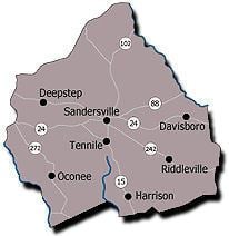
- Map of Washington County GA USA
- Geography
- Adjacent counties
- 2000 census
- 2010 census
- Education
- In popular culture
- References
Map of Washington County, GA, USA
Geography
According to the U.S. Census Bureau, the county has a total area of 684 square miles (1,770 km2), of which 678 square miles (1,760 km2) is land and 5.9 square miles (15 km2) (0.9%) is water.
The western portion of Washington County, west of a north-to-south line running through Sandersville, is located in the Lower Oconee River sub-basin of the Altamaha River basin. The northeastern portion of the county, north of Riddleville, is located in the Upper Ogeechee River sub-basin of the Ogeechee River basin, while the southeastern portion, centered on Harrison, is located in the Ohoopee River sub-basin of the Altamaha River basin.
Adjacent counties
2000 census
As of the census of 2000, there were 21,176 people, 7,435 households, and 5,382 families residing in the county. The population density was 31 people per square mile (12/km²). There were 8,327 housing units at an average density of 12 per square mile (5/km²). The racial makeup of the county was 45.73% White, 53.20% Black or African American, 0.17% Native American, 0.26% Asian, 0.01% Pacific Islander, 0.20% from other races, and 0.43% from two or more races. 0.63% of the population were Hispanic or Latino of any race.
There were 7,435 households out of which 34.60% had children under the age of 18 living with them, 46.70% were married couples living together, 21.50% had a female householder with no husband present, and 27.60% were non-families. 24.80% of all households were made up of individuals and 10.60% had someone living alone who was 65 years of age or older. The average household size was 2.65 and the average family size was 3.17.
In the county, the population was spread out with 26.90% under the age of 18, 8.80% from 18 to 24, 30.30% from 25 to 44, 21.40% from 45 to 64, and 12.60% who were 65 years of age or older. The median age was 36 years. For every 100 females there were 81.50 males. For every 100 females age 18 and over, there were 75.20 males. The median income for a household in the county was $29,910, and the median income for a family was $36,325. Males had a median income of $33,263 versus $21,388 for females. The per capita income for the county was $15,565. About 18.70% of families and 22.90% of the population were below the poverty line, including 30.00% of those under age 18 and 23.20% of those age 65 or over.
2010 census
As of the 2010 United States Census, there were 21,187 people, 7,547 households, and 5,269 families residing in the county. The population density was 31.2 inhabitants per square mile (12.0/km2). There were 9,047 housing units at an average density of 13.3 per square mile (5.1/km2). The racial makeup of the county was 52.7% black or African American, 45.0% white, 0.5% Asian, 0.1% American Indian, 0.7% from other races, and 1.0% from two or more races. Those of Hispanic or Latino origin made up 1.9% of the population. In terms of ancestry, 10.4% were American.
Of the 7,547 households, 35.4% had children under the age of 18 living with them, 42.8% were married couples living together, 22.4% had a female householder with no husband present, 30.2% were non-families, and 27.2% of all households were made up of individuals. The average household size was 2.56 and the average family size was 3.10. The median age was 38.9 years.
The median income for a household in the county was $31,382 and the median income for a family was $41,055. Males had a median income of $35,699 versus $24,860 for females. The per capita income for the county was $15,033. About 19.0% of families and 27.6% of the population were below the poverty line, including 35.6% of those under age 18 and 18.2% of those age 65 or over.
Education
The county is served by the Washington County School District, which includes:
The county is also the location of one privately run school:
In popular culture
The 1933 short story The People's Choice by Erskine Caldwell is set in Washington County, where the story's protagonist is a popular local politician elected again and again as the county's tax assesor.
The biography of one of the main characters (Grant Alexadner) in the 2011 console game "X-Men: Destiny" states that they were born in Sandersville, Georgia.