
Country United States County Washington Incorporated 1812 Zip code 31082 Local time Tuesday 5:48 AM | Founded 1796 Elevation 446 ft (136 m) Population 5,837 (2013) | |
 | ||
Weather 15°C, Wind SW at 8 km/h, 71% Humidity Colleges and Universities Oconee Fall Line Technical College, Sandersville Technical College | ||
Civil war battle in sandersville georgia
The city of Sandersville is the county seat of Washington County, Georgia, United States. The population was 5,912 at the 2010 census. It is also a part of the Central Savannah River Area.
Contents
- Civil war battle in sandersville georgia
- Map of Sandersville GA USA
- Geography
- Demographics
- History
- Economy
- Washington County School District
- Private education
- Higher education
- Newspaper
- References
Map of Sandersville, GA, USA
Geography
According to the United States Census Bureau, the city has a total area of 10.45 square kilometres (4.03 sq mi), of which, 9.1 square miles (24 km2) of it is land and 0.1 square miles (0.26 km2) of it (0.87%) is water.
Demographics
As of the census of 2011, there were 6,097 people, 2,315 households, and 1,568 families residing in the city. The population density was 672.1 people per square mile (259.5/km²). There were 2,566 housing units at an average density of 283.2 per square mile (109.4/km²). The racial makeup of the city was 59.03% African American, 39.76% White, 0.11% Native American, 0.60% Asian, 0.05% Pacific Islander, 0.03% from other races, and 0.41% from two or more races. Hispanic or Latino of any race were 0.24% of the population.
There were 2,362 households out of which 31.8% had children under the age of 18 living with them, 37.2% were married couples living together, 25.8% had a female householder with no husband present, and 32.6% were non-families. 30.0% of all households were made up of individuals and 13.3% had someone living alone who was 65 years of age or older. The average household size was 2.52 and the average family size was 3.13.
In the city, the population was spread out with 28.0% under the age of 18, 7.8% from 18 to 24, 26.5% from 25 to 44, 21.8% from 45 to 64, and 15.9% who were 65 years of age or older. The median age was 37 years. For every 100 females there were 79.6 males. For every 100 females age 18 and over, there were 72.4 males.
The median income for a household in the city was $27,201, and the median income for a family was $32,462. Males had a median income of $36,089 versus $21,765 for females. The per capita income for the city was $18,226. About 24.3% of families and 27.5% of the population were below the poverty line, including 36.2% of those under age 18 and 24.1% of those age 65 or over.
History
The city's original name was Saundersville, after M. Saunders, a local store owner. The settlement was located at an intersection of Indian trails, and later the site of Saunders' general store. In 1796, the town was made the county seat of Washington County.
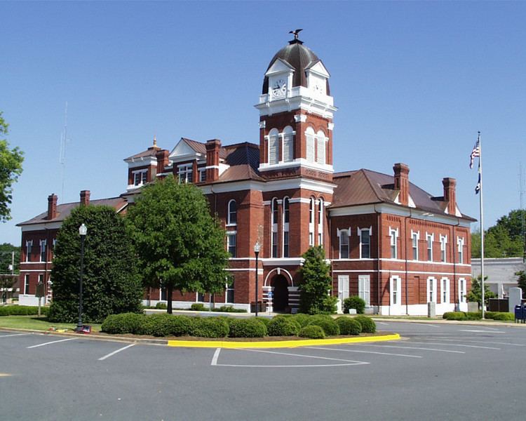
In 1864, during the Civil War, General William T. Sherman skirmished and then paused in Sandersville during his March to the Sea. Brief resistance to the advancing Union forces was centered on the courthouse. As they left, Sherman's troops burned both it and jail, but left the rest of the town intact. A new Washington County Courthouse was built in 1869.
The Sandersville Railroad was built in 1893.
Economy
The economy of Sandersville was based on agriculture, particularly cotton, for many years. In the 1950s, an industry developed based on the mining and processing of kaolin found in the area.
Washington County School District
The Washington County School District holds pre-school to grade twelve, and consists of a primary and elementary school, a middle school, and a high school. The district has 220 full-time teachers and over 3,821 students.
Private education
Higher education
Newspaper
Sandersville has two newspapers: The Sandersville Progress and "The Spotlight". They both are published weekly. The Sandersville Progress began publication in 1870.