
Length 266.1 km | ||
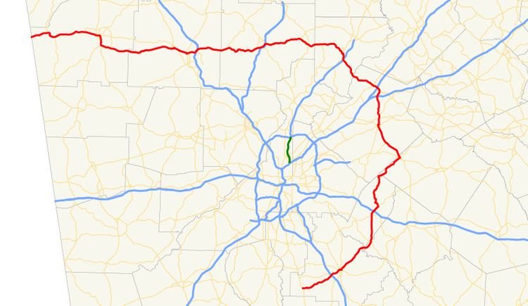 | ||
State Route 20 (SR 20) is a 165.345-mile-long (266.097 km) state highway roughly in the shape of a capital J rotated ninety degrees to the left, which travels through portions of Floyd, Bartow, Cherokee, Forsyth, Gwinnett, Walton, Rockdale, Newton, and Henry counties in the northwestern and north-central parts of the U.S. state of Georgia. Its counterclockwise, or western terminus is at the Alabama state line in Floyd County, and its clockwise, or eastern terminus occurs at its interchange with Lower Woolsey Road southwest of Hampton in Henry County south-southeast of the Atlanta Motor Speedway.
Contents
- Map of GA 20 Georgia USA
- Route description
- Traffic
- National Highway System
- History
- Cartersville spur route
- References
Map of GA-20, Georgia, USA
Route description
From the Alabama state line, SR 20 proceeds east through central Floyd County into the city of Rome, and is concurrent with US 27, SR 1, and SR 53 through downtown Rome. The highway leaves Rome to the east, concurrent with US 411, bisecting Floyd County, and then enters and bisects Bartow County, still concurrent with US 411 until just north of Cartersville (US 41 is briefly concurrent in Cartersville as well), after which SR 20 continues eastward on its own. The highway intersects I-75 north of Cartersville, and continues to head east, passing Lake Allatoona to its north, and entering Cherokee County. SR 20 heads east into central Cherokee County and through its county seat in Canton, and has a brief concurrency with I-575/SR 5, before continuing east into Forsyth County. In central Forsyth County, the highway dips southeast to pass to the south of Sawnee Mountain and heads through Cumming, crossing US 19 and SR 400, and heading on into Gwinnett County, passing to the south of Lake Lanier. SR 20 then turns south after an interchange with I-985/US 23/SR 365, crossing I-85 shortly thereafter. The road also has provides access to SR 316, which leads to Athens.
SR 20 continues southward through Lawrenceville and heads into Walton County and through Loganville, paralleling the Gwinnett–Walton County line, before crossing into Rockdale County and meeting I-20/US 278/SR 12 in Conyers. Likely to help alleviate driver confusion due to two identically-numbered highways meeting, the highway is usually referred to at this point as SR 138, with which it travels concurrent through Conyers. SR 20 continues south and then southwest to the Henry County seat of McDonough, where it briefly travels concurrent with SR 81. SR 81 departs to the west after the highways cross I-75 at exit 218. The portion of SR 20 between the western end of the SR 81 concurrency and Lower Woolsey Road, the highway's clockwise/eastern terminus, has recently been widened from two lanes to four, including a new southern bypass of the city of Hampton, and more controlled access at US 19/US 41. The primary purpose of the widening is to facilitate the flow of traffic to and from the Atlanta Motor Speedway located near the highway's eastern terminus.
Traffic
The Georgia Department of Transportation average annual daily traffic (AADT) numbers for the year 2011 show a variety of daily averages across SR 20. The traffic load on the highway starts at its lowest daily average load as the route starts into Floyd County, where numbers hover around 5,400 vehicles per day. These averages increase rapidly as the highway approaches Rome, going from around 12,000 vehicles to a peak of 38,000 vehicles in downtown Rome. As SR 20 becomes concurrent with US 27/SR 1, the numbers decrease to an average of 32,000, and then decrease more rapidly to around 15,000 as SR 20 heads east out of Rome. The vehicle load stays in that area all the way through Floyd County and into Bartow County, as the highway is the main west-to-east thoroughfare between Rome and Cartersville. In Cartersville, where the highway is concurrent with US 41, the vehicle count reaches a zenith of just over 41,000, but then drops off sharply as the highway heads into rural Cherokee County, dipping just below 10,000 before increasing again to near 24,000 vehicles per day as it approaches I-575/SR 5. On the portion of the highway that is concurrent with I-575/SR 5, the highway sees its maximum vehicle load of just over 54,000 vehicles, again dropping rapidly east of I-575/SR 5, going from around 24,000 down to 11,000, and further down to around 10,000 as the Forsyth County line is reached.
Numbers start to creep up again as the Forsyth county seat of Cumming approaches, going from 10,000 to over 22,000 vehicles, cresting at 37,000 vehicles south of Cumming, as the route feeds traffic onto US 19/SR 400 southbound into Atlanta. Averages stabilize around 20,000 vehicles per day as SR 20 heads into Gwinnett County, briefly cresting again at over 41,000 vehicles around I-985, and dipping to around 30,000 vehicles around I-85. South of Lawrenceville, numbers then start to decrease once more from around 22,000 down to 14,000 around Loganville, and dip down into average of just over 8,000 in rural Walton County. Until the highway reaches Conyers, average numbers see lows of 6,800 in Rockdale County, increasing again to just over 31,000 in and around Conyers and I-20. Rapidly decreasing once more to around 7,600 vehicles per day in Newton and northern Henry counties, another high is reached in the vicinity of I-75 with just over 28,000 vehicles per day, before the highway reaches its eastern terminus in Hampton with average traffic loads just over 12,000 vehicles per day.
National Highway System
The following segments of SR 20 are the included as part of the National Highway System, a system of routes determined to be the most important for the nation's economy, mobility and defense:
History
The first portions of the roadway that are signed as SR 20 today makes its appearance on Georgia state road maps in 1920, which show the portion of the highway from the Alabama state line through Rome to Carterville signed as SR 4. The section from Cartersville to Cumming traveling east across north Georgia is missing at the time. The next extant portion was the section traveling southeast from Cumming to Buford, which appears to be unsigned in 1920, and the piece between Buford and Lawrenceville, which is signed as SR 13. The entire remainder of the current route was not yet in existence in 1920. In 1921, the section between Cumming and Buford is shown as being signed as SR 68, and by 1929, the existing portion from the Alabama state line to Cartersville had been signed as SR 20, concurrent with US 41W.
By early in 1932, Georgia state road maps show a new graded, but unimproved 18.5 miles (29.8 km) section signed as SR 20 between Rydal in Bartow County, and Canton in Cherokee County, which corresponds to today's routing of SR 140 in the area, and which met SR 20 at its intersection with today's SR 108. In addition, a shorter 10.2 miles (16.4 km) portion of the highway between Lawrenceville and Loganville also made its first appearance. The existing portion of the highway between just west of Rome to Cartersville appears as having been finished with hard surface, and the SR 13 section between Buford and Lawrenceville appeared in the same finished condition.
Just a month later, the 23.8 miles (38.3 km) connection between Canton and Cumming is shown as graded but unimproved, and is signed as SR 20. The segments from Cumming through Buford and Lawrenceville to Loganville had also been re-signed as SR 20, and by the middle of the year, the route had been extended yet again with the addition of the portion from Loganville to Conyers. Motorists were now able to travel from the Alabama state line to Loganville, using SR 61, which was concurrent with SR 20 by October in 1934, to connect to Rydal in lieu of the still-missing portion between Cartersville and Canton.
Nearly two years later saw the next extension, taking the highway from Conyers to McDonough. Outside of some small surface improvements east of Canton, the next significant change in the highway was the appearance in early 1941 of the straight west-to-east 23.4 miles (37.7 km) connection between north of Cartersville and Canton, which was initially signed as SR 20 Spur (between US 41 and SR 61) and SR 113, and redesignated to be part of SR 20 by 1943.
By 1953, no additions to the signed length of the highway had been made, but the roadway connecting McDonough with Hampton had been constructed. In addition, surface conditions had been improved to feature hard surface for the entire length of the highway, with the exception of portions between Cartersville and Canton, south of Loganville, and north of McDonough. It was 1960 before this final piece of the highway, between McDonough and Hampton, had been finished and designated as part of SR 20. The entirety of the route was now extant, and was covered by hard surface
In 2003, following years of complaints regarding traffic from Atlanta Motor Speedway, the final 10 miles (16 km) being designated as the O. Bruton Smith Parkway, and widened to a four-lane divided highway status in preparation for the 2005 Bass Pro Shops MBNA 500.
Cartersville spur route
State Route 20 Spur (SR 20 Spur) is a 4.264-mile-long (6.862 km) spur route of SR 20. It travels from SR 20, just east of its interchange with Interstate 75 (I-75) north of Cartersville, south to Allatoona Dam. The highway, along with nearby Allatoona Dam road, formed the two segments of State Route 294.
By 1953, SR 20 Spur had been constructed and was signed as SR 294.
The entire route is in Bartow County.