
Website www.co.henry.ga.us Founded 15 May 1821 | Area 846.9 km² Population 211,128 (2013) Unemployment rate 6.0% (Apr 2015) | |
 | ||
Points of interest Heritage Park, Alexander Park, Memorial Park, Clark Community Park, McBrayer Park | ||
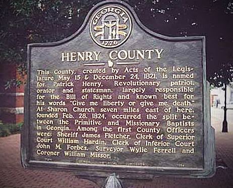
Henry County is a county located in the north central portion of the U.S. state of Georgia. Per the 2014 census estimate, the population of Henry County is 213,869. The county seat is McDonough. The county was named for Patrick Henry, Revolutionary War firebrand and champion of individual rights, to whom the slogan "give me liberty, or give me death" is attributed.
Contents
- Map of Henry County GA USA
- History
- Geography and transportation
- Government
- Adjacent counties
- Transit systems
- 2000 Census
- 2010 census
- Economy
- Media
- Education
- Enriched Virtual Program
- Alternative schools
- Private schools
- Higher education
- Cities
- Census designated place
- References
Map of Henry County, GA, USA
Henry County is part of the Atlanta-Sandy Springs-Roswell, GA Metropolitan Statistical Area. It is home to the Atlanta Motor Speedway in Hampton. The Henry County Courthouse (McDonough, Georgia) is listed on the National Register of Historic Places. In 1995, Henry County was the 6th fastest growing county in the United States.
History
Henry County, Georgia was created by the Georgia State Legislature in 1821 from land acquired from the Creek Indian Nation by the First Treaty of Indian Springs. Henry's original land area was much larger than it is today, stretching from near Indian Springs (present-day Indian Springs State Park) in the south to the Chattahoochee River near Sandy Springs in the north; encompassing most of present-day Metropolitan Atlanta. Before one year passed the size of the County was diminished through the separation of land areas which, in whole or in part, became present day DeKalb, Fulton, Fayette and Newton Counties. Later divisions resulted in Clayton, Spalding, Rockdale and Butts Counties.
In the beginning Henry County was a virgin wilderness, having just been ceded from the Creek Nation. Prior to 1821, the Creeks and a few trappers and traders were the only residents of this area. The Creek Indians left their mark through place names, a few small Indian Mounds scattered around the County and through the arrowheads and broken pottery which can be found throughout Henry County.
Jesse Johnson, son of John Johnson and great-grandfather of U.S. President Lyndon Baines Johnson, was a "first settler" of Henry County. He was a prosperous farmer, sheriff (1822–1835), and judge, before he fled to Alabama.
Geography and transportation
According to the U.S. Census Bureau, the county has a total area of 327 square miles (850 km2), of which 322 square miles (830 km2) is land and 4.4 square miles (11 km2) (1.4%) is water.
The vast majority of Henry County is located in the Upper Ocmulgee River sub-basin of the Altamaha River basin, with just a very small western corner, west of Hampton, located in the Upper Flint River sub-basin of the ACF River Basin (Apalachicola-Chattahoochee-Flint River Basin).
Government
The Henry County Board of Commissioners is are responsible for administering county government to residents. A chairman is elected countywide by residents and is the county's chief executive. June Wood is the current county chair. She is the first African- American to serve in the position since being elected in a December 2016 run- off election. As of January 2017, the following individuals serve the county on the Board of Commissioners:
Chair: June Wood District 1: Johnny Wilson District 2: Dee Clemmons District 3: Gary Barham District 4: Blake Prince District 5: Bruce Holmes
Adjacent counties
Transit systems
2000 Census
As of the census of 2000, there were 119,341 people, 41,373 households, and 33,305 families residing in the county. The population density was 370 people per square mile (143/km²). There were 43,166 housing units at an average density of 134 per square mile (52/km²). The racial makeup of the county was 81.38% White, 14.68% Black or African American, 0.23% Native American, 1.76% Asian, 0.04% Pacific Islander, 0.79% from other races, and 1.13% from two or more races. 2.26% of the population were Hispanic or Latino of any race. Census Estimates from the 2008 American Community Survey indicate that the African-American population is 32.6%.
There were 41,373 households out of which 42.90% had children under the age of 18 living with them, 66.40% were married couples living together, 10.30% had a female householder with no husband present, and 19.50% were non-families. 15.40% of all households were made up of individuals and 4.00% had someone living alone who was 65 years of age or older. The average household size was 2.87 and the average family size was 3.19.
In the county, the population was spread out with 29.20% under the age of 18, 7.40% from 18 to 24, 34.90% from 25 to 44, 21.00% from 45 to 64, and 7.40% who were 65 years of age or older. The median age was 33 years. For every 100 females there were 97.30 males. For every 100 females age 18 and over, there were 93.80 males.
The median income for a household in the county was $57,309, and the median income for a family was $61,607. Males had a median income of $41,449 versus $29,211 for females. The per capita income for the county was $22,945. About 3.70% of families and 4.90% of the population were below the poverty line, including 5.50% of those under age 18 and 7.80% of those age 65 or over.
2010 census
As of the 2010 United States Census, there were 203,922 people, 70,255 households, and 54,445 families residing in the county. The population density was 633.0 inhabitants per square mile (244.4/km2). There were 76,533 housing units at an average density of 237.6 per square mile (91.7/km2). The racial makeup of the county was 55.0% white, 36.9% black or African American, 2.9% Asian, 0.3% American Indian, 0.1% Pacific islander, 2.4% from other races, and 2.4% from two or more races. Those of Hispanic or Latino origin made up 5.8% of the population. In terms of ancestry, 10.7% were American, 9.3% were Irish, 9.2% were German, and 8.2% were English.
Of the 70,255 households, 45.6% had children under the age of 18 living with them, 55.9% were married couples living together, 16.4% had a female householder with no husband present, 22.5% were non-families, and 18.5% of all households were made up of individuals. The average household size was 2.89 and the average family size was 3.29. The median age was 35.3 years.
The median income for a household in the county was $63,923 and the median income for a family was $70,972. Males had a median income of $50,198 versus $39,785 for females. The per capita income for the county was $25,773. About 6.3% of families and 8.3% of the population were below the poverty line, including 11.7% of those under age 18 and 5.8% of those age 65 or over.
Economy
Goya Foods has its Atlanta offices in an unincorporated area near McDonough.
Media
WKKP AM is the local radio media outlet. It broadcasts 24 hours a day on 1410 AM, and has a classic country format.
The Henry Herald and the Henry County Times are the local county news print media.
Education
Local public schools are run by the Henry County School System.
Enriched Virtual Program
Alternative schools
Private schools
Higher education
Mercer University has a Regional Academic Center in McDonough. The center, opened in 2003, offers programs through the university's College of Continuing and Professional Studies and Mercer's Tift College of Education. Clayton State University and Gordon College also offer a range of college courses at the Academy for Advanced Studies in McDonough.
Southern Crescent Technical College's Henry County Center (in McDonough) offers programs in Allied Health, Business Technology, Logistics and Supply Chain Management, Computer Information Systems, Personal Services, Public Safety, and Drafting Technology.