
Length 33.6 km | ||
 | ||
Counties | ||
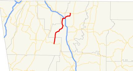
State Route 201 (SR 201) is a 21.1-mile-long (34.0 km) state highway in the northwestern part of the U.S. state of Georgia. Its routing runs from Villanow, in Walker County northeast to Varnell, in Whitfield County.
Contents
Map of GA-201, Georgia, USA
Route description
SR 201 begins at an intersection with SR 136 in Villanow. It heads north-northeast, through portions of the Chattahoochee National Forest, until it crosses into Whitfield County. The highway continues to the north-northeast, and passes through the unincorporated community of Mt. Vernon. Shortly afterward, SR 201 passes the western edge of Rocky Face. There, it intersects US 41/US 76/SR 3 (Chattanooga Road), and the four highways run concurrent north to Tunnel Hill, where SR 201 departs to the northeast, while US 41/US 76/SR 3 continue on Chattanooga Road. Just past the northeastern edge of Tunnel Hill is an interchange with Interstate 75 (I-75; Larry McDonald Memorial Highway). SR 201 continues heading northeast until it meets its northern terminus, an intersection with SR 2 in Varnell.
SR 201 is not part of the National Highway System, a system of roadways important to the nation's economy, defense, and mobility.