
 | ||
The geology of Iceland is unique and of particular interest to geologists. Iceland lies on the divergent boundary between the Eurasian plate and the North American plate. It also lies above a hotspot, the Iceland plume, which is believed to have caused the formation of Iceland itself, the island first appearing over the ocean surface about 16 to 18 million years ago. The result is an island characterised by repeated volcanism and geothermal phenomena such as geysers.
Contents
- Opening of the North Atlantic
- Glaciations
- Holocene changes and volcanism
- Volcanic deposits
- Intrusive rocks
- Sedimentary deposits
- Active tectonics
- Glacial Geology
- Human impact and natural catastrophes
- Current climate change
- References
The eruption of Laki in 1783 caused much devastation and loss of life, leading to a famine that killed approximately 25% of the island's human population and resulting in a drop in global temperatures, as sulfur dioxide was spewed into the Northern Hemisphere. This caused crop failures in Europe and may have caused droughts in India. The eruption has been estimated to have killed over six million people globally, making it one of the deadliest volcanoes, with Tambora being number one.
In the period 1965 to 1969 the new island of Surtsey was created on the southwest coast by a volcanic eruption.
Opening of the North Atlantic
Glaciations
Holocene changes and volcanism
Volcanic deposits
Intrusive rocks
Sedimentary deposits
One of the rare examples of sedimentary rocks in Iceland is the sequence of marine and non-marine sediments present on the Tjörnes Peninsula in northern Iceland. These Pliocene and late Pleistocene deposits are composed of silt and sandstones, with fossils preserved in the lower layers. The primary fossil types found in the Tjörnes beds are marine mollusc shells and plant remains (lignite).
Active tectonics
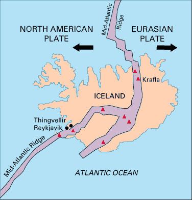
The tectonic structure of Iceland is characterized by various seismically and volcanically active centers. Iceland is bordered to the south by the Reykjanes Ridge segment of the Mid-Atlantic Ridge and to the north by the Kolbeinsey Ridge. Rifting in the southern part of Iceland is focused in two main parallel rift zones. The Reykjanes Peninsula Rift in SW Iceland is the landward continuation of the Reykjanes Ridge that connects to the Western Volcanic Zone (WVZ). The more active Eastern Volcanic Zone (EVZ) represents a rift jump, although it is unclear how the eastward propagation of the main rifting activity has occurred. The offset between the WVZ and the EVZ is accommodated by the South Iceland Seismic Zone, an area characterized by high earthquake activity. The EVZ transitions northward into the Northern Volcanic Zone (NVZ), which contains Krafla volcano. The NVZ is connected to the Kolbeinsey Ridge by the Tjörnes Fracture Zone, another major center of seismicity and deformation.
Glacial Geology
Glaciers cover approximately 11% of Iceland, the largest of which is Vatnajökull. As many glaciers overlie active volcanoes, subglacial eruptions can pose hazards due to sudden floods produced by glacial meltwater, known as jökulhlaups. Icelandic glaciers have generally been retreating over the past 100 years, with Vatnajökull having lost as much as 10% of its volume.