
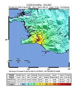
Magnitude 6.1 Mw Epicenter 63.992°N, 21.014°W Date 29 May 2008 | Depth 10 km (6.2 mi) Type Strike-slip Max. intensity VIII (Severe) | |
 | ||
Similar 2008 Peloponnese earthquake, 2008 Chechnya earthquake, 2008 Illinois earthquake, 2008 Lincolnshire earthquake, 2008 Kyrgyzstan earthquake | ||
The 2008 Iceland earthquake was a doublet earthquake that struck on May 29 at 15:46 UTC in southwestern Iceland. The recorded magnitudes of the two main quakes were 5.9 Mw and 5.8 Mw, respectively, giving a composite magnitude of 6.1Mw. There were no human fatalities, but 30 injuries were reported and a number of sheep were killed. The epicenter of the earthquake was between the towns of Hveragerði and Selfoss, about 45 kilometers (28 mi) east-southeast of the capital, Reykjavík. It was the strongest earthquake to hit Iceland since the summer of 2000.
Contents
CharacteristicsEdit
Iceland straddles the mid-Atlantic ridge where the Eurasian and North-American tectonic plates move away from each other. Volcanic activity is common along such divergent boundaries but strong earthquakes are rare. In Iceland the ridge is somewhat off-set, creating two transform faults where plates move horizontally along each other. One is in the north of the country and one in the south; the strongest Icelandic earthquakes happen along those transform faults. The 29 May quake is classified by geologists as typical Suðurlandsskjálftar (literally: Southern Iceland quakes), which happen on the southern fault.
DamageEdit
Unlike the quakes in the summer of 2000, the 29 May quake happened in the most densely populated part of the South Iceland district. The population of the affected area is about 12,000 and it includes the towns of Selfoss and Hveragerði as well as Eyrarbakki, Stokkseyri and Þorlákshöfn. Many farms were also affected.