
 | ||
Geography of the Federated States of Micronesia (FSM), a country located in the western Pacific Ocean, and in the Micronesia cultural and ecological sub-region of Oceania.
Contents
Geography
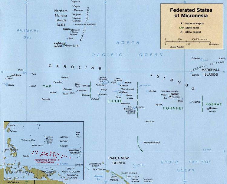
The country consists of 607 islands extending 1,800 miles (2,900 km) across the Caroline Islands Archipelago. They are east of the Philippine Islands, and north of the island of New Guinea. The federal capital is Palikir, on Pohnpei island.
The 607 islands are grouped into four states, and east to west are:
Separated from the main islands in southern Pohnpei State are the two islands of Nukuoro and Kapingamarangi. They are geographically part of the Micronesia region, but are linguistically and culturally part of the Polynesia region. The indigenous languages spoken on these two islands are in the Samoic family of Polynesian languages.
Location
The Federated States of Micronesia are an island group in the Caroline Islands Archipelago of the western Pacific Ocean, in the Micronesia sub-region of Oceania.
Located about three-quarters of the way from Hawaii to Indonesia at Geographic coordinates: 6°55′N 158°15′E
Map references are Oceania and Micronesia.
Dimensions
Area:
The country's total area is four times the size of Washington, D.C. in the U.S.
Coastline: The combined coastlines of the country's 607 islands equal 6,112 kilometres (3,798 mi).
Maritime claims:
Terrain
The country's 607 islands vary from high mountainous ones to low coral atolls. Geologically, there are volcanic rock outcroppings on the islands of Pohnpei, Kosrae, and Truk.
Elevation extremes
Extreme points
The extreme points of the Federated States of Micronesia, the landforms that are farther north, south, east or west — than any other location in the country.
Environment
Environment—current issues: Overfishing, climate change, land and water pollution.
Environment—international agreements:
Land use
Products: Tropical woods and lumber, marine products, deep-seabed minerals, surface mined phosphate.
Climate
The Federated States of Micronesia enjoys a tropical climate, with quite even, warm temperatures throughout the year.
Precipitation is generally plentiful, with heavy year-round rainfall. Pohnpei reputedly is one of the wettest places on earth, with up to 330 inches (8.4 m) of rain per year. Nevertheless, drought conditions do occur periodically throughout FSM, especially when the El Niño condition moves into the Western Pacific, when groundwater supplies can dwindle to emergency proportions.
Natural hazards
Tropical typhoons are an annual threat, from June to December. The country is located on southern edge of the typhoon belt, with occasionally severe damage, particularly to the low-lying atolls.
Tsunamis and rising sea levels are other natural threats.