
Total islands 40 Length 6 km (3.7 mi) Population 372 (2007) | Area 40 km (15 sq mi) Languages Nukuoro | |
 | ||
Johnny rudolph tells a nukuoro creation story in english
Nukuoro is an atoll in the Federated States of Micronesia.
Contents
- Johnny rudolph tells a nukuoro creation story in english
- Map of Nukuoro Atoll Federated States of Micronesia
- Population
- History
- References
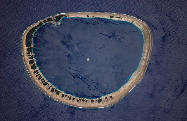
Map of Nukuoro Atoll, Federated States of Micronesia
It is a municipality of the state of Pohnpei, Federated States of Micronesia. Except for Kapingamarangi, it is the southernmost atoll of the country. They both are Polynesian outliers. As of 2007, Nukuoro had a population of 372, though several hundred Nukuorans live on Pohnpei. The total area, including the lagoon, is 40 km2 (15 sq mi), with a land area of 1.7 km2 (0.66 sq mi), which is divided among more than 40 islets that lie on the northern, eastern, and southern sides of the lagoon. By far, the largest islet is Nukuoro islet, which is the center of population and the capital of the municipality.
The lagoon is 6 km (3.7 mi) in diameter. Fishing, animal husbandry, and agriculture (taro and copra) are the main occupations. A recent project to farm black pearl oysters has been successful at generating additional income for the island's people.
Nukuoro is remote. It has no airstrip, and a passenger boat calls irregularly only once every few months. The island has no tourism except for the occasional visit by passing sailing yachts. There is a 4-room schoolhouse but children over the age of 14 must travel to Pohnpei to attend high school.
Population
The inhabitants speak Nukuoro, which is a Polynesian language related to Kapingamarangi, Rennellese and Pileni languages. Nukuoro and Kapingamarangi constitute parts of the "Polynesian outlier" cultures, lying well outside the Polynesian Triangle.
Locals tell that the first people who came to settle on Nukuoro in the 18th century were a man and crew of six from Tokelau in the South Pacific.
History
First sighting recorded by Europeans was by Spanish naval officer Juan Bautista Monteverde on 18 February 1806 commanding the frigate San Rafael of the Royal Company of the Philippines. They have therefore appeared in the maps as the Monteverde Islands for a long time.