
 | ||
The geography of Bolivia is unique among the nations of South America. Bolivia is one of two landlocked countries on the continent (the other being Paraguay), and Bolivia is more urban (67%) than rural (23%). The main features of Bolivia's geography include the Altiplano, a highland plateau of the Andes, and Lake Titicaca, the highest navigable lake on Earth, which is shared with Peru.
Contents
The most prominent feature of the Altiplano is the large lake at its northern end, Lake Titicaca. At 3,811 m (12,503 ft) above sea level, it is the highest commercially navigable body of water in the world. With a surface area of 9,064 km2 (3,500 sq mi), it is larger than Puerto Rico and is South America's second largest lake by surface area. Lake Titicaca is also deep, about 370 m (1,214 ft) at its deepest, with an average depth of 215 m (705 ft); its volume of water is large enough to maintain a constant temperature of 10 °C (50 °F). The lake actually moderates the climate for a considerable distance around it, making crops of maize and wheat possible in sheltered areas.
Lake Titicaca drains southward through the slow-moving, reed-filled Desaguadero River to Lake Poopó. In contrast to the freshwater Lake Titicaca, Lake Poopó is salty and shallow, with depths seldom more than 4 m (13 ft).
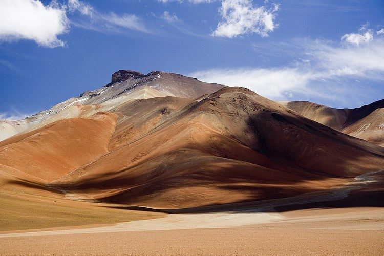
The Cordillera Occidental is a chain of dormant volcanoes and solfataras, volcanic vents emitting sulfurous gases. Bolivia's highest peak, the snowcapped Nevado Sajama 6,542 m (21,463 ft), is located here. The entire cordillera is of volcanic origin and an extension of the volcanic region found in southern Peru. Most of the northern part of this range has an elevation of about 4,000 m (13,123 ft); the southern part is somewhat lower. Rainfall, although scanty everywhere, is greater in the northern half, where the land is covered with scrub vegetation. The southern area receives almost no precipitation, and the landscape consists mostly of barren rocks. All of the Cordillera Occidental region is sparsely populated, and the south is virtually uninhabited.
The Altiplano, the high plateau between the previous range and the Cordillera Oriental, comprises four major basins formed by mountainous spurs that jut eastward from the Cordillera Occidental about halfway to the Cordillera Oriental. Along the Altiplano's eastern side is a continuous flat area, which has served as Bolivia's principal north-south transport corridor since colonial times. The entire Altiplano was originally a deep rift between the cordilleras that gradually filled with highly porous sedimentary debris washed down from the peaks. This sedimentary origin explains its gradual slope from north to south; greater rainfall in the north has washed a larger quantity of debris onto the platform floor.
Rainfall in the Altiplano decreases toward the south, and the scrub vegetation grows more sparse, eventually giving way to barren rocks and dry red clay. The land contains several salt flats, the dried remnants of ancient lakes. The largest of these - and the world's largest salt concentration - is the Uyuni Saltpan, which covers over 9,000 square kilometers. The salt is more than five meters deep in the centre of this flat. In the dry season, the lake bed can be traversed by heavy trucks. Near the Argentine border, the floor of the Altiplano rises again, creating hills and volcanoes that span the gap between the eastern and western cordilleras of the Andes.
The much older Cordillera Oriental enters Bolivia on the north side of Lake Titicaca, extends southeastward to approximately 17 south latitude, then broadens and stretches south to the Argentine border. The northernmost part of the Cordillera Oriental, the Cordillera Real, is an impressive snow-capped series of granite mountains. Some of these peaks exceed 6,000 m (19,685 ft) and two - Illimani 6,424 m (21,076 ft), which overlooks the city of La Paz, and Illampu 6,424 m (21,076 ft) - have large glaciers on their upper slopes. South of 17 south latitude, the range changes character. Called the Cordillera Central here, the land is actually a large block of the Earth's crust that has been lifted and tilted eastward. The western edge of this block rises in a series of steep cliffs from the Altiplano. The backbone of the cordillera is a high, rolling plain, with elevations from 4,200 m (13,780 ft) to 4,400 m (14,436 ft), interspersed with irregularly spaced high peaks. Too high to be exploited for large-scale commercial grazing, this area takes its name from the predominant vegetation type, the puna.
Valleys
The northeastern flank of the Cordillera Real is known as the Yungas, from the Aymara and Quechua word yunka meaning "warm valley." The steep, almost inaccessible slopes and peaks of this mainly semitropical valley area northeast of La Paz offer some of the most spectacular scenery in Bolivia. Rainfall is heavy, and lush vegetation clings to the sides of narrow river valleys. The land is among the most fertile in Bolivia, but poor transport has hindered its agricultural development. The government attempted to build a railway through the Yungas in 1917 to connect La Paz with the eastern lowlands. The railway was abandoned, however, after completion of only 150 kilometres.
The eastern slopes of the Cordillera Central descend gradually in a series of complex north-south ranges and hills. Rivers, draining to the east, have cut long narrow valleys; these valleys and the basins between the ranges are favourable areas for crops and settlement. Rich alluvial soils fill the low areas, but erosion has followed the removal of vegetation in some places. The valley floors range from 2,000 to 3,000 metres above sea level, and this lower elevation means milder temperatures than those of the Altiplano. Two of Bolivia's most important cities, Sucre and Cochabamba, are located in basins in this vast region.
Lowlands
The eastern lowlands include all of Bolivia north and east of the Andes. Although comprising over two-thirds of the national territory, the region is sparsely populated and, until recently, has played a minor role in the economy.
Differences in topography and climate separate the lowlands into three areas. The flat northern area, made up of Beni and Pando Departments and the northern part of Cochabamba Department, consists of rainforest. Because much of the topsoil is underlain by claypan, drainage is poor, and heavy rainfall periodically converts vast parts of the region to swamp. The central area, comprising the northern half of Santa Cruz Department, has gently rolling hills and a drier climate than the north. Forests alternate with savanna, and much of the land has been cleared for cultivation. Santa Cruz, the largest city in the lowlands, is located here, as are most of Bolivia's petroleum and natural gas reserves. The southeastern part of the lowlands is part of the Gran Chaco. Virtually rainless for nine months of the year, this area becomes flooded for the three months of heavy rains. The extreme variation in rainfall supports only thorny scrub vegetation and cattle grazing, although recent discoveries of natural gas and petroleum near the foothills of the Andes have attracted some settlers to the region.
Most of Bolivia's important rivers are found in the water-rich northern parts of the lowlands, particularly in the Alto Beni (Upper Beni), where the land is suitable for crops such as coffee and cacao. The northern lowlands are drained by wide, slow-moving rivers, the three largest of which—the Mamoré, Beni, and Madre de Dios—all flow northward into the Madeira River in Brazil and eventually into the River Amazon. Riverboats along the Beni and the Mamoré carry both passenger and freight traffic; rapids on the Madeira prevent river traffic farther into Brazil. Near the Paraguayan border, shallow sandy streams carry the seasonal runoff into the Pilcomayo or Paraguay rivers. Also, the Pantanal, the world's largest wetland of any kind, has some of its area in Bolivia.
Despite the fact that eastern Bolivia is described a lowland in when seeing the general topography of the country there are mountains and mountain ranges well beyond the Andes. The most notable of these mountains are the forested Serranías Chiquitanas in eastern Santa Cruz Department.
Climate
The climate of Bolivia varies drastically from one ecoregion to the other, from the tropics in the eastern llanos to polar climates in the western Andes. The summers are warm, humid in the east and dry in the west, with rains that often modify temperatures, humidity, winds, atmospheric pressure and evaporation, giving place to very different climates. When the climatological phenomenon known as El Niño takes place, it provokes great alterations in the weather. Winters are very cold in the west, and it snows around the mountain ranges, while in the western regions, windy days are more usual. The autumn is dry in the non-tropical regions.
Antipodes
Bolivia is antipodal to a few land areas. La Paz is antipodal to the disputed Paracel Islands. The easternmost part of the country is opposite most of the northern lobe of Luzon Island in the Philippines, including the city of Baguio, and the southwestern corner is opposite the southern part of Macau and an adjacent bit of mainland China to the city of Yangjiang.
Statistics
Geographic coordinates: 17°00′S 65°00′W
Terrain: rugged Andes Mountains with a highland plateau (Altiplano), hills, lowland plains of the Amazon Basin
Elevation extremes:
lowest point: Rio Paraguay 90 m
highest point: Nevado Sajama 6,542 m (21,463 ft)
Natural resources: tin, natural gas, petroleum, zinc, tungsten, antimony, silver, iron, lead, gold, timber, hydro-power
Land borders: Argentina (942 km), Brazil (3,403 km), Chile (942 km), Paraguay (753 km), Peru (1,212 km)
Land use:
arable land: 3.97%
permanent crops: 0.20%
other: 95.83% (2012)
Irrigated land: 1,282 km² (2003)
Total renewable water resources: 622.5 cu km (2011)
Freshwater withdrawal (domestic/industrial/agricultural:
total: 2.64 km³/yr (25%/14%/61%)
per capita: 305.8 m³/yr (2005)
Natural hazards: flooding in the northeast (March–April)
Environment - current issues: the clearing of land for agricultural purposes and the international demand for tropical timber are contributing to deforestation; soil erosion from overgrazing and poor cultivation methods (including slash-and-burn agriculture); desertification; loss of biodiversity; industrial pollution of water supplies used for drinking and irrigation
Environment - international agreements:
party to: Biodiversity, Climate Change, Climate Change-Kyoto Protocol, Desertification, Endangered Species, Hazardous Wastes, Law of the Sea, Marine Dumping, Nuclear Test Ban, Ozone Layer Protection, Ship Pollution, Tropical Timber 83, Tropical Timber 94, Wetlands
signed, but not ratified: Environmental Modification, Marine Life Conservation
Geography - note: landlocked; separated from the Pacific Ocean via Chile. Bolivia had a coastline, but its former coastline is now Chilean territory because of the War of the Pacific. Bolivia shares control of Lago Titicaca, world's highest navigable lake (elevation 3,805 m), with Peru