
Country Malaysia Time zone MST (UTC+8) Elevation 3.99 m Postal code 11700 | Website mbpp.gov.my Area 151.7 km² Local time Saturday 10:41 PM | |
 | ||
Weather 29°C, Wind W at 11 km/h, 76% Humidity University University of Science, Malaysia | ||
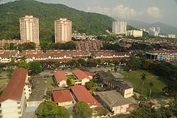
Gelugor is a southern suburb of George Town on Penang Island, Malaysia. Named after a plant species, Gelugor lies along the eastern seaboard of Penang Island between Jelutong and Sungai Dua.
Contents
Map of Gelugor, Penang, Malaysia
Gelugor had been populated as early as the late 18th century by Malay fishermen who arrived here from Sumatra. The area was then cleared for agricultural plantations by David Brown, a partner of Captain Francis Light.
Urbanisation of the area began in earnest in the 1960s, when residential estates were established within the area. Gelugor gradually turned into a suburb of George Town, helped by its strategic location right in the middle between George Town proper and Bayan Lepas to the south. In 1969, Universiti Sains Malaysia was founded at Gelugor and is now one of the top Malaysian public universities.
In recent decades, Gelugor has assumed increased importance. In addition to hosting Penang Island's first university, the Penang Bridge, completed in 1985 to link Penang Island and the Malay Peninsula, has its island terminus at Gelugor.
Etymology
Gelugor was named after Garcinia atroviridis, known in Malay as asam gelugor. Widely endemic in the Malay Peninsula, this species is especially cultivated on Penang Island for its medicinal properties.
History
Gelugor was one of the first areas of Penang Island to be inhabited. Fishermen had moved into the area from Sumatra in the 18th century, predating Captain Francis Light's founding of Penang Island in 1786. They settled around the mouth of the Gelugor River (Malay: Sungai Gelugor).
Soon after Light came ashore in what is now George Town in 1786, his Scottish partner, David Brown, cleared the jungles around Gelugor to make way for agricultural purposes, including spice and coconut plantations. Brown also brought in labourers from India to work in the estates. He eventually became the largest landowner on Penang Island in the early 19th century.
Up until the end of World War II, Gelugor remained a rural area. Prior to the war, the British Army converted one of David Brown's houses into the Glugor Barracks, to be renamed later as Minden Barracks. The army camp was occupied by the Imperial Japanese Army during the war. It was again put in use during the Malayan Emergency and the Indonesian Confrontation, before being closed for good in 1971 following the withdrawal of all British armed forces from Southeast Asia.
The development of residential estates at Gelugor began in the 1960s, originally to house civil servants. Also in the 1960s, a proposal to establish Penang's first university was mooted. Eventually, the Penang University (Malay: Universiti Pulau Pinang) was founded in 1969, before being relocated to the former Minden Barracks in 1971. The university has since been renamed Universiti Sains Malaysia, now one of the foremost public universities in Malaysia.
In 1985, the 13.5 km long Penang Bridge that connects Gelugor with the Malay Peninsula was completed. The bridge has indirectly boosted urbanisation at Gelugor, which also lies right between George Town proper and the Bayan Lepas Free Industrial Zone.