
Opening date 1953 Height 64 m Construction cost 300 million USD | Status Operational Length 11,300 ft (3,444 m) Opened 1953 Construction began 1947 | |
 | ||
Type of dam Embankment, rolled earth-fill Similar | ||
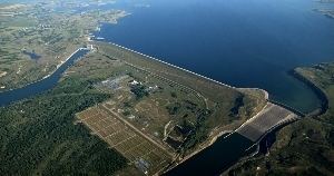
Garrison Dam is an earth-fill embankment dam on the Missouri River in central North Dakota, constructed 1947-1953. The Three Affiliated Tribes owned the land needed to flood. Short of confiscation by eminent domain the tribes protested and achieved remuneration, but lost 94% of their agricultural land. Constructed by the U.S. Army Corps of Engineers from 1947-53 at over two miles (3 km) in length, the dam is the fifth-largest earthen dam in the world. The reservoir impounded by the dam is Lake Sakakawea, which extends to Williston and the confluence with the Yellowstone River, near the Montana border.
Contents
- Map of Garrison Dam Coleharbor ND 58531 USA
- LocationEdit
- HistoryEdit
- Energy generationEdit
- FishingEdit
- References
Map of Garrison Dam, Coleharbor, ND 58531, USA
LocationEdit
Garrison Dam is located between Riverdale and Pick City, named after the town of Garrison, directly north of the dam, across the reservoir. The dam is approximately midway between Bismarck and Minot, about 10 miles (16 km) west of U.S. highway 83.
HistoryEdit
The dam was part of a flood control and power generation project named the Pick-Sloan Project along the river, after the two plan developers, Colonel Lewis A. Pick and William Glenn Sloan. In order to construct the dam, the US government needed to purchase 152,360 acres (616.6 km2) in the Fort Berthold Reservation that would be flooded by the creation of Lake Sakakawea. These lands were owned by the Three Affiliated Tribes, who had been living there "had been their home for perhaps more than a millennium". Threatened by confiscation under eminent domain the tribes protested. A complete block of Garrison Dam power was denied because it would violate the 1935 Rural Electrification Act. The tribes achieved remuneration, but lost 94% of their agricultural land. in 1947, when they were forced to accept $5,105,625, increased to $7.5 million in 1949. The final settlement legislation denied tribes' right to use the reservoir shoreline for grazing, hunting, fishing, or other purposes, including irrigation development and royalty rights on all subsurface minerals within the reservoir area. About 1700 residents were forcibly relocated, some to New Town, North Dakota. Thus Garrison Dam almost totally destroyed the traditional way of life for the Three Affiliated Tribes. Construction on the $300 million dam project began in 1947, and its embankment was enclosed in April 1953. The dam was dedicated by President Eisenhower two months later. The Corps of Engineers completed earthwork in the fall of 1954.
In June 2011, in response to the 2011 Missouri River Floods, the dam was releasing over 140,000 cubic feet per second (4,000 m3/s), which greatly exceeded its previous record release of 65,000 cu ft/s (1,800 m3/s) set in 1997. The first use of the emergency spillway due to flooding started on June 1, 2011 at 8:00am.
Energy generationEdit
Hydropower turbines at Garrison Dam have an electric power generating nameplate capacity of 583.3 megawatts. Average production of 240 megawatts serves several hundred thousand customers.
FishingEdit
The Garrison Dam National Fish Hatchery is the world's largest walleye and northern pike producing facility and also works to restore endangered species, such as the pallid sturgeon.