
Opening date 1957 Height 23 m Surface area 127.1 km² Construction began 1952 | Status Operational Catchment area 723,850 km² | |
 | ||
Type of dam Embankment, rolled-earth and chalk-fill Similar Fort Randall Dam, Big Bend Dam, Oahe Dam, Lewis & Clark State Recreation, Fort Peck Dam | ||
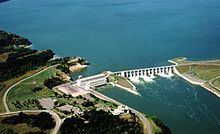
Gavins Point Dam is a hydroelectric dam on the Missouri River in the U.S. states of Nebraska and South Dakota. Built from 1952 to 1957, it impounds Lewis and Clark Lake. The dam is on the Nebraska-South Dakota border, west of Yankton, South Dakota. During the 2011 Missouri River Flood the dam was damaged by debris and a significant portion of rocks were dislodged from its upstream side. The U.S. Army Corps of Engineers soon began repairs to the dam and its spillway gates. Pressure sensors were also installed in concrete portion of the dam.
Map of Gavins Point Dam, Yankton, SD 57078, USA
Gavins Point Dam is the lowermost dam on the Missouri, and was built as part of the Pick-Sloan Plan. The dam area (with Lewis and Clark Lake) is a very popular regional tourist destination. The next dam upstream is the Fort Randall Dam.
The stretch of the Missouri immediately downstream of Gavins Point Dam is the only significant section of non-channelized meandering stream on the lower portion of the river. This federally designated Wild and Scenic River is among the last free-flowing stretches of the Missouri; it exhibits the islands, bars, chutes, and snags that once characterized the "Mighty Mo".
The dam has a hydroelectric plant with three generators, each having a nameplate capacity of 44,099 kW, for a total of 132.297 MW.