
Country USA | ||
 | ||
Similar | ||
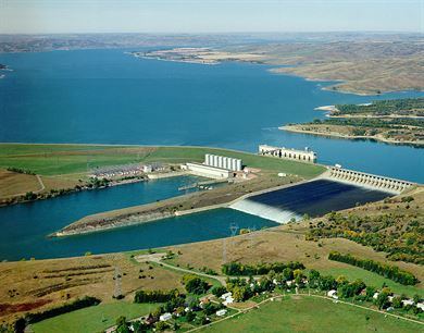
Fort randall dam pickstown sd
The Fort Randall Dam is an earth embankment dam impounding the Missouri River in South Dakota, United States and forming Lake Francis Case. It is one of six Missouri River dams, four being located in South Dakota.
Contents
- Fort randall dam pickstown sd
- Map of Fort Randall Dam Southeast Gregory SD 57335 USA
- Fort randall dam flood release tunnels
- Visitor Center
- References
Map of Fort Randall Dam, Southeast Gregory, SD 57335, USA
The dam was authorized by the Flood Control Act of 1944 and plays a key role in the Pick-Sloan Plan for development of water resources in the Missouri River basin. The Corps of Engineers began construction of Fort Randall Dam in 1946, and it was the first Pick-Sloan dam completed by the Omaha District. President Dwight D. Eisenhower threw the switch that started the first power generating unit in 1954. When completed in 1956, Fort Randall Dam and the Lake Francis Case Project cost approximately $200 million.
The eight generating units of the Fort Randall Dam are capable of generating 40 megawatts of electricity each, with an annual production of 1.727 billion kilowatt hours. The combined maximum capacity of 320 megawatts is enough to supply 245,000 households, according to the Corps of Engineers. The river behind the dam drains an area of 263,480 mi² (682,410 km²). Its reservoir, Lake Francis Case, has a surface area of 102,000 acres (41,000 ha) at maximum operating pool, coinciding with a volume of 5,700,000 acre feet (7.0×10⁹ m3).
The Fort Randall Dam is located in southeast South Dakota within sight of its namesake Fort Randall at 43°03′35″N 98°33′43″W (GNIS); by Pickstown, South Dakota on the east bank of the river; 12 miles (19 km) west of Wagner, South Dakota, and 25 miles (40 km) northeast of Spencer, Nebraska, on US 18/US 281.
In June 2011, in response to the 2011 Missouri River Floods, the dam was releasing over 143,000 cubic feet per second (4,000 m3/s), which greatly exceeded its previous record release of 67,000 cu ft/s (1,900 m3/s) set in 1997.
Fort randall dam flood release tunnels
Visitor Center
The Fort Randall Visitor Center is located on the western edge of Pickstown, South Dakota along U.S. Highway 281 and 18. Open from Memorial Day through Labor Day, the visitor center offers a view of Fort Randall Dam, Lake Francis Case and the Missouri River. Exhibits highlight the dam's construction, area natural and cultural history and paleontology. There is also a freshwater aquarium with fish species found in the Missouri River.