
Length 28.5 mi (45.9 km) | Designation National Recreation Trail | |
 | ||
Similar Chantry Flat, Santa Anita Canyon, Sturtevant Falls, Silver Moccasin Trail, Arroyo Seco | ||
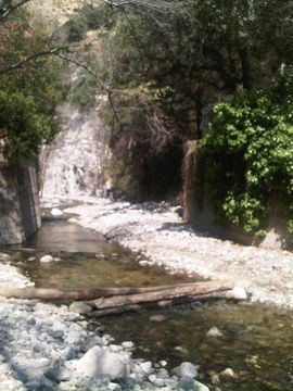
The Gabrielino Trail is a United States National Recreation Trail that runs through the Angeles National Forest with trailheads at Windsor Avenue in Altadena, California on the west end and Chantry Flat, just north of Arcadia, California, on the east. It passes through three major watersheds and has an elevation gain/loss of 3,500 ft (1,100 m)
Contents
Map of Gabrieleno Trail, Azusa, CA 91702, USA
History
When several existing trails were renamed to make a "new" 28.5 mile (45 km) trail in 1970, in compliance with the National Trails System Act, the Forest Service announcement read as follows:
Directions
The trail winds its way from Chantry Flat, through Big Santa Anita Canyon past Sturtevant Falls and Sturtevant's Camp, then over Newcomb's Pass into the West Fork of the San Gabriel River. The trail meets the river at Devore Campground then follows the watercourse upstream to West Fork Campground.
To this point, the Gabrielino Trail has been tracing the Silver Moccasin Trail. It is across the stream from West Fork Campground that the Silver Moccasin Trail heads up Shortcut Canyon for the San Gabriel High Country. To continue on the Gabrielino Trail, travel west to the head of the West Fork at Red Box Saddle near Mount Wilson. This is the trail's highest point.
From Red Box, the Gabrielino continues westward down the Arroyo Seco through Commodore Switzer Trail Camp, Oakwilde and Gould Mesa Campgrounds, and emerges from The Arroyo at the Jet Propulsion Laboratory.
Facilities
Potable water is available at the Chantry Flat trailhead, but otherwise one must boil or filter the stream water. Very little cell phone service along the entire route.
The following is a list of Forest Service facilities along the route of the Gabrielino Trail, east to west: