
Established 1750–1759 | Opened 1720 | |
 | ||
Similar Scadding Cabin, Queen's Wharf Lighthouse, Hogg's Hollow Bridge, Commerce Court West, Fort York | ||
Fort Rouillé and Fort Toronto were French trading posts located in Toronto, Ontario, Canada. Fort Rouillé was named for Antoine Louis Rouillé, who at the time of its establishment around 1750 was Secretary of State for the Navy in the administration of Louis XV. It was abandoned in 1759 due to the turbulence of the Seven Years' War.
Contents
The fort site is now part of the public lands of Exhibition Place. It is also the name of a short street, Fort Rouille Street, located approximately 1 km (0.62 mi) north of the fort site accessible from Springhurst Avenue with a few homes mostly the west side and the east serves as the entrance for streetcars or buses using the Dufferin streetcar loop.
Three French fortifications were located in what is now known as Toronto:
History
Its construction was ordered by the Marquis de la Jonquière, then governor of New France, in order to further establish a French presence in the area, and to intercept the trade of aboriginals travelling towards a British fur-trading post in present-day Oswego. According to a report of the Abbé Picquet, the aboriginals received a larger amount of silver for their beavers at Oswego. Although they preferred French brandy, this was not enough to dissuade the natives from going to Oswego. "To destroy the trade there, the King's posts ought to have been supplied with the same goods as Chouegen (Oswego) and at the same price." Learning that the aboriginals travelled south along the Toronto Carrying-Place trail, the decision was made to locate the fort at Toronto.
The new fort was named for Antoine Louis Rouillé, Comte de Jouy and French Minister of Marine and Colonies from 1749–1753.
Abbé Picquet visited Rouillé in 1752. He found good bread and wine there and it was better-equipped than other outposts. The Mississaugas there expressed a wish for Picquet to build a church there; they had only been built a canteen. Picquet had worked among the Iroquois south of the lake and the Mississaugas felt that the Iroquois had been better treated.
In 1756, war was declared between Britain and France. In 1757, with the garrison elsewhere, the Mississaugas looted the fort. A message was sent to Fort Niagara and the French returned the next day to take back the fort. The Mississaugas confessed to the plot, saying that they thought the French had been driven out and they were taking items away from the British. According to a report of a Captain Pierre Pouchot, he believed that they had only wanted the French brandy.
In 1758, the order was given to reinforce Fort Niagara and all men and loyal natives were called to defend it. After the fall of Fort Niagara in July 1759, the British under Lieutenant Francis came to Rouillé and found only burnt timbers.
After the destruction of Fort Rouille no attempt was made to re-establish a settlement in the vicinity until more than thirty years later, when Governor Simcoe laid down the foundations of York in 1793, four miles east of the French stockade.
Description
A first-hand account of the fort describes the fort. “The fort of Toronto was at the end of the bay, on the side which is quite elevated and covered by flat rock, so that vessels cannot approach within cannon shot. This fort or post was a square about 180 feet on a side externally with flanks of fifteen feet. The curtains formed the buildings of the fort. It was very well built, piece upon piece, but was only useful for trade. A league west of the fort is the mouth of the Toronto river, which is of considerable size. The river communicates with Lake Huron by a portage of 15 leagues, and is frequented by the Indians, who come from the north.”
It was a small palisaded fort with a bastion at each of its four corners. The 180 feet (55 m) × 180 feet (55 m) fort consisted of five buildings: a corps de garde, storeroom, barracks, blacksmithy, and a building for the officers. A drawing [1] purported to date from 1749 shows the fort adjacent to Lake Ontario. Today the location is a hundred metres or so from the lake's current shoreline, which has been infilled.
A wall surrounded the fort with an entrance to the south facing Lake Ontario and a small road (chemin). Captain Gother Mann showed the layout in his map, “Plan of the Proposed Toronto Harbour,” dated December 6, 1788. The map shows five buildings in the stockade as well as the bounds of the quadrangle enclosed by the palisades.
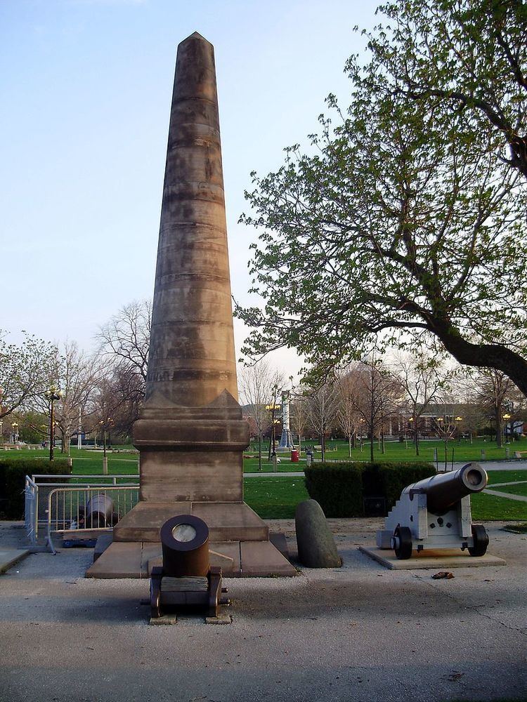
Fort Rouillé Monument
Vestiges of the fort remained for many years afterwards. When Toronto secured part of the garrison common for the Toronto Industrial Exhibition, the fort site's mounds were levelled and some depressions filled in. To mark the spot, a large granite boulder was dredged up from the bay, inscribed "This cairn marks exact spot of Fort Rouile, commonly known as Fort Toronto, an Indian Trading Post and Stockade. Established 1749 AD, by the order of the government of Louis XV in accordance with the recommendations of the Count de la Galissonniere, Administrator of New France 1717–1749. Erected by the Corporation of the City of Toronto, 1878." In the summer of 1887, a large obelisk was unveiled to mark the spot where the original French-built Fort Rouillé was erected. The site is now part of Exhibition Place.
The grounds were excavated in 1979 and 1980 by the Toronto Historical Board, and again in 1982 by the Youth Committee of the Toronto Sesquicentennial Board. The outline of the original fort has been marked out in concrete around the obelisk. Two commemorative plaques – one in English, and one in French – are attached to the base of the obelisk, placed there by the Ontario Heritage Foundation. To the north, a third plaque commemorates the excavation done on the site, and to the west, a fourth plaque commemorates a visit to the site by Bertrand Delanoë, mayor of Paris, on September 6, 2003.
A concrete outline of the original fort is marked on the ground and is visible here.
The obelisk is flanked by a cannon and a mortar, dating from the 1850s. Perhaps ironically, they are all British. A second cannon, present on the west side of the obelisk as recently as 2005, has since been removed.
Plaque
The English-language plaque erected by the Ontario Heritage Foundation in 1957 at the Fort Rouillé monument reads:
The last French post built in present-day southern Ontario, Fort Rouillé, more commonly known as Fort Toronto, was erected on this site in 1750-51. It was established by order of the Marquis de La Jonquière, Governor of New France, to help strengthen French control of the Great Lakes and was located here near an important portage to capture the trade of Indians travelling southeast toward the British fur- trading centre at Oswego. A small frontier post, Fort Rouillé was a palisaded fortification with four bastions and five main buildings. It apparently prospered until hostilities between the French and British increased in the mid-1750s. After the evacuation of other French posts on Lake Ontario, Fort Rouillé was destroyed by its garrison in July 1759.