
Prominence 315 m Parent range Sierra Nevada | Elevation 3,791 m Mountain range Sierra Nevada | |
 | ||
Listing Sierra Peaks SectionWestern States Climbers Emblem peak Easiest route Simple scramble, class 2 Similar Mount Maclure, Sawtooth Peak, Mount Barnard, Mount McAdie, Mount Mallory | ||
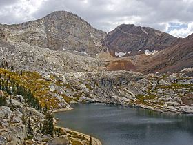
Florence Peak is a mountain located on the Great Western Divide, a sub-range of the southern Sierra Nevada of California. It is located about 6 miles (9.7 km) southeast of the community of Silver City and 4.5 miles (7.2 km) from the roads end at Mineral King. It marks the southern boundary of Sequoia National Park. On the summit the Sequoia-Kings Canyon Wilderness, the John Krebs Wilderness and Golden Trout Wilderness meet.
Contents
Map of Florence Peak, California, USA
Geography
The peak rises to an elevation of 12,438 feet (3,791 m), making it one of the highest mountains south of Mount Whitney. The Franklin Lakes, a series of tarns, lie in a cirque on north side of the peak and these drain into the Kaweah River by way of Franklin Creek. The eastern slopes drain into the Kern River. The southwestern flank drains into the 10,000-foot (3,048 m) Bullfrog Lakes and thence into the Little Kern River.
The high elevation of the peak means that most of the precipitation it receives falls as snow.