
Country United States County Flathead ZIP codes 59901-59904 Elevation 901 m Population 20,972 (2013) | State Montana Time zone Mountain (MST) (UTC-7) Area code(s) 406 Local time Friday 10:19 PM | |
 | ||
Weather 4°C, Wind NW at 5 km/h, 69% Humidity University | ||
Kalispell is a city in, and the county seat of Flathead County, Montana, United States. The 2015 Census estimates put Kalispell's population at 22,052. The Kalispell Micropolitan Statistical Area has a population of 93,068 and it is the largest city and commercial center of northwest Montana. The name Kalispell is a Salish word meaning "flat land above the lake". Kalispell is also the gateway to Glacier National Park.
Contents
- Map of Kalispell MT 59901 USA
- History
- Geography and climate
- 2010 census
- 2000 census
- Transportation
- Agriculture
- Local media
- References
Map of Kalispell, MT 59901, USA
History
Working using his own capital, Charles Edward Conrad, a businessman and banker from Fort Benton, Montana, formed the Kalispell Townsite Company with three other men. The townsite was quickly platted and lots began selling by the spring of 1891. Conrad built a large mansion in Kalispell in 1895. Kalispell was officially incorporated as a city in 1892. Since that time, the city of Kalispell has continued to grow in population reaching 19,927 in 2010. As the largest city in Northwest Montana, Kalispell serves as the county seat and commercial center of Flathead County. The city is considered a secondary trade center with a trade area of approximately 130,000. The city also is home to Kalispell Regional Medical Center, which boasts a 150-bed facility.
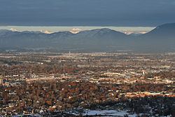
Nestled in the Flathead valley, Kalispell is 31 miles (50 km) from Glacier National Park and 22 miles (35 km) from Hungry Horse Dam. Skiers have access to Whitefish Mountain Resort on Big Mountain and Blacktail Mountain Ski Area each 17 miles (27 km) away. Flathead Lake is 7 miles (11 km) away. Buffalo Hill Golf Club, designed by Robert Muir Graves, serves the needs of golfers.
The tribal schools nearby offer classes in the Kalispel–Spokane–Flathead language, a language nest, and intensive language training for adults. There is a Salish language school and training center in Arlee, Montana.
Geography and climate
Kalispell is located at 48°11′52″N 114°18′58″W (48.197801, −114.316068), at an altitude of 2,956 feet (901 m).
According to the United States Census Bureau, the city has a total area of 11.73 square miles (30.38 km2), of which, 11.64 square miles (30.15 km2) is land and 0.09 square miles (0.23 km2) is water.
Kalispell is located 7 miles (11 km) north of Flathead Lake, which is the largest natural freshwater lake in the continental United States west of the Mississippi River.
Kalispell experiences a cold semi-arid climate (Köppen BSk), with long, cold and moderately snowy winters, hot and dry summers, and short springs and autumns in between. Nights are much cooler than daytime highs. Snow usually occurs from late October/early November to March.
2010 census
As of the census of 2010, there were 19,927 people, 8,638 households, and 4,944 families residing in the city. The population density was 1,711.9 inhabitants per square mile (661.0/km2). There were 9,379 housing units at an average density of 805.8 per square mile (311.1/km2). The racial makeup of the city was 94.2% White, 0.2% African American, 1.3% Native American, 1.0% Asian, 0.1% Pacific Islander, 0.6% from other races, and 2.6% from two or more races. Hispanic or Latino of any race were 2.9% of the population.
There were 8,638 households of which 30.8% had children under the age of 18 living with them, 40.4% were married couples living together, 12.0% had a female householder with no husband present, 4.8% had a male householder with no wife present, and 42.8% were non-families. 35.7% of all households were made up of individuals and 14.4% had someone living alone who was 65 years of age or older. The average household size was 2.26 and the average family size was 2.94.
The median age in the city was 34.5 years. 25.1% of residents were under the age of 18; 9.5% were between the ages of 18 and 24; 27.2% were from 25 to 44; 22.7% were from 45 to 64; and 15.4% were 65 years of age or older. The gender makeup of the city was 47.3% male and 52.7% female.
2000 census
As of the census of 2000, there were 14,223 people, 6,142 households, and 3,494 families residing in the city. The population density was 2,605.7 people per square mile (1,005.8/km²). There were 6,532 housing units at an average density of 1,196.7 per square mile (461.9/km²). The racial makeup of the city was 95.84% White, 0.28% African American, 1.22% Native American, 0.56% Asian, 0.04% Pacific Islander, 0.39% from other races, and 1.66% from two or more races. Hispanic or Latino of any race were 1.55% of the population. 21.7% were of German, 12.0% Irish, 11.3% Norwegian, 10.7% English and 6.6% United States or American ancestry.
There were 6,142 households out of which 28.9% had children under the age of 18 living with them, 42.0% were married couples living together, 11.2% had a female householder with no husband present, and 43.1% were non-families. 36.8% of all households were made up of individuals and 15.5% had someone living alone who was 65 years of age or older. The average household size was 2.209 and the average family size was 2.92.
In the city, the age distribution of the population shows 24.0% under the age of 18, 10.0% from 18 to 24, 26.8% from 25 to 44, 20.9% from 45 to 64, and 18.3% who were 65 years of age or older. The median age was 38 years. For every 100 females there were 87.7 males. For every 100 females age 18 and over, there were 82.1 males.
The median income for a household in the city was $28,567, and the median income for a family was $36,554. Males had a median income of $29,431 versus $20,122 for females. The per capita income for the city was $16,224. About 10.1% of families and 15.9% of the population were below the poverty line, including 17.1% of those under age 18 and 13.0% of those age 65 or over.
Transportation
Kalispell is located at the intersection of U.S. Routes 2 and 93. Commercial air service is offered at Glacier Park International Airport, located approximately 8 miles (13 km) northeast of Kalispell off U.S. Route 2 between Kalispell and Columbia Falls.
Kalispell City Airport, located in the southern part of the city, offers general aviation service.
Amtrak's Empire Builder service between Chicago and either Seattle, Washington, or Portland, Oregon, is available in Whitefish, approximately 15 miles (24 km) north.
Eagle Transit, an agency of Flathead County, offers local transit service within and connecting Kalispell, Columbia Falls and Whitefish, as well as paratransit demand-responsive service.
Agriculture
As of July 2014, one of Montana's last mint farms, growing peppermint and spearmint, is located near Kalispell.
Local media
Kalispell is one of the largest media markets in Montana. It is the second largest over the air radio market in Montana, behind only Billings.