
Highest elevation 3,749 ft (1,142.7 m) | Total islands 1 Area 8.753 km² | |
 | ||
Indian Reservation | ||
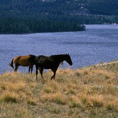
Wild horse island tour on flathead lake montana
Wild Horse Island is the largest island on Flathead Lake, the largest freshwater lake in Montana. For centuries, the Salish-Kootenai used the island, approximately 2,164 acres (876 ha) in size, in order to pasture horses and keep them from being stolen by other tribes. The island was part of the Flathead Indian Reservation from the time of its creation in 1872 up until its dismantlement in 1904, when the island was divided into individual plots of land. A number of attempts were made on the island towards agricultural development, but none succeeded.
Contents
- Wild horse island tour on flathead lake montana
- Map of Wild Horse Island Montana 59910 USA
- Wild horse island state park on flathead lake in montana
- Climate and topographyEdit
- References
Map of Wild Horse Island, Montana 59910, USA
Between 1910-1915, homesteaders on the island cut down much of the old growth trees and introduced non-native grasses and other plant species. These species have competed with and overtaken much of the short-grass prairie that herbivorous wildlife need to survive. This short grass prairie is one of the last few remaining in Montana, and because of this efforts must be made to control various animal species on the island in order to preserve the grasses from over-pasturing and extinction. Bighorn Sheep, for example, are managed at around 100 sheep. In 2014, the population was between 160-200 sheep, and Montana Fish, Wildlife, & Parks worked to relocate 59 sheep to other herds in Northwest Montana.
Protected as a state park since 1978, the island near Big Arm Bay is home to abundant wildlife including bighorn sheep, mule deer, waterfowl, bald eagles. As of 2013, the wild horse population was five mares and one gelding. Access is by boat only and for day–use only. It is managed by Montana Fish, Wildlife & Parks and lies within both the Flathead Indian Reservation and Lake County, Montana. There are 56 private lots on the island, about an acre (0.4 ha) each. The highest point is at 3,749 feet (1,143 m), which is 853 feet (260 m) above the island's shores.
Wild horse island state park on flathead lake in montana
Climate and topographyEdit
A study conducted over a 25-year span has shown the average yearly precipitation on Wild Horse Island to be 15.7 inches. However, while this is the average, over 50% of the years in the study were found to have a below average precipitation rate. The average temperature ranges from 24F-66F, with spikes sinking below 5F during colder months and above 90F during the hotter months in dryer years. Overall, the island experiences below freezing temperatures about two thirds of the year.
Wild Horse Island was formed by the Cordilleran Glacier, giving the island a varying topography. The glacier caused the hills in the center of the island, ranging from 3,277-3,745 ft. above sea level, to be formed into roche mountenee, with rugged northern faces and rugged southern cliffs. Meadows sprawl the western and southern shores, while grasslands cover the southeast. The northern side of the island boasts forests of Ponderosa Pine and Douglas Fir trees.